Shelburne in Chittenden County, Vermont — The American Northeast (New England)
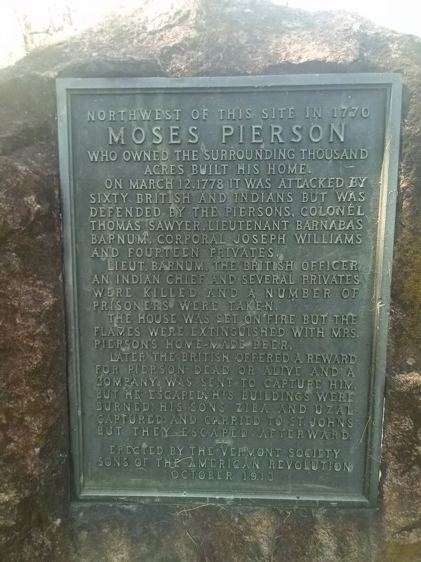
Moses Pierson
Photographed by Tim Dusablon, May 17, 2024
1. Moses Pierson Marker
Moses Pierson
who owned the surrounding thousand
acres built his home.
Lieut. Barnum, the British officer, and Indian Chief and several privates were killed and a number of prisoners were taken.
The house was set on fire but the flames were extinguished with Mrs. Pierson's home-made beer.
Later the British offered a reward for Pierson dead or alive and a company was sent to capture him but he escaped. His buildings were burned. His sons Ziba and Uzal captured and carried to St. Johns but they escaped afterward.
October 1913
Erected 1913 by Sons of the American Revolution.
Topics. This historical marker is listed in this topic list: War, US Revolutionary. A significant historical date for this entry is March 12, 1778.
Location. 44° 21.757′ N, 73° 15.952′ W. Marker is in Shelburne, Vermont, in Chittenden County. It is on
this page online

Regionally, this marker is in the Champlain Valley and in Greater Burlington. It is also in the American Northeast and in New England. Globally, it is in North America, the Western Hemisphere, the Western World, and the Anglosphere. Historically, it finds itself in what was once the Viceroyalty of New France and also the Vermont Republic.
Other nearby markers. At least 8 other markers are within 2 miles of this marker, measured as the crow flies: Circus Building (approx. 1.7 miles away); Circus Building & Carousel (approx. 1.8 miles away); The Beach Complex (approx. 1.8 miles away); Rail Car Grand Isle (approx. 1.8 miles away); a different marker also named The Rail Car Grand Isle (approx. 1.8 miles away); Beach Gallery (approx. 1.8 miles away); Railroad Station (approx. 1.8 miles away); Locomotive 220 (approx. 1.8 miles away). Touch for a list and map of all markers in Shelburne.

Photographed by Tim Dusablon, May 17, 2024
2. Moses Pierson Marker

Photographed by Tim Dusablon, May 17, 2024
3. Moses Pierson Marker
Credits. This page was last revised on June 1, 2024. It was originally submitted on May 26, 2024, by Tim Dusablon of Georgia, Vermont. This page has been viewed 523 times since then and 66 times this year. Photos: 1, 2, 3. submitted on May 26, 2024, by Tim Dusablon of Georgia, Vermont. • Michael Herrick was the editor who published this page.
