
Lincoln in Lincolnshire, England, United Kingdom — Northwestern Europe (the British Isles)
Welcome to the City of Lincoln
Lincoln's Timeline
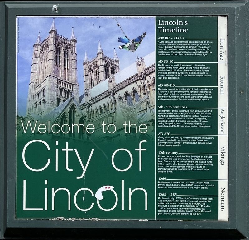
Photographed by Ray Gurganus, April 15, 2024
1. Lincoln's Timeline Marker
400 BC - AD 43
A Late Iron Age settlement has been identified on one of the islands in what was then a much larger Brayford Pool. The main significance of "Lindon", "the place by the pool", may have been as a meeting place and for tribal rituals. Precious metal objects were deposited in the river east of Lincoln from the Late Bronze Age.
AD 50-80
The Romans arrived in Lincoln and built a timber fortress for the Ninth Legion on the hilltop. The name was latinized to "Lindum". Areas outside the fortress were also occupied by traders, local people and for supply buildings. In AD 71 the Second Legion Adutrix took over occupation.
AD 80-410
The army moved on, and the site of the fortress became a colonia, a self-governing town for retired legionaries. New public buildings, Including the civic centre (forum and basilica), temples, and baths were constructed, as well as an aqueduct, fountain, and drainage system.
5th-9th centuries
The Romans' official withdrawal from Britain in AD 410 spelt the end of towns. Anglo-Saxons from across the North Sea coastlands moved into Eastern England and in due course established
this page online
AD 870
Viking raids, followed by military campaigns into Eastern England resulted in settlement and the Danes had gained political control - bringing about a major revival in trade and prosperity.
10th century
Lincoln became one of the 'Five Boroughs of the East Midlands' and was an important fortified centre. In the late 10th century Lincoln was one of the leading mints in the country, after London. Lincoln became a thriving inland port receiving goods from other parts of Danelaw as well as Scandinavia, Europe and as far away as Syria.
1066
By the time of the Norman Conquest, Lincoln was a thriving town, home to about 6,000 people with a market based around the waterways at the foot of the hill.
1068-1185
On the authority of William the Conqueror a large castle was built, followed in 1072 by the construction of the cathedral-as much a fortress as a church. Fire destroyed a large part of the Cathedral in 1141 and in 1185 an earthquake caused more damage: the rebuilding created the Early English Gothic Cathedral, part of which, remains standing to this day.
Topics. This historical marker is listed in this topic list: Settlements & Settlers.
Location. 53° 14.065′ N, 0° 32.306′ W. Marker is in Lincoln, England, in Lincolnshire. It is on Exchequer Gate. Touch for map. Marker is at or near this postal address: 2A Exchequer Gate, Lincoln, England LN2 1PZ, United Kingdom. Touch for directions.

Regionally, this marker is in England’s Midlands. Globally, it is on the Atlantic Ocean, in the North Atlantic Region, in Europe, in Atlantic Europe, on one of the British Isles, in the Western World, and in the Anglosphere. Historically, it finds itself in what was once the Roman Empire.
Other nearby markers. At least 8 other markers are within walking distance of this marker: Lincoln's Character Quarters (here, next to this marker); Historic Lincoln (here, next to this marker); Magna Carta (here, next to this marker); Medieval Bishop's Palace (here, next to this marker); Castle Hill (here, next to this marker); Welcome to the Cathedral Quarter (here, next to this marker); Leigh-Pemberton House (a few steps from this marker); The Roman Upper South Gate (about 90 meters away, measured in a direct line). Touch for a list and map of all markers in Lincoln.
Credits. This page was last revised on June 5, 2024. It was originally submitted on May 28, 2024, by Ray Gurganus of Washington, District of Columbia. This page has been viewed 494 times since then and 387 times this year. Photo 1. submitted on May 28, 2024, by Ray Gurganus of Washington, District of Columbia. • Andrew Ruppenstein was the editor who published this page.
Editor’s want-list for this marker. Photo of the marker within its surroundings. • Can you help?
