Valkenburg in Valkenburg aan de Geul, Limburg, Netherlands — Northwestern Europe
466th Bomb Group Plane Crash
| — | 75 jaar Bevrijding fotoroute | — |

Photographed by Andrew Ruppenstein, May 27, 2024
1. 466th Bomb Group Plane Crash Marker

On March 12, 1945, an American B-24 Liberator crashed here after the aircraft lost three engines and the entire crew had parachuted to safety. The team led by pilot and lieutenant Charles A. Felts carried out 17 combat missions until the surrender of Germany, including the mission that ended in the crash at Sibbe. Standing (from left to right): Charles Dondes (navigator), Edmond Cody Hall (co-pilot), Charles A. Felts (pilot), Edwin N. Kimmel (B). Kneeling
this page online
Erected 2019. (Marker Number 19/20.)
Topics and series. This memorial is listed in these topic lists: Air & Space • War, World II. In addition, it is included in the Valkenburg Bevrijding/Liberation Route series list. A significant historical date for this entry is March 12, 1945.
Location. 50° 50.905′ N, 5° 49.128′ E. Memorial is in Valkenburg, Limburg, in Valkenburg aan de Geul. It is at the intersection of Daalhemerweg and Dorpstraat, on the left when traveling north on Daalhemerweg. Touch for map. Memorial is at or near this postal address: Daalhemerweg 150, Valkenburg, Limburg 6301 BD, Netherlands. Touch for directions.

Regionally, it is in Europe, the European Union, Atlantic Europe, the Benelux Low Countries, the Schengen Area, Western Europe, and the Western World. Historically, it finds itself in what was once the Roman Empire and specifically also the Holy Roman Empire.
Other nearby markers. At least 8 other markers are within 2 kilometers of this marker, measured
Photographed by Andrew Ruppenstein, May 27, 2024
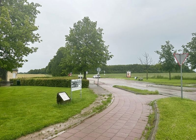
2. 466th Bomb Group Plane Crash Marker - wide view
The marker is visible here placed next to a plaque related to the artwork in the center of the traffic circle (not shown).
Also see . . . Charles Samuel Dondes (American Air Museum in Britain).
Excerpt of Dondes’ account of the crash: Charles Dondes-Crew 784 Navigator tells of the plight of the Felts crew:'At 1105 hours, while on a Mag. heading of 094 degrees our #1 engine leaked oil. The oil piled up and froze and the engine was feathered at 1202. Were then at 51-52N and 08-12E. We had to strain the remaining engines to keep up and at some point we lost a second engine-perhaps from flak, perhaps from strain. At 1239 our bombs were 'away' on target at 50-20N and 80-46E. At this time we were at 20,100 feet with an indicated airspeed of 155 knots. ''From then until we bailed out, a third engine started to give trouble. At 1350, some 71 minutes later, the whole crew bailed out. We were at 13,500 feet at 1320 and on a Mag. heading of 290 degrees. I have no record of the altitude or the heading for the last 30 minutes. The pilot and I were operating very verbally and he had extreme difficulty in holding the plane on any heading for any duration. ''When the pilot gave the bail out command, all crew members except the pilot and the copilot went to the bomb bay. I left first. All was business-like at the time, as it had been all along. ''We all parachuted within sight of each other over Valkenburg, Holland and were escorted by American burial personnel to a headquarters, for we had landed near a cemetery (probably Margraten). The a/c went into a flat spin and had a pancake landing (at Sibbe).(Submitted on June 1, 2024.)
Credits. This page was last revised on June 1, 2024. It was originally submitted on June 1, 2024, by Andrew Ruppenstein of Lamorinda, California. This page has been viewed 252 times since then and 35 times this year. Photos: 1, 2. submitted on June 1, 2024, by Andrew Ruppenstein of Lamorinda, California.
