Columbia in Lancaster County, Pennsylvania — The American Northeast (Mid-Atlantic)
St. Charles
Hot-Blast Anthracite Coal Furnace (1854-1897)
Photographed by Annette Fillmore, June 3, 2024
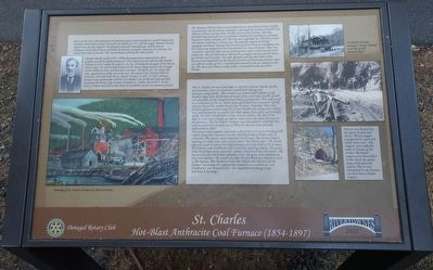
1. St. Charles Marker
Peter Grubb was a Pennsylvania iron industry pioneer who founded the Grubb Family Iron Dynasty when he discovered Cornwall Iron Banks in 1737, still the largest domestic iron ore deposit east of Lake Superior. He founded Cornwall, Pennsylvania and became an ironmaster as he mined the ore and built the historic Cornwall Charcoal Iron Furnace. He named them after Cornwall, UK, the birthplace of his father John Grubb.
Clement Brooke Grubb (1815-1889), four generations removed from Peter Grubb, entered the family business in 1832 and partnered with his older brother Edward in 1833, under the name E. & C.B., becoming the manager of the Mount Hope Estate. He sold his half interest in the Mount Hope Estate to his younger brother Alfred in 1845 and moved to Lancaster. He left E. & C.B. about that time, apparently to strike out on his own. He acquired the Chestnut Hill Ore Banks by 1851 and built the St. Charles Furnace in 1852. In 1872, Clement formed a new partnership with his son Charles (C.B. Grubb and Son) and they purchased the Henry Clay Furnace (renamed St. Charles #2) in 1875. At his death, Clement was said to have
this page online
The Chestnut Hill Ore Mine was developed by two decendents(sic) of Peter Grubb, the gentleman who discovered, developed, and owned the famous Cornwall Iron Mine in Lebanon County about 20 miles north of this location. The mine provided lump and wash iron ore (limonite minerals) for smelting in a(sic) furnaces located in nearby Columbia, PA. The ores were suspended in a 100 foot or more soil column consisting of a heavy clay. The minerals originated through supergene enrichment meaning that iron derived from chemical weathering near the surface was redeposited and concentrated at at(sic) lower horizons. These ores contained a relatively high amount of phosporous(sic) which is deletrious for steel production. The ores did produce high quality wrought and cast iron for stoves, gun barrels, and iron plate. The mine operated until the mid-1880's when discovery and explotation(sic) of the Mesabi Iron Ores of Minnesota proved a more cost effective source of iron. A considerable amount of iron ore remains at this site. The site is now home to Lake Grubb, a recreational park near Silver Springs.
The

Photographed by Annette Fillmore, June 3, 2024
2. St. Charles Furnace & Marker
View of furnace (left) & marker (right) when heading south toward Columbia on the Northwest River Trail.
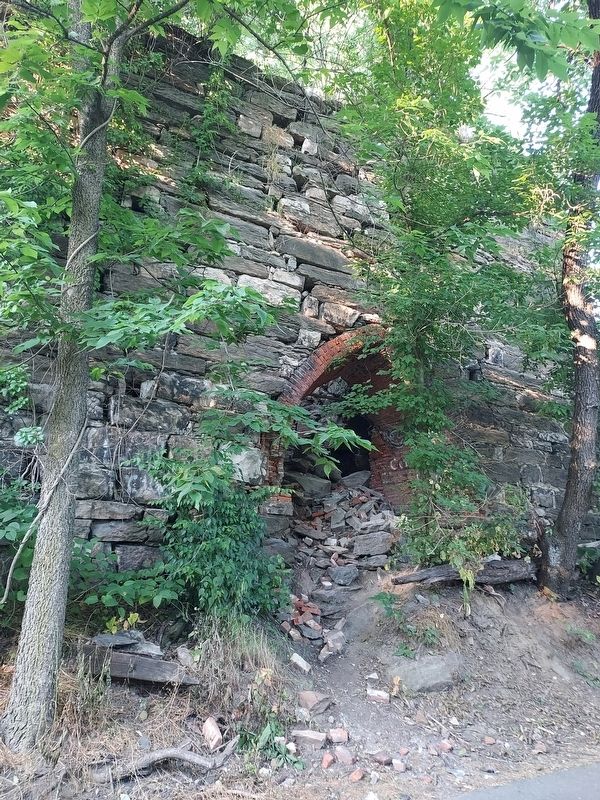
The square stack support and stone walls of the ore roaster building still remain along the Lancaster County Northwest River Trail north of Columbia. The square stack supported the furnace. The domed shaped openings on three sides were used to house the
Photographed by Annette Fillmore, June 3, 2024
3. St. Charles Furnace
View from the trail.
Iron ore was mined from the quarry by pick and shovel. The ore wagons transported on small rails called "pony rails." The wagons were pulled by mules to bottom of the incline. The loaded wagons were then pulled to the top of the quarry using steam powered engines. The ore was transported to the furnaces via mule drawn freight wagons.
Erected 2021 by Donegal Rotary Club & Rivertownes.
Topics and series. This historical marker is listed in these topic lists: Industry & Commerce • Settlements & Settlers. In addition,

Photographed by Annette Fillmore, June 3, 2024
4. St. Charles Furnace
Interior view of the furnace showing 2 of the 3 domed openings for the bustle pipes.
Location. 40° 2.322′ N, 76° 30.847′ W. Marker is in Columbia, Pennsylvania, in Lancaster County. It is on Lancaster County Northwest River Trail, on the left when traveling north. Touch for map. Marker is in this post office area: Columbia PA 17512, United States of America. Touch for directions.

Regionally, this marker is in South-Central Pennsylvania, specifically in Pennsylvania Dutch Country, and in the Susquehanna Valley. It is also in the American Northeast and in the Mid-Atlantic. Globally, it is in North America, the Western Hemisphere, the Western World, and the Anglosphere. Historically, it finds itself in what was once the Haudenosaunee (Iroquois) Confederacy and also one of the original Thirteen Colonies.
Other nearby markers. At least 8 other markers are within walking distance of this marker: Pennsylvania's Iron Industry Fuels Progress and Victory (approx. 0.3 miles away); Harry S. Dietz, Jr. and Dorothy Dietz Goodman (approx. 0.4 miles away); Columbia Underground Railroad Heritage (approx. 0.4 miles away); Zion Hill Cemetery (approx. 0.4 miles away); The Columbia Race Riots (approx. 0.4 miles away); Prelude to Gettysburg / A Desperate Plan (approx. 0.4 miles away); Free African Communities in Columbia (approx. 0.4 miles away); History of Zion Hill Cemetery (approx. 0.4 miles away). Touch for a list and map of all markers in Columbia.
Credits. This page was last revised on October 26, 2024. It was originally submitted on June 3, 2024, by Annette Fillmore of York, Pennsylvania. This page has been viewed 895 times since then and 237 times this year. Photos: 1, 2, 3, 4. submitted on June 3, 2024, by Annette Fillmore of York, Pennsylvania. • Bill Pfingsten was the editor who published this page.
