Franklin Township in Waverly in Ross County, Ohio — The American Midwest (Great Lakes)
The American Chestnut
Scioto Trail State Forest
Photographed by Cajun Scrambler, May 28, 2024
1. The American Chestnut Marker
Panel 1
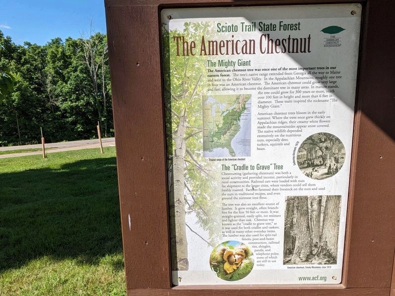
The Mighty Giant
The "Cradle to Grave" Tree
Chestnutting (gathering chestnuts) was both a social activity and provided income, particularly in rural communities. Railroad cars were loaded with nuts for shipment to the larger cities, where vendors could sell
this page online
The tree was also an excellent source of lumber. It grew straight, often branch- free for the first 50 feet or more. It was straight-grained, easily split, rot resistant and lighter than oak. Chestnut was known as the "cradle to grave tree," as it was used for both cradles and caskets, as well as many other everyday items. The lumber was also used for split-rail fences, post-and-beam construction, railroad ties, shingles, panels, and telephone poles; some of which are still in use today.
Chestnut Blight
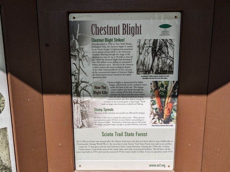
Chestnut Blight Strikes
First identified in 1904 in New York's Bronx Zoological Park, the chestnut blight is caused by an Asiatic fungus (Cryphonectria parasitica) and is almost always lethal to the American chestnut. Moving through the range of the chestnut at a rate of up to 30 miles a year, by the 1950s the chestnut blight had devastated over 200 million acres, killing an estimated 4 billion chestnut trees. The loss of the chestnut is often cited as the
Photographed by Cajun Scrambler, May 28, 2024
2. The American Chestnut Marker
Panel 2
Stump Sprouts
The roots of the chestnut are usually not affected by fungus, the base of the tree or stump for many years. These sprouts can sometimes grow 30 feet or more before succumbing to the chestnut blight. Sometimes a fortunate sprout will avoid the blight and grow large enough to produce flowers and seed.
The 9,390 acre forest was named after the Native American trail that ran from what is now Chillicothe to Portsmouth. During World War I, the area that is now Scioto
Photographed by Cajun Scrambler, May 28, 2024
3. The American Chestnut Marker
Panel 3
Restoring The Chestnut
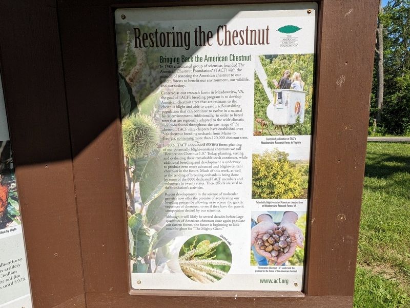
Bringing Back The Chestnut
In 1983 a dedicated group of scientists founded The American Chestnut Foundation® (TACF) with the mission of restoring the American chestnut to our eastern forests to benefit our environment, our wildlife, and our society.
Centered at our research farms in Meadowview, VA, the goal of TACF's breeding program is to develop American chestnut trees that are resistant to the chestnut blight and able to create a self-sustaining population that can continue to evolve in a natural forest environment. Additionally, in order to breed trees that are regionally adapted to the wide climatic variations found throughout the vast range of the chestnut, TACF state chapters have established over 300 chestnut breeding orchards from Maine
Photographed by Cajun Scrambler, May 28, 2024
4. The American Chestnut Marker
In 2009, TACF announced the first forest planting of our potentially blight-resistant chestnuts we call "Restoration Chestnut 1.0." Today, planting, testing and evaluating these remarkable seeds continues, while additional breeding and development is underway to produce even more advanced and blight-resistant chestnuts in the future. Much of this work, as well as the tending of breeding orchards is being done by some of the 6000 dedicated TACF members and volunteers in twenty states. These efforts are vital to the foundation's activities.
Recent developments in the science of molecular genetics now offer the promise of accelerating our breeding process by allowing us to screen the genetic sequences of chestnuts, to see if they have the genetic composition desired by our scientists.
Although it will likely be several decades before large quantities of American chestnuts once again populate our eastern forests, the future is beginning to look much brighter for "The Mighty Giant."
Erected by The American Chestnut Foundation.
Topics. This historical marker is listed in these topic lists: Horticulture & Forestry • Natural Resources.
Location. 39° 12.979′ N, 82° 58.564′ W. Marker is in Waverly, Ohio, in Ross County. It is in Franklin Township. It is on Stoney Creek Road (State Road 372) near North Ridge Road. Touch for map. Marker is at or near this postal address: 671 OH-372, Chillicothe OH 45601, United States of America. Touch for directions.

Regionally, this marker is in the Scioto Valley and in Southern Ohio Hill Country. It is also in the American Midwest, in the Corn Belt, and in Northern Appalachia. Globally, it is in North America, the Western Hemisphere, the Western World, and the Anglosphere. Historically, it finds itself in what was once the Viceroyalty of New France, the Haudenosaunee (Iroquois) Confederacy, the territory of the Mississippian Culture, and the Northwest Territory.
Other nearby markers. At least 8 other markers are within 4 miles of this marker, measured as the crow flies: Ohio Forest Management Through the Years (within shouting distance of this marker); Scioto Trail Fire Tower (within shouting distance of this marker); Ross County Underground Railroad / The Underground Railroad (approx. 0.4 miles away); Scioto Trail (approx. 1½ miles away); The Lending Tackle Box Tackle Box Program (approx. 1½ miles away); Historic Log Church Replica (approx. 1½ miles away); William Hewitt Monument (approx. 1½ miles away); German Settlers & Trustees Memorial (approx. 3½ miles away). Touch for a list and map of all markers in Waverly.
Also see . . . The American Chestnut Foundation official website. (Submitted on June 21, 2024, by Cajun Scrambler of Assumption, Louisiana.)
Credits. This page was last revised on June 21, 2024. It was originally submitted on June 21, 2024, by Cajun Scrambler of Assumption, Louisiana. This page has been viewed 364 times since then and 36 times this year. Photos: 1, 2, 3, 4. submitted on June 21, 2024, by Cajun Scrambler of Assumption, Louisiana.
