Arset El Bilk in Marrakesh, Marrakesh-Safi, Morocco — Africa (Northern Africa)
The Stone Fortress and the Gate of Ali
Photographed by J. Makali Bruton, May 19, 2024
1. The Stone Fortress and the Gate of Ali Marker

English
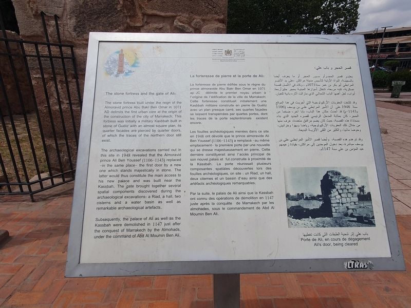
The stone fortress and the gate of Ali:
The stone fortress built under the reign of the Almoravid prince Abu Bakr Ben Omar in 1071 AD delimits the first urban core at the origin of the construction of the city of Marrakech; This fortress was initially a military Kasbbah built in stone of Guéliz with an almost square plan, its quarter facades are pierced by quarter doors, of which the traces of the northern door still exist.
The archaeological excavations carried out in this site in 1948 revealed that the Almoravid prince Ali Ben Youssef (1106-1143) replaced -in the same place- the first door by a new one which stands majestically in stone. The latter would thus constitute the main access to his new palace and was built near the Kassbah. The gate brought together several spatial components discovered during the archaeological excavations: a Riad, a hall, two cisterns and a water basin as well as remarkable archaeological artefacts.
Subsequently, the palace of Ali as well as the Kassbah were demolished in 1147 just after the conquest of Marrakech by the Almohads, under the command of
this page online
Ali's door, being cleared
La forteresse de pierre et la porte de Ali:
La forteresse de pierre édifiée sous le règne du prince almoravide Abu Bakr Ben Omar en 1071. délimite le premier noyau urbain à l'origine de l'édification de la ville de Marrakech; Cette forteresse constituait initialement une Kasbbah militaire construite en pierre de Guéliz avec un plan presque carré, ses quartes façades se laissent transpercées par quartes portes, dont les traces de la porte septentrionale existent encore.
Les fouilles archéologiques menées dans ce site en 1948 ont dévoilé que le prince almoravide Ali Ben Youssef (1106-1143) a remplacé -au même emplacement-la première porte par une nouvelle qui se dresse majestueusement en pierre. Cette dernière constituerait ainsi l'accès principal de son nouvel palais et fut construite à proximité de la Kassbah. La porte réunissait plusieurs composantes spatiales découvertes lors des fouilles archéologiques, on site: un Riad, un hall, deux citernes et un bassin d'eau ainsi que des artéfacts archéologiques remarquables.
Par la suite, le palais de Ali ainsi que

Photographed by J. Makali Bruton, May 19, 2024
2. The Stone Fortress and the Gate of Ali Marker
Porte de Ali, en cours de dégagement
قصر الحجر و باب علي:
ما يعرف أيضا يعتبر قصر الحجر أو سور الحجر بالسجينة، النواة الأولية لتأسيس مدينة مراكش على يد الأمير المرابطي أبو بكر بن عمر سنة 1071م ، وكان في الأصل قصبة عسكرية شبه مربعة، تتخلل أسوارها المبنية بحجر جليز أربعة أبواب، لعل أهمها الباب الشمالي الذي مازالت آثاره بادية للعيان. وقد كشفت الحفريات الأركيولوجية التي أجريت في هذا الموقع سنة 1948 على أن الأمير المرابطي علي بن يوسف (1106 م1143-م) قد أحدث مكان هذا الباب بابا آخر، ضخما من الحجر، كان بمثابة المدخل الرئيسي لقصره الجديد الذي بناه بمحاذاة هذه القصبة، حيث كان يضم مرافق متعددة، عرف منها من خلال تلك الحفريات الأركيولوجية، رياضا وبهوا وخزانينن، وحوضا مانيا، والكثير من اللقى الأثرية البديعة. وقد تم هدم هذه القصبة، وأيضا قصر الأمير المرابطي علي بن يوسف مباشرة، بعد دخول الموحدين إلى مراكش، بقيادة زعيمهم عبد المؤمن بن علي سنة 1147م.
باب علي إثر تنحية الطبقات التي كانت تغطيها
Topics. This historical marker is listed in these topic lists: Architecture • Forts and Castles.
Location. 31° 37.475′ N, 7° 59.605′ W. Marker is in Marrakesh, Marrakesh-Safi. It is in Arset El Bilk. It is at the intersection of Avenue Mohammed V and Rue Fatima Zahra, on the right when traveling east on Avenue Mohammed V. Touch for map. Marker is at or near this postal address: Av Mohammed V 320, Marrakesh, Marrakesh-Safi 40000, Morocco. Touch for directions.

Regionally, it is in Africa, North Africa, The Maghreb, and in a coastal Mediterranean country. Historically, it finds itself in what was once Portuguese colonies, a Spanish colony, and specifically a French colony.
Other nearby markers. At least 8 other markers are within walking distance of this marker: The Koutoubia Mosques (a few steps from this marker); The Minaret of Koutoubia (within shouting distance of this marker); Sidi Mimoun Square (approx. 0.3 kilometers away); The Mausoleum of Sidi Abu Mohamed Abdellah El Ghazouani Moul El Ksour (approx. 0.4 kilometers away); Youssef Ibn Tachfine Mausoleum (approx. 0.4 kilometers away); Zawiya Tijaniya (Al-Kenssoussiya) (approx. half a kilometer away); Al-Mouassine Mosque or Al-Chorafa Mosque (approx. 0.6 kilometers away); Mouassine Square (approx. 0.7 kilometers away). Touch for a list and map of all markers in Marrakesh.
Credits. This page was last revised on June 28, 2024. It was originally submitted on June 28, 2024, by J. Makali Bruton of Washington, District of Columbia. This page has been viewed 475 times since then and 81 times this year. Photos: 1, 2. submitted on June 28, 2024, by J. Makali Bruton of Washington, District of Columbia.
