Near Galva in McPherson County, Kansas — The American Midwest (Upper Plains)
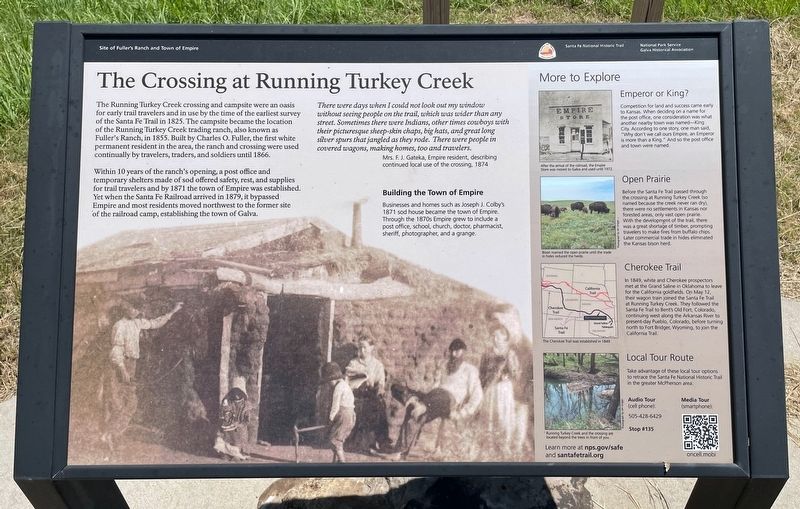
The Crossing at Running Turkey Creek
Site of Fuller's Ranch and Town of Empire
| — | Santa Fe National Historic Trail | — |
Photographed by Mark Hilton, July 1, 2024
1. The Crossing at Running Turkey Creek Marker
Within 10 years of the ranch's opening, a post office and temporary shelters made of sod offered safety, rest, and supplies for trail travelers and by 1871 the town of Empire was established.Yet when the Santa Fe Railroad arrived in 1879, it bypassed Empire and most residents moved northwest to the former site of the railroad camp, establishing the town of Galva.
There were days when I could not look out my window without seeing people on the trail, which was wider than any street. Sometimes there were Indians, other times cowboys with their picturesque sheep-skin chaps, big hats, and great long silver spurs that jangled as they rode. There were people in covered wagons, making homes, too and travelers.
Mrs. F. J. Gateka, Empire resident, describing continued local use of the crossing, 1874.
Building the Town of Empire
Businesses
this page online
photo captions:
Emperor or King?
Competition for land and success came early to Kansas. When deciding on a name for the post office, one consideration was what another nearby town was named-King City. According to one story, one man said, "Why don't we call ours Empire, an Emperor is more than a King." And so the post office and town were named.
After the arrival of the railroad, the Empire Store was moved to Galva and used until 1972.
Open Prairie
Before the Santa Fe Trail passed through the crossing at Running Turkey Creek (50 named because the creek never ran dry), there were no settlements in Kansas nor forested areas, only vast open prairie. With the development of the trail, there was a great shortage of timber, prompting travelers to make fires from buffalo chips. Later commercial trade in hides eliminated the Kansas bison herd.
Bison roamed the open prairie until the trade in hides reduced the herds.
Cherokee Trail
In

Photographed by Mark Hilton, July 1, 2024
2. The Crossing at Running Turkey Creek Marker
The Cherokee Trail was established in 1849.
Local Tour Route
Take advantage of these local tour options to retrace the Santa Fe National Historic Trail in the greater McPherson area
Running Turkey Creek and the crossing are located beyond the trees in front of you.
Erected by National Park Service, Galva Historical Association.
Topics and series. This historical marker is listed in this topic list: Settlements & Settlers. In addition, it is included in the Santa Fe Trail series list. A significant historical year for this entry is 1825.
Location. 38° 20.985′ N, 97° 31.163′ W. Marker is near Galva, Kansas, in McPherson County. It is on 22nd Avenue 1.9 miles south of U.S. 56, on the left when traveling south. Touch for map. Marker

Photographed by Mark Hilton, July 1, 2024
3. Fullers Ranch 1855
Nearby stone.
First White Settlement in Mc Pherson County

Regionally, this marker is in Central Kansas. It is also in the American Midwest, in the Corn Belt, on the prairies, on the Southern Plains, and on the Santa Fe Trail Corridor. Globally, it is in North America, the Western Hemisphere, the Western World, and the Anglosphere. Historically, it finds itself in what was once the Louisiana Purchase.
Other nearby markers. At least 8 other markers are within 9 miles of this marker, measured as the crow flies: Santa Fe Trail (here, next to this marker); History of "The Rock" (here, next to this marker); Last Built Carnegie Library (approx. 5.6 miles away); Veterans Memorial (approx. 6.8 miles away); Kansas Indian Treaty (approx. 7.1 miles away); Sora Kansas Creek (approx. 7.1 miles away); McPherson Opera House (approx. 8.1 miles away); One Main Place (approx. 8.1 miles away). Touch for a list and map of all markers in Galva.

Photographed by Mark Hilton, July 1, 2024
4. Running Turkey Creek Crossing sign
Credits. This page was last revised on March 27, 2026. It was originally submitted on July 5, 2024, by Mark Hilton of Montgomery, Alabama. This page has been viewed 509 times since then and 67 times this year. Photos: 1, 2, 3, 4. submitted on July 5, 2024, by Mark Hilton of Montgomery, Alabama.
