Colleville-sur-Mer in Calvados, Normandy, France — Western Europe
Normandy American Memorial
Photographed by J. Makali Bruton, June 6, 2024
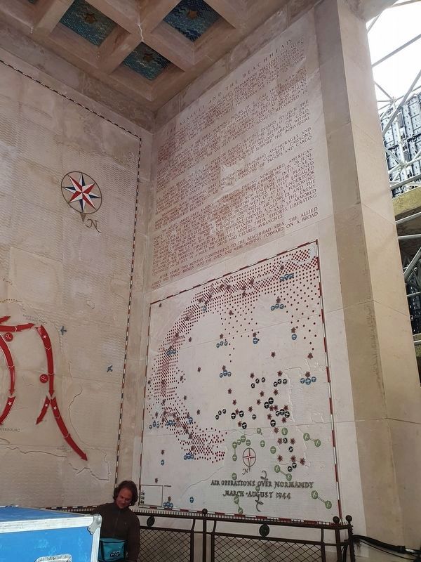
1. Normandy American Memorial - The Assault and the Beachhead
Below this inscription is a map entitled "Air Operations over Normandy, March - August, 1944." This inscription is on the southwest corner of the memorial.

Many months of planning and detailed preparation preceded the Allied landings in Normandy. The air bombardment to isolate the battlefield began in March 1944. During the next three months the Allied air forces, by systematically bombing bridges and rail centers, disrupted all forms of transportation between the Seine and the Loire; meanwhile strategic air operations were continued deep into enemy territory to compel the German Air Force to remain on the defensive.
In the darkness of the early morning hours of 6 June three airborne divisions (the British 6, the U.S. 82d and 101st) dropped beyond the beaches to destroy enemy forces and to cover the deployment of the seaborne assault troops. Simultaneously the Allied naval forces swept the English Channel of mines and preceded the assault vessels to the landing areas. At 0630 hours, under cover of naval gunfire and air bombardment, six U.S., British and Canadian divisions landed in the greatest amphibious assault recorded in history.
At Utah Beach, the U.S. 4th Division pushed rapidly inland to join the U.S. airborne divisions. At Omaha
this page online
Meanwhile, naval personnel were establishing temporary anchorages and artificial harbors by sinking ships and prefabricated concrete caissons. These expedients were of priceless aid in the unloading of troops and cargo over the unsheltered beaches.
The Allied armies grew rapidly in strength. Driving northward, American forces, aided by strong naval and air bombardment, freed Cherbourg on 26 June. On 9 July, the British and Canadians fought their way into Caen: nine days later U.S. units took St. Lo. The Allies could now unleash their planned attack to break out of the beachhead. While British forces heavily engaged the enemy on the Allied left flank, American troops west of St. Lo undertook the major effort to drive through the enemy defenses. On 25 July, following a paralyzing bombardment by the U.S. Eighth and Ninth Air Forces
Photographed by J. Makali Bruton, June 6, 2024
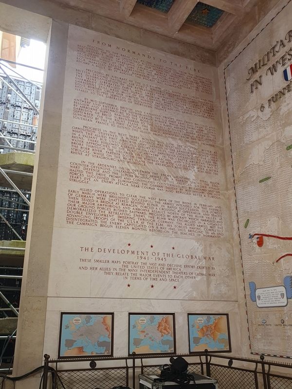
2. Normandy American Memorial - From Normandy to the Elbe
Below this inscription are three smaller maps which show the development of the war in Europe. This inscription is on the northwest wall of the memorial.
After nearly two months confinement to the beachhead area, the Allied armies had finally broken into the open and were moving forward on a broad front.
From Normandy to the Elbe
Reacting to the break-out by the Allied forces from the Normandy beachhead, the enemy launched a counteratack toward Avranches with the desperate hope of cutting of our advancing columns, but was repulsed with heavy losses. Thereupon, the American forces swung northward toward Argentan while at the same time the British and Canadians advance southward on Falaise, threatened with encirclement, the enemy turned back. Harassed by aircraft, hammered incessantly by artillery, his retreat became a rout. By 22 august, the pocket was eliminated.
Preceded by aircraft of the US Eighth and Ninth Air Forces and the British Second Tactical Air Force, whose constant
Photographed by J. Makali Bruton, June 6, 2024
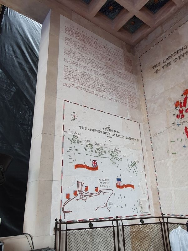
3. Normandy American Memorial - Le Debarquement en Normandie
Below the inscription is a map titled "6 June 1944, Amphibious Assault Landings." This inscription is on the southeast wall of the memorial.
By mid-September, British and Canadian troops had freed Brussels and Antwerp and entered the Netherlands. The U.S. First Army had swept across Belgium and Luxembourg to the German border, while the Third Army, aided by airborne supply, reached the Moselle in a rapid advance. In Brittany the garrison of Brest surrendered to the newly activated Ninth Army on 18 September. On the right flank the U.S. Seventh and French First Armies, supported by the U.S. First Tactical Air Force, advanced from the beaches of southern France to extend the Allied front solidly to the Swiss frontier.
Progress in the next three months was slow, the fighting bitter, as opposition stifferened.
Photographed by J. Makali Bruton, June 6, 2024
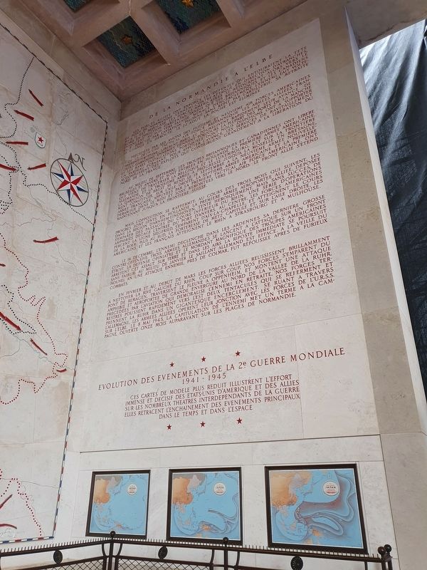
4. Normandy American Memorial - De la Normandie à l’Elbe
The map below the inscription details the evolution of the War in Asia and the Pacific. This inscription is on the northeast wall of the memorial.
In the Ardennes on 16 December the enemy launched his final major counter-offensive, unleashing three armies on a narrow front. The stalwart defense and the superb fighting skill of the American soldier finally halted this drive. Prompt and continuous countermeasures by ground and air forces succeeded in eliminating the German salient by mid-January. On New Year's Eve an enemy attack near Colmar was also repulsed after a furious struggle.
Allied operations to clear the west bank of the Rhine in February and early March were brilliantly successful,

Photographed by J. Makali Bruton, June 6, 2024
5. Normandy American Memorial - Normandy Beach Landings Map
This map is titled "The Landings on the Normandy Beaches & the Development of the Beachhead." It is on the southern wall of the memorial.
The Development of the Global War
1941 – 1945
These smaller maps portray the vast and decisive effort exerted by the United States of America and her allies in the many interdependent theaters of global war
They relate the major events to each other in terms of time and space
Le debarquement des allies en Normandie a exige de nombreux mois de mise au point minutieuse en mars 1944. Les forces aeriennes commencent
Photographed by J. Makali Bruton, June 6, 2024
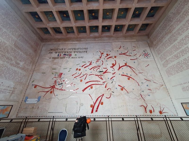
6. Normandy American Memorial - Military Operations in Western Europe Map
This map is titled "Military Operations in Western Europe, 6 June 1944 - 8 May 1945." It is on the northern wall of the memorial.
Le 6 juin, avant l’Aaube, trois divisions aeroportees, la 6eme division Britannique, les 82eme et 101eme divisions Americaines descendent du ciel derriere les plages pour couvrir le deploiement des troupes venuis par mer. A 6 heures 30 commence la plus grande attaque amphibie de l’histoire. Sous la protection du feu intense de la flotte et de laviation, six divisions americaines, britanniques et canadiennes gagnent la terre.
Sur la plage Utah, les 4eme division americaine pousse rapidement vers l’interieur. Sur le plage Omaha, les 1eme et 29eme divisions americaines avancent plus lentement: les combats sont plus durs et les pertes plus lourdes. Sur les plages Gold, Juno et Sword, les Britanniques et les Canadiens se frayent un chemin. Une semaine plus tard, avec l'appui incessant de la flotte et de l’aviation la soudure des tetes de

Photographed by J. Makali Bruton, June 6, 2024
7. Normandy American Memorial
This view shows the memorial after the 80th anniversary celebration of the D-Day landings. The inscriptions and maps are to the right and left of this semicircular colonnade. Some can be seen on the left through the columns.
Pendant ce temps, pour mettre a terre les troupes et le materiel, le personnel de la marine constitue des mouillages provisoires et des ports artificiels en coulant des navires et des caissons de beton specialement construits.
Les forces americaines poussent vers le nord et liberent Cherbourg le 26 juin. Les Britanniques et les Canadiens prennent Caen le 9 juillet; neuf jours plus tard, les forces americaines s’emparent de Saint Lo. Les Allies peuvent maintenant declencher l'attaque de rupture qu’ils ont soigneusement preparee. Tandis que, sur l'aile gauche, les forces britanniques prennent violemment l’offensive. Les americains exercent, a l'ouest de Saint-Lo, un effort decisif contre les defenses ennemies. Le 25 juillet, apres un bombardement aerien execute par les huitieme et neuvieme air forces americaines et la Royal Air Force, la premiere armee americaine ouvre une breche. Le 31 juillet Avranches est liberee.
Apres avoir ete enfermees pres de deux mois dans leurs tetes de apont, les armees alliees se sont enfin assurees le champ libre et avancent sur un large front.
De la Normandie à l’Elbe
Les forces

Photographed by Joerg Hagedorn, September 7, 2025
8. Normandy American Memorial
Précédées par des avions des huitieme et neuvieme Air Forces américaines et de la deuxième Tactical Air Force britannique les armees alliees franchissent la Seine, libérènt Paris et poursuivent rapidement leur avance de fortes garnisons nnemies tiennent toujours la plupart des ports de la Manche et les rares installations portuaires dont nous disposons ont a supporter un fardeau ecrasant. Pour appuyer l’avance, les services de ravitaillement accomplissent des exploits qui contribuent grandement a la liberation du nord de la France.
Au milieu de septembre, les troupes britanniques et canadiennes ont libéré Bruxelles et Anvers et sont entrees en Holland. La premier armee americaine,

Photographed by Joerg Hagedorn, August 7, 2025
9. Normandy American Memorial
Mais l’opposition se raffermit : au cours des trois mois qui suivent, les progrès sont lents. En Hollande la premiere armee aeroportee alliee, deposse dans la region d’Arnhem-Eindhoven, tente heroicamente, mais sans succes, de s’emparer des passages du cours inférieur du Rhin. Une serie d’opérations amphibies degage l’entree du port d’Anvers. Au centre, les forces américaines percent la ligne Siegfried, s’emparent d’Aix-la-Chapelle, et atteignent le cours de la Roer. Plus au sud, la forteresse de Metz capitule et, su l’aile droite, les Américains et les Français atteignent le Rhin à Strasbourg et a Mulhouse.
Le 16 décembre, l’ennemi declenche

Photographed by Joerg Hagedorn, September 7, 2025
10. Normandy American Memorial
En février et au début de mars les forces alliees reussissent brillamment a nettoyer la rive gauche du Rhin. Coup sur coup, nos forces s’emparent du pont de Remagen, traversent le fleuve a Oppenheim, et montent une attaque amphibie et aéroportée de grande envergue au nord de la vallée de la Ruhr. Nos forces terrestres pussent rapidement vers l’est deux tentacles qui se referment et prennent la Ruhr dans un gigantesque encerclement. Se ruant et travers l’Allemagen. Les armées alliées operent leur jonction avec les forces de l’U.R.S.S. sur l’Elbe. Le 8 mai 1945, la capitulation de l’ennemi met un terme a la campagne, ouverte onze mois auparavant sur les plages de Normandie.
Evolution des Evenments de la 2e Guerre Mondiale
1941 – 1945
Ces cartes de modele plus reduits illustrent l’effort immense et décisif des les États-Unis d’Amérique et des alliés sur les nombreux théâtres interdépendants de la guerre
Elles retracent l’enchainement des événements principaux dans le temps et dans l’espace
Topics. This memorial is listed in this topic list: War, World II. A significant historical month for this entry is March 1944.
Location. 49° 21.556′ N, 0° 51.201′ W. Memorial is in Colleville-sur-Mer, Normandie (Normandy), in Calvados. It can be reached from Route du Cimetiere Americain, on the left when traveling north. The memory is directly west of the visitors center at the Normandy American Cemetery and Memorial. Touch for map. Memorial is in this post office area: Colleville-sur-Mer, Normandie 14710, France. Touch for directions.

Regionally, it is in the North Atlantic Region, Europe, the European Union, Atlantic Europe, the Schengen Area, Western Europe, a coastal Mediterranean country, and the Western World. Historically, it finds itself in what was once a French colony and also the Roman Empire.
Other nearby markers. At least 8 other markers are within walking distance of this marker: Normandy American Cemetery and Memorial (about 90 meters away, measured in a direct line); General Dwight D. Eisenhower (about 150 meters away); Un point d'appui allemand, le WN 62 / The WN62, a German strong point (approx. 0.3 kilometers away); Normandy American Cemetery Chapel (approx. 0.4 kilometers away); The 1st Infantry Division (approx. 0.4 kilometers away); La Fontaine Saint-Clair / The Saint-Clair Fountain (approx. 1.1 kilometers away); Morts pour la Patrie / Fallen for the Fatherland (approx. 1.2 kilometers away); Bernard Anquetil (approx. 1.3 kilometers away). Touch for a list and map of all markers in Colleville-sur-Mer.
Also see . . . Normandy American Memorial 1987 booklet from the National Park Service. This 1987 document describes the memorial in great detail, including information on the materials used and the names of the architects and artists involved in its construction. (Submitted on July 6, 2024.)
Credits. This page was last revised on March 31, 2026. It was originally submitted on July 6, 2024, by J. Makali Bruton of Washington, District of Columbia. This page has been viewed 184 times since then and 27 times this year. Photos: 1, 2, 3, 4, 5, 6, 7. submitted on July 6, 2024, by J. Makali Bruton of Washington, District of Columbia. 8, 9, 10. submitted on March 26, 2026, by Joerg Hagedorn of Siegen, Germany.
Editor’s want-list for this marker. Wide view photos of the memorial. • Can you help?
