Albert Township in Lewiston in Montmorency County, Michigan — The American Midwest (Great Lakes)
Michelson & Hanson Saw Mill
Photographed by Joel Seewald, July 1, 2024
1. Michelson & Hanson Saw Mill Marker
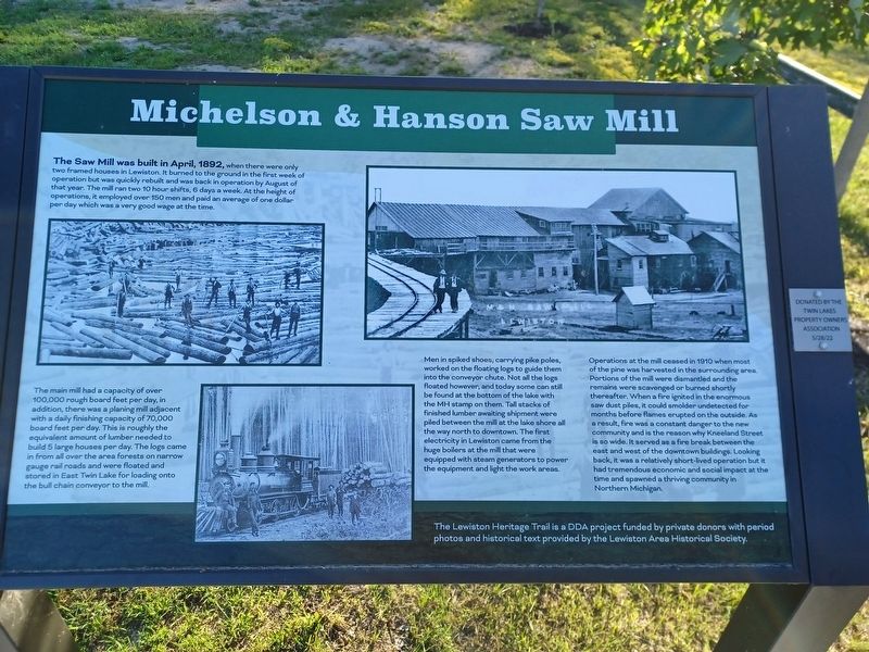
The Saw Mill was built in April, 1892, when there were only two framed houses in Lewiston. It burned to the ground in the first week of operation but was quickly rebuilt and was back in operation by August of that year. The mill ran two 10 hour shifts, 6 days a week. At the height of operations, it employed over 150 men and paid an average of one dollar per day which was a very good wage at the time.
The main mill had a capacity of over 100,000 rough board feet per day, in addition, there was a planning mill adjacent with a daily finishing capacity of 70,000 board feet per day. This is roughly the equivalent amount of lumber needed to build 5 large houses per day. The logs came in from all over the area forests on narrow gauge rail roads and were floated and stored in East Twin Lake for loading onto the bull chain conveyor to the mill.
Men in spiked shoes, carrying pike poles, worked on the floating logs to guide them into the conveyor chute. Not all the logs floated however, and today some can still be found at the bottom of the lake with the MH stamp on them. Tall stacks of finished lumber awaiting shipment were
this page online
Operations at the mill ceased in 1910 when most of the pine was harvested in the surrounding area. Portions of the mill were dismantled and the remains were scavenged or burned shortly thereafter. When a fire ignited in the enormous saw dust piles, it could smolder undetected for months before flames erupted on the outside. As a result, fire was a constant danger to the new community and is the reason why Kneeland Street is so wide. It served as a fire break between the east and west of the downtown buildings. Looking back, it was a relatively short-lived operation but it had tremendous economic and social impact at the time and spawned a thriving community in Northern Michigan.
The Lewiston Heritage Trail is a DDA project funded by private donors with period photos and historical text provided by the Lewiston Area Historical Society.
Donated by the Twin Lakes Property Owners Association
5/28/22
Erected 2022

Photographed by Joel Seewald, July 1, 2024
2. Michelson & Hanson Saw Mill Marker
Topics. This historical marker is listed in these topic lists: Disasters • Industry & Commerce. A significant historical month for this entry is April 1892.
Location. 44° 52.597′ N, 84° 18.337′ W. Marker is in Lewiston, Michigan, in Montmorency County. It is in Albert Township. It is at the intersection of Grant Drive and Kneeland Street, on the left when traveling west on Grant Drive. Marker is in Tom May Memorial Park. Touch for map. Marker is at or near this postal address: 4391 Grant Drive, Lewiston MI 49756, United States of America. Touch for directions.

Regionally, this marker is in Northern Michigan Lower Peninsula. It is also in the American Midwest. Globally, it is in North America, the Great North Woods, the Western Hemisphere, the Western World, and the Anglosphere. Historically, it finds itself in what was once the Northwest Territory.
Other nearby markers. At least 8 other markers are within walking distance of this marker: Early Recreation in Lewiston (approx. 0.3 miles away); Rail Roads in the Big Timber Era (approx. 0.3 miles away); The Quebec Hotel (approx. 0.4 miles away); Patty Welsh's Saloon (approx. 0.4 miles away); The Sachs Hardware Building (approx. 0.4 miles away); The Lewiston House (approx. 0.4 miles away); M & H Company Store and Offices (approx. 0.4 miles away); First Town Halls in Lewiston (approx. 0.4 miles away). Touch for a list and map of all markers in Lewiston.
Credits. This page was last revised on November 27, 2024. It was originally submitted on July 7, 2024, by Joel Seewald of Madison Heights, Michigan. This page has been viewed 497 times since then and 52 times this year. Photos: 1, 2. submitted on July 7, 2024, by Joel Seewald of Madison Heights, Michigan.
