Kirkendall South in Hamilton, Ontario — Central Canada (North America)
All Aboard!
The Brantford and Hamilton Electric Railway
Photographed by Tim Boyd, July 5, 2024
1. All Aboard! Marker
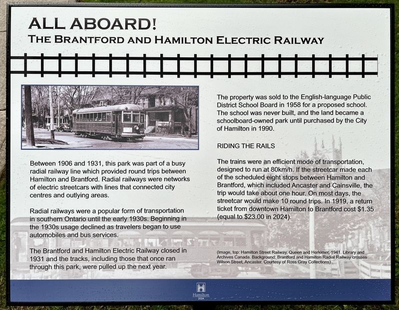
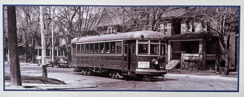
Radial railways were a popular form of transportation in southern Ontario until the early 1930s. Beginning in the 1930s usage declined as travelers began to use automobiles and bus services.
The Brantford and Hamilton Electric Railway closed in 1931 and the tracks, including those that once ran through this park, were pulled up the next year.
The property was sold to the English-language Public District School Board in 1958 for a proposed school. The school was never built, and the land became a schoolboard-owned park until purchased by the City of Hamilton in 1990.
Riding the Rails
The trains were an efficient mode of transportation, designed to run at 80km/h. If the streetcar made each of the scheduled eight stops between Hamilton and Brantford, which included Ancaster and Cainsville, the trip would take about one hour. On most days, the streetcar would make 10 round
this page online
Erected 2024 by City of Hamilton.
Topics. This historical marker is listed in this topic list: Railroads & Streetcars. A significant historical year for this entry is 1906.
Location. 43° 14.921′ N, 79° 53.043′ W. Marker is in Hamilton, Ontario. It is in Kirkendall South. It is at the intersection of Spruceside Avenue and Aberdeen Avenue, on the left when traveling south on Spruceside Avenue. Touch for map. Marker is at or near this postal address: 1 Spruceside Ave, Hamilton ON L8P 2P9, Canada. Touch for directions.

Regionally, this marker is on the Golden Horseshoe, in the Hamilton-Halton-Brant Area, and specifically in the Toronto Metropolitan Area. It is also in Central Canada. Globally, it is in North America, on the Great Lakes, in the Western Hemisphere, in the Western World, and in the Anglosphere. Historically, it finds itself in what was once a British colony, the Viceroyalty of New France, the Haudenosaunee (Iroquois) Confederacy, and Rupert’s Land.
Other nearby markers. At least 8 other markers

Photographed by Tim Boyd, July 5, 2024
2. All Aboard! Marker
Also see . . . Trainweb.org - The Brantford & Hamilton Electric Railway (B&H). The origin of the Brantford & Hamilton Electric Railway (B&H) is a decade long story that involves the entanglement of two separate companies, some name changes, and several rounds of incorporation, chartering, by-laws and takeovers. The story begins in January 1896 as a much smaller project named the Chedoke Park Hotel & Railway company. The CPH&R would have run a short distance between the head of Garth St (now Dundurn) and the corner of Herkimer & Queen,
3. All Aboard! marker photo detail
Credits. This page was last revised on July 13, 2024. It was originally submitted on July 11, 2024, by Tim Boyd of Hamilton, Ontario. This page has been viewed 210 times since then and 34 times this year. Photos: 1, 2, 3. submitted on July 11, 2024, by Tim Boyd of Hamilton, Ontario. • Andrew Ruppenstein was the editor who published this page.
