Bury St Edmunds in Suffolk, England, United Kingdom — Northwestern Europe (the British Isles)
The Cloister
| — | Bury St Edmunds Abbey | — |
Photographed by Ray Gurganus, March 27, 2024
1. The Cloister Marker
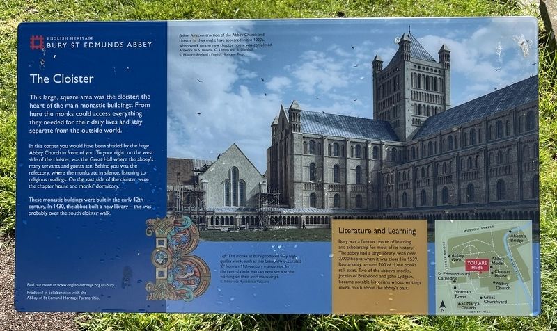
In this corner you would have been shaded by the huge Abbey Church in front of you. To your right, on the west side of the cloister, was the Great Hall where the abbey's many servants and guests ate. Behind you was the refectory, where the monks ate in silence, listening to religious readings. On the east side of the cloister were the chapter house and monks' dormitory.
These monastic buildings were built in the early 12th century. In 1430, the abbot built a new library-this was probably over the south cloister walk.
Literature and Learning
Bury was a famous centre of learning and scholarship for most of its history. The abbey had a large library, with over 2,000 books when it was closed in 1539. Remarkably, around 200 of those books still exist. Two of the abbey's monks, Jocelin of Brakelond and John Lydgate became notable historians whose writings reveal much about the abbey's past.
Erected by English Heritage.
this page online
Topics. This historical marker is listed in this topic list: Religion & Religious Structures. A significant historical year for this entry is 1439.
Location. 52° 14.643′ N, 0° 43.101′ E. Marker is in Bury St Edmunds, England, in Suffolk. It can be reached from Angel Hill. Touch for map. Marker is at or near this postal address: 2 Abbeygate Street, Bury St Edmunds, England IP33 1RS, United Kingdom. Touch for directions.

Regionally, this marker is in East Anglia. Globally, it is on the Atlantic Ocean, in the North Atlantic Region, in Europe, in Atlantic Europe, on one of the British Isles, in the Western World, and in the Anglosphere. Historically, it finds itself in what was once the Roman Empire.
Other nearby markers. At least 8 other markers are within walking distance of this marker: The Chapter House (within shouting distance of this marker); The Heart of the Church (within shouting distance of this marker); St Edmunds Abbey (within shouting distance of this marker); The Abbot's Palace (about 90 meters away, measured in a direct line); Cnut's Church and its Successor (about 90 meters away); The West Front (about 90

Photographed by Ray Gurganus, March 27, 2024
2. Bury St Edmunds Abbey Ruins
Credits. This page was last revised on July 13, 2024. It was originally submitted on July 12, 2024, by Ray Gurganus of Washington, District of Columbia. This page has been viewed 102 times since then and 8 times this year. Photos: 1, 2. submitted on July 12, 2024, by Ray Gurganus of Washington, District of Columbia. • Andrew Ruppenstein was the editor who published this page.
Editor’s want-list for this marker. photo of the marker within its surroundings • Can you help?
