Coronado in San Diego County, California — The American West (Pacific Coastal)
History of Golf in Coronado
Photographed by Col. James F. Jamison, USMC (Ret), July 12, 2024
1. History of Golf in Coronado Marker
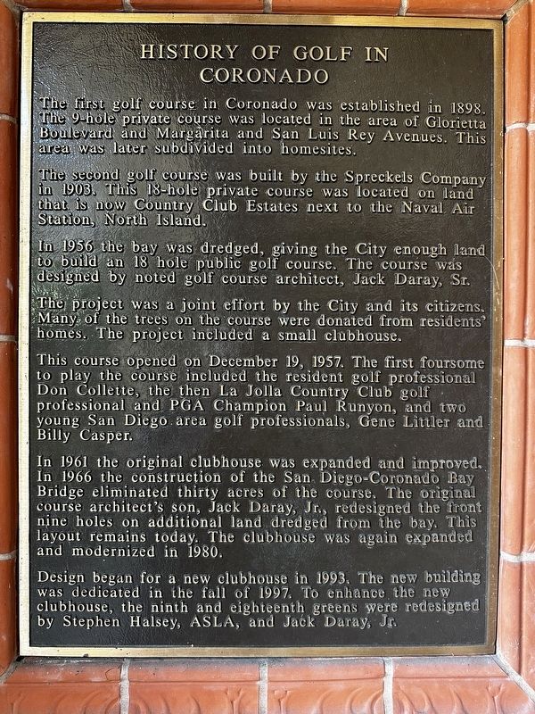
The first golf course in Coronado was established in 1898. The 9-hole private course was located in the area of Glorietta Boulevard and Margarita and San Luis Rey Avenues. This area was later subdivided into homesites.
The second golf course was built by the Spreckels Company in 1903. This 18-hole private course was located on land that is now Country Club Estates next to the Naval Air Station, North Island.
In 1956 the bay was dredged, giving the City enough land to build an 18 hole public golf course. The course was designed by noted golf course architect, Jack Daray, Sr.
The project was a joint effort by the City and its citizens. Many of the trees on the course were donated from residents' homes. The project included a small clubhouse.
This course opened on December 19, 1957. The first foursome to play the course included the resident golf professional Don Collette, the then La Jolla Country Club golf professional and PGA Champion Paul Runyon, and two young San Diego area golf professionals, Gene Littler and Billy Casper.
In 1961 the original clubhouse was expanded and improved. In 1966
this page online
Design began for a new clubhouse in 1993. The new building was dedicated in the fall of 1997. To enhance the new clubhouse, the ninth and eighteenth greens were redesigned by Stephen Halsey, ASLA, and Jack Daray, Jr.
Topics. This historical marker is listed in this topic list: Sports. A significant historical date for this entry is December 19, 1957.
Location. 32° 41.088′ N, 117° 9.967′ W. Marker is in Coronado, California, in San Diego County. It can be reached from Visalia Row. Marker is located outside of the front entrance of the Coronado golf course clubhouse on the left. It is not visible from the road. Touch for map. Marker is at or near this postal address: 2000 Visalia Row, Coronado CA 92118, United States of America. Touch for directions.

Regionally, this marker is in California’s Peninsular Ranges. It is also in the American

Photographed by Col. James F. Jamison, USMC (Ret), July 12, 2024
2. Clubhouse and Marker
Other nearby markers. At least 8 other markers are within walking distance of this marker: Carlin House - 1939 (approx. 0.3 miles away); San Diego-Coronado Bay Bridge (approx. 0.4 miles away); Seavey House - 1887 (approx. half a mile away); "Imagine Tent City" (approx. 0.6 miles away); J.D. Spreckels House - 1908 (approx. 0.7 miles away); The Naked Warrior (approx. 0.7 miles away); Sacred Heart Church - 1920 (approx. 0.7 miles away); The Oxford (approx. 0.7 miles away). Touch for a list and map of all markers in Coronado.
Credits. This page was last revised on March 16, 2026. It was originally submitted on July 14, 2024, by Col. James F. Jamison, USMC (Ret) of Coronado, California. This page has been viewed 216 times since then and 37 times this year. Photos: 1, 2. submitted on July 14, 2024, by Col. James F. Jamison, USMC (Ret) of Coronado, California. • Andrew Ruppenstein was the editor who published this page.
