
Springfield in Greene County, Missouri — The American Midwest (Upper Plains)
Lincoln School
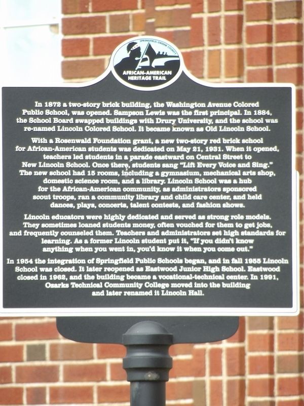
Photographed by Duane and Tracy Marsteller, March 21, 2019
1. Lincoln School Marker
With a Rosenwald Foundation grant, a new two-story red brick school for African-American students was dedicated on May 21, 1931. When it opened, teachers led students in a parade eastward on Central Street to New Lincoln School. Once there, students sang “Lift Every Voice and Sing.” The new school had 15 rooms, including a gymnasium, mechanical arts shop, domestic science room, and a library. Lincoln School was a hub for the African-American community, as administrators sponsored scout troops, ran a community library and child care center, and held dances, plays, concerts, talent contests, and fashion shows.
Lincoln educators were highly dedicated and served as strong role models. They sometimes loaned students money, often vouched for them to get jobs, and frequently counseled them. Teachers and administrators set high
this page online
In 1954 the integration of Springfield Public Schools began, and in fall 1955 Lincoln School was closed. It later reopened as Eastwood Junior High School. Eastwood closed in 1962, and the building became a vocational-technical center. In 1991, Ozarks Technical Community College moved into the building and later renamed it Lincoln Hall.
Erected by Springfield-Greene County African American Heritage Trail.
Topics and series. This historical marker is listed in these topic lists: African Americans • Education. In addition, it is included in the National Register of Historic Places (NRHP), and the Rosenwald Schools series lists. A significant historical date for this entry is May 21, 1931.
Location. 37° 12.995′ N, 93° 16.882′ W. Marker is in Springfield, Missouri, in Greene County. It is at the intersection of North Sherman Avenue and Bob Barker Boulevard, on the left when traveling north on North Sherman Avenue. Touch for map. Marker is at or near this postal address: 815 N Sherman Ave,
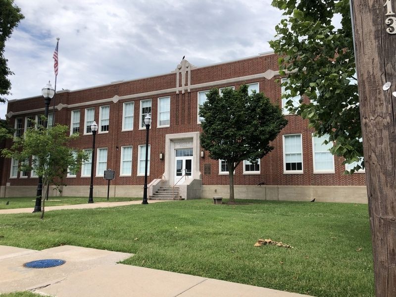
Photographed by Duane and Tracy Marsteller, June 29, 2024
2. Lincoln School Marker

Regionally, this marker is in the American Ozarks, in the Lewis & Clark Corridor, and in the Corn Belt. Globally, it is in North America, the Western Hemisphere, the Western World, and the Anglosphere. Historically, it finds itself in what was once the territory of the Mississippian Culture, the Louisiana Purchase, and the Antebellum South.
Other nearby markers. At least 8 other markers are within walking distance of this marker: Historic Washington Avenue Baptist Church (approx. ¼ mile away); Civil War Entrenchments (approx. 0.3 miles away); Graham’s Rib Station and Modern Motel Court (approx. 0.3 miles away); Stone Chapel (approx. 0.3 miles away); Benton Avenue A.M.E. Church (approx. 0.3 miles away); Fairbanks Hall (approx. 0.4 miles away); Church Square South (approx. 0.4 miles away); Tau Eta Gamma (local) (approx. 0.4 miles away). Touch for a list and map of all markers in Springfield.
Also see . . .
1. Lincoln School (Springfield, Missouri). Wikipedia entry on the historic school. (Submitted on July 14, 2024, by Duane and Tracy Marsteller of Murfreesboro, Tennessee.)
2. Lincoln School (PDF). National Register of Historic Places nomination for the school, which was listed in 2000. (Prepared by Katherine Lederer, Scott P. Myers and Steven E. Mitchell; via National Archives) (Submitted on July 14, 2024, by Duane and Tracy Marsteller of Murfreesboro, Tennessee.)
Credits. This page was last revised on July 14, 2024. It was originally submitted on July 14, 2024, by Duane and Tracy Marsteller of Murfreesboro, Tennessee. This page has been viewed 242 times since then and 34 times this year. Photos: 1, 2. submitted on July 14, 2024, by Duane and Tracy Marsteller of Murfreesboro, Tennessee.
