Burlington in Kit Carson County, Colorado — The American Mountains (Southwest)
The Winds of Change
Burlington Colorado
Photographed by Mark Hilton, July 2, 2024
1. The Winds of Change Marker
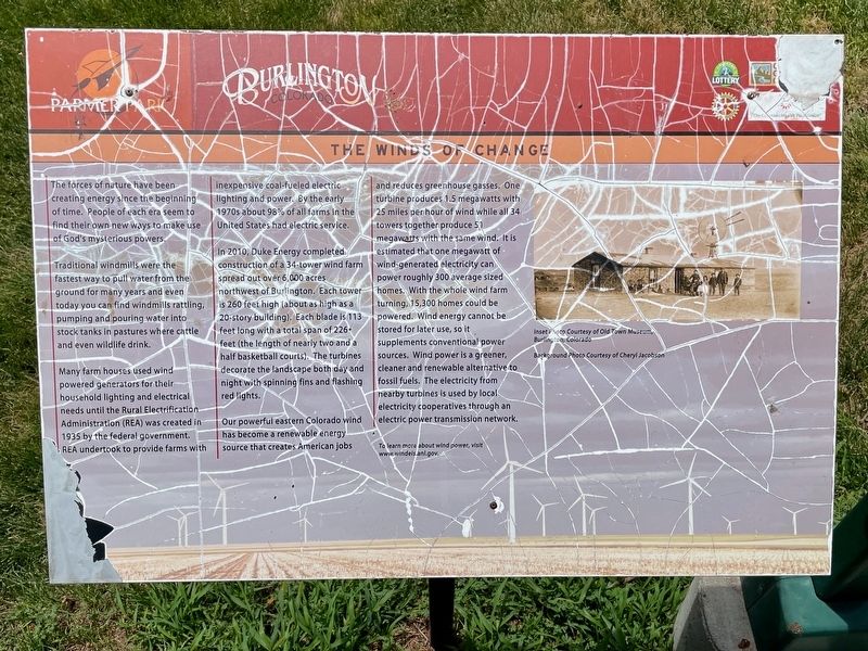
The forces of nature have been creating energy since the beginning of time. People of each era seem to find their own new ways to make use of God's mysterious powers.
Traditional windmills were the fastest way to pull water from the ground for many years and even today you can find windmills rattling, pumping and pouring water into stock tanks in pastures where cattle and even wildlife drink.
Many farm houses used wind powered generators for their household lighting and electrical needs until the Rural Electrification Administration (REA) was created in 1935 by the federal government. REA undertook to provide farms with inexpensive coal-fueled electric lighting and power. By the early 1970s about 98% of all farms in the United States had electric service.
In 2010, Duke Energy completed construction of a 34-tower wind farm spread out over 6,000 acres northwest of Burlington. Each tower is 260 feet high (about as high as a 20-story building). Each blade is 113 feet long with a total span of 226 feet (the length of nearly two and a half basketball courts). The turbines decorate the
this page online
Our powerful eastern Colorado wind has become a renewable energy source that creates American jobs and reduces greenhouse gasses. One turbine produces 1.5 megawatts with 25 miles per hour of wind while all 34 towers together produce 51 megawatts with the same wind. It is estimated that one megawatt of wind-generated electricity can power roughly 300 average sized homes. With the whole wind farm turning, 15,300 homes could be powered. Wind energy cannot be stored for later use, so it supplements conventional power sources. Wind power is a greener, cleaner and renewable alternative to fossil fuels. The electricity from nearby turbines is used by local electricity cooperatives through an electric power transmission network.
Erected by City of Burlington, Burlington Rotary Club, Great Outdoors Colorado, Colorado Health Foundation.
Topics and series. This historical marker is listed in this topic list: Natural Resources. In addition, it is included in the Rotary International series list. A significant historical year for this entry is 1935.
Location. 39° 17.725′ N,
Photographed by Mark Hilton, July 2, 2024
2. The Winds of Change Marker

Regionally, this marker is in the Eastern Plains. It is also in the American Mountain West, on the Great Plains, and specifically on the High Plains. Globally, it is in North America, the Western Hemisphere, the Western World, and the Anglosphere. Historically, it finds itself in what was once the Comanchería, the Dust Bowl, and the Louisiana Purchase.
Other nearby markers. At least 8 other markers are within walking distance of this marker: What Lies Beneath (a few steps from this marker); Farm Equipment - Then and Now (within shouting distance of this marker); A Farming Revolution (within shouting distance of this marker); As the Dust Settled (about 300 feet away, measured in a direct line); The Dust Bowl Years (about 400 feet away); What's In a Name (about 500 feet away); The Open Range (about 600 feet away); The Early People (about 700 feet away). Touch for a list and map of all markers in Burlington.
Credits. This page was last revised on July 19, 2024. It was originally submitted on July 19, 2024, by Mark Hilton of Montgomery, Alabama. This page has been viewed 162 times since then and 23 times this year. Photos: 1, 2. submitted on July 19, 2024, by Mark Hilton of Montgomery, Alabama.
