Tsentralnyy rayon in Sankt-Peterburg, Leningrad Oblast, Russia — Россия (Eastern Europe or Northern Asia)
1752, 1777 and 1788 Floods
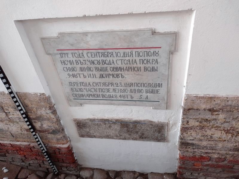
Photographed by Charles Berman, December 2, 2021
1. 1752, 1777 and 1788 Floods Marker

1752 года октября 23 дня пополудни въ 10 часу по зеленую линію выше ординарнои воды 8 футъ 5 д.
1788
this page online
In 1777 on September 10th at 7 at night, water stood at the red line, higher than normal by 9 feet 11 inches.
In 1752 on October 23rd at 10 o’clock in the daytime, at the green line, higher than normal water by 8 feet 5 in.
In 1788 on the 27th of September at 2 in the afternoon, water stood at the blue line above normal by 7 feet 6 inches.
Topics. This historical marker is listed in this topic list: Disasters. A significant historical date for this entry is September 10, 1777.
Location. 59° 56.723′ N, 30° 19.555′ E. Marker is in Sankt-Peterburg, Leningrad Oblast. It is in Tsentralnyy rayon. It is on Millionnaya Street. Touch for map. Marker is at or near this postal address: Millionnaya St 5/1, Sankt-Peterburg, Leningrad Oblast 19118-6, Russia. Touch for directions.

Regionally, it is in Europe and on the Pacific Rim. Historically, it finds itself in what was once the Soviet Union and also the Russian Empire.
Other nearby markers. At least 8 other markers are within 2 kilometers of this marker, measured as the crow flies: 1924 and 1975 Floods (here, next to this marker); 1824 Flood (here, next to this marker); Kulikov Vladimir Evgenievich (approx. 0.6 kilometers away); Carthouse (approx. 0.7 kilometers away in Sankt-Peterburg); Monument to Peter I (approx. 0.7 kilometers away); Platz-Mayorsky House (approx. 0.7 kilometers away); Shell traces (approx. 1.6 kilometers away); S. Shustov 19th Century Architecture (approx. 1.8 kilometers away). Touch for a list and map of all markers in Sankt-Peterburg.
Credits. This page was last revised on February 9, 2025. It was originally submitted on July 26, 2024, by Charles Berman of Binghamton, New York. This page has been viewed 107 times since then and 21 times this year. Photo 1. submitted on July 26, 2024, by Charles Berman of Binghamton, New York. • J. Makali Bruton was the editor who published this page.
