Hampton, Virginia — The American South (Mid-Atlantic)
1813 Landing of British Forces
Capture of Hampton
Photographed by Brandon D Cross
1. 1813 Landing of British Forces Marker
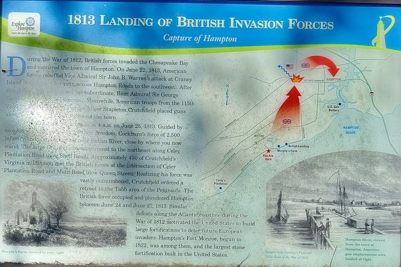
The British attack began at 4 A.M. on June 25, 1813. Guided by escaped slaves in exchange for their freedom. Cockburn’s force of 2,500 infantry and marines near Indian River, close by where you now stand. The large British force maneuvered to the northeast along Celey Plantation Road (now Shell Road). Approximately 450 of Crutchfield’s Virginia militiamen met the British forces at the intersection of Celey Plantation Road and Main Road (now Queen Street). Realizing his force was vastly outnumbered, Crutchfield ordered a retreat to the Tabb area of the Peninsula. The British force occupied and plundered
this page online
(captions)
Murphy's Farm, located to your right
Images from Lossing's Pictorial Field-Book of the War of 1812.
Hampton River, viewed from the town of Hampton. American gun emplacements were located at right.
Erected by Explore Hampton.
Topics. This memorial is listed in this topic list: War of 1812.
Location. 36° 59.99′ N, 76° 22.406′ W. Memorial is in Hampton, Virginia. It is at the intersection of Powhatan Parkway and Chesapeake Avenue, on the left when traveling north on Powhatan Parkway. Touch for map. Memorial is in this post office area: Hampton VA 23661, United States of America. Touch for directions.

Regionally, this memorial is on Virginia’s Peninsula and in Coastal Virginia. It is also in the American South, specifically in the Upper South,

Photographed by Brandon D Cross
2. 1813 Landing of British Forces Marker
Other nearby markers. At least 8 other markers are within walking distance of this marker: Indian River Park – In The Heart Of Olde Wythe (a few steps from this marker); Sack of Hampton / The War of 1812 (a few steps from this marker); The Hampton Roads Golf And Country Club (approx. ¼ mile away); Hampton Roads – World’s Greatest Harbor (approx. 0.3 miles away); Officer Kenneth Earl Wallace (approx. 0.3 miles away); Admiral Sir George Cockburn on the Chesapeake / The War of 1812 (approx. 0.3 miles away); Captain John C. Robinson (approx. 0.3 miles away); Olde Wythe During Colonial Times (approx. 0.4 miles away). Touch for a list and map of all markers in Hampton.
Also see . . . Battle of Hampton (1812). (Submitted on July 30, 2024, by Brandon D Cross of Flagler Beach, Florida.)
Credits. This page was last revised on July 31, 2024. It was originally submitted on July 30, 2024, by Brandon D Cross of Flagler Beach, Florida. This page has been viewed 343 times since then and 30 times this year. Photos: 1, 2. submitted on July 30, 2024, by Brandon D Cross of Flagler Beach, Florida. • Bernard Fisher was the editor who published this page.
