
Medical Mile in Grand Rapids in Kent County, Michigan — The American Midwest (Great Lakes)
Courthouse Clock Tower

Photographed by Joel Seewald, April 5, 2024
1. Courthouse Clock Tower Marker
This panel is on the south side of the clock tower, facing Lyon Street Northwest.
What is Significant About This Site?
[South side of tower, facing Lyon Street NW]
Grand Rapids
City Hall
1888-1969
On this site sat the former Grand Rapids City Hall from 1888 to 1969. With its majestic clock tower soaring above the Grand Rapids skyline, the commanding presence of City Hall made it a symbol of the city.
Image caption: Grand Rapids City Hall, designed by Elijah E. Myers. Watercolor rendering, c. 1884.
Kent County
Courthhouse
1892-1966
Less than a block away to the north and west-- near what is today City-County Plaza-- stood the 1892 Kent County Courthouse. Its distinctive red brick and stone, numerous decorative turrets, as well as its massive central tower made it a Grand Rapids landmark.
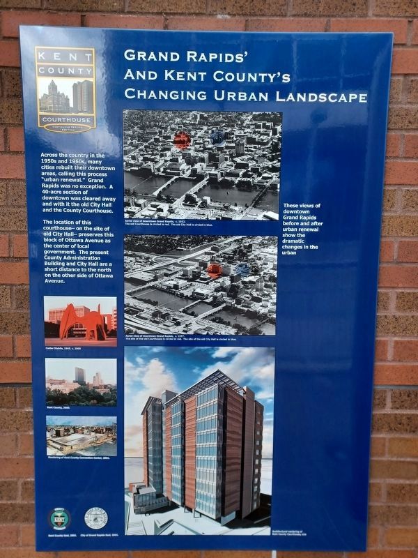
Grand Rapids' and Kent County's Changing Urban Landscape
[East side of tower, facing the courthouse]
Across the country in the 1950s and 1960s, many cities rebuilt their downtown areas, calling this process "urban renewal." Grand Rapids was no exception. A 40-acre section of downtown was cleared away and with it the old City Hall and the County Courthouse.
The location of this courthouse— on the
this page online
These views of downtown Grand Rapids before and after urban renewal show the dramatic changes in the urban
Top left image caption: Calder Stabile, 1969. c. 2000
Middle left image caption: Kent County, 2000.
Bottom left image caption: Rendering of Kent County Convention Center, 2001.
Top right image caption: Aerial view of downtown Grand Rapids, c. 1952. The old Courthouse is circled in red. The old City Hall is circled in blue.
Middle right image caption: Aerial view of downtown Grand Rapids, c. 1977. The site of the old Courthouse is circled in red. The site of the old City Hall is circled in blue.
Bottom right image caption: Architectural rendering of Kent County Courthouse, 2000
Bottom left images captions: Kent County Seal, 2001 [left], City of Grand Rapids Seal, 2001 [right].
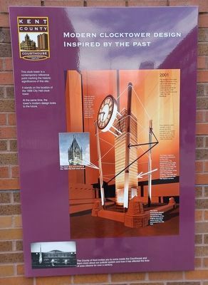
Modern Clocktower Design Inspired by the Past
[West side of marker, facing Ottawa Avenue NW]
This clock
Photographed by Joel Seewald, April 5, 2024
2. Courthouse Clock Tower Marker
Panel on the east side of the clock tower, facing the courthouse.
It stands on the location of the 1888 City Hall clock tower.
At the same time, the tower's modern design looks to the future.
2001
Image captions, clockwise from top right:
The deign of the tower reflects elements of the two former landmarks by incorporating architectural elements from both the 1892 County Courthouse and 1888 City Hall Buildings.
Four stainless steel turrets in each corner are tilted outward to symbolize the destruction of the towers and turrets on old City Hall and the 1892 Courthouse.
The tower masonry reflects the brickwork on the 2001 Courthouse. The placement of the walls, turrets, and the metal cables surrounding the turrets, echoes the interesting shape of the 2001 Courthouse building. The main part of the courthouse has few square corners.
The stone monuments placed around the tower are remnants of the original decorative stone border that surrounded the City Hall.
The clock face and turrets of the 1888 City Hall clock tower.
The iron clock face is one of the original clock faces from the old City
Photographed by Joel Seewald, April 5, 2024
3. Courthouse Clock Tower Marker
This panel is on the south side of the clock tower, facing Ottawa Avenue Northwest.
Bottom image caption: The County of Kent invites you to come inside the Courthouse and learn more about our judicial system and how it has affected the lives of area citizens for over a century.
Erected by Kent County Courthouse.
Topics. This historical marker is listed in this topic list: Notable Buildings. A significant historical year for this entry is 1888.
Location. 42° 58.045′ N, 85° 40.184′ W. Marker is in Grand Rapids, Michigan, in Kent County. It is in Medical Mile. It is at the intersection of Ottawa Avenue Northwest and Lyon Street Northwest, on the left when traveling south on Ottawa Avenue Northwest. Touch for map. Marker is at or near this postal address: 180 Ottawa Avenue Northwest, Grand Rapids MI 49503, United States of America. Touch for directions.

Regionally, this marker is in West Michigan. It is also in the American Midwest. Globally, it is in North America, the Western Hemisphere, the Western World, and the Anglosphere. Historically, it finds itself in what was once the Northwest Territory.
Other nearby markers. At least 8 other
Photographed by Craig Doda, October 12, 2024
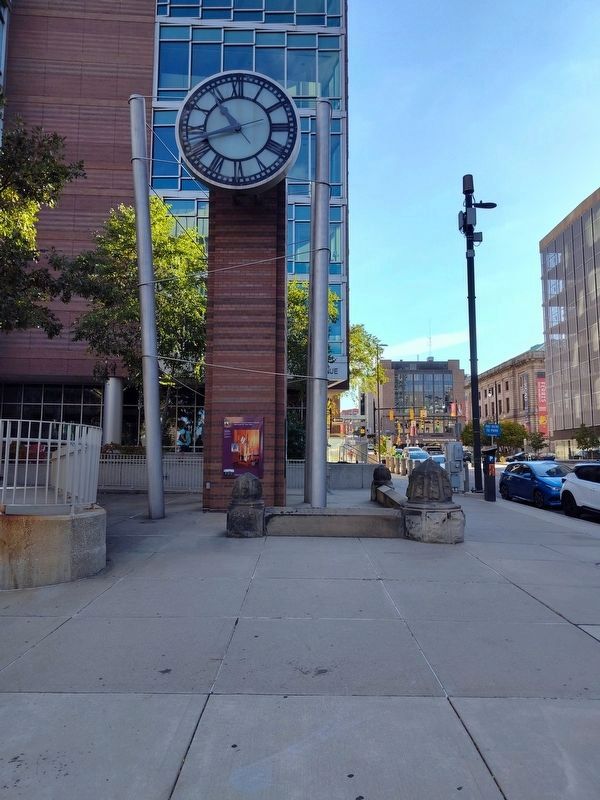
4. Courthouse Clock Tower
Credits. This page was last revised on October 17, 2024. It was originally submitted on July 31, 2024, by Joel Seewald of Madison Heights, Michigan. This page has been viewed 462 times since then and 127 times this year. Photos: 1, 2, 3. submitted on July 31, 2024, by Joel Seewald of Madison Heights, Michigan. 4. submitted on October 16, 2024, by Craig Doda of Napoleon, Ohio.
