Norwich in Norfolk, England, United Kingdom — Northwestern Europe (the British Isles)
St Peter Hungate
Photographed by Ray Gurganus, March 25, 2024
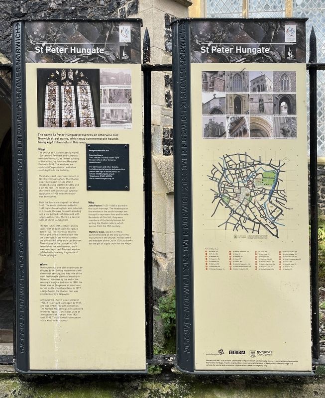
1. St Peter Hungate Marker
What
The church as it is now seen is mainly 15th century. The nave and transepts were totally rebuilt, as 'a neat building of black flint', by John and Margaret Paston in 1458. The windows are uniformly Perpendicular, and allow much light in to the building.
The chancel and tower were rebuilt in 1431 by Thomas Ingham. The Chancel was rebuilt again in 1604 after it collapsed. using plastered rubble and a pin-tile roof. The tower has been shortened, with an unusual pyramid cap put on in 1906 when the belfry was demolished.
Both the doors are original - of about 1460. The south porch was added in 1497, by Nicholas Ingham, who is buried in it. Inside, the nave has wall-arcading and a low pitched roof decorated with angels with scrolls. There is a central boss of Christ in Judgment.
The font is fifteenth-century, and its cover, with an open-work steeple, is dated 1605. There are two squints which give a view from the nave into the transepts. In the north transept the doors to
this page online
When
The church was one of the earliest to be affected by the Oxford Movement of the nineteenth century, and was 'one of the most fashionable places of worship in Norwich'. However by the end of the century it was in a bad way; in 1888, the tower was so dangerous an order was served on the churchwardens. In 1897. a large hole in the chancel roof was covered only by a tarpaulin.
Although the church was restored in 1906, it was in bad state again by 1931, and was threatened with demolition. The Norfolk Archaeological Trust raised money to repair, and it was used as a museum of church art from 1936 until 1995. This was the first museum of its kind, in the country.
Who
John Paston (1421-1466) is buried in the south transept. The headstops on the window in the south transept are thought to represent him and his wife. Residents of Elm Hill, they were members of the family famous for writing the Paston Letters, which survive from the 15th century.
Matthew Goss,

Photographed by Ray Gurganus, March 25, 2024
2. St Peter Hungate Church and Marker
Topics. This historical marker is listed in these topic lists: Architecture • Religion & Religious Structures. A significant historical year for this entry is 1458.
Location. 52° 37.861′ N, 1° 17.82′ E. Marker is in Norwich, England, in Norfolk. It is on Princes Street, on the left when traveling east. Touch for map. Marker is at or near this postal address: 11 Princes Street, Norwich, England NR3 1AZ, United Kingdom. Touch for directions.

Regionally, this marker is in East Anglia. Globally, it is on the Atlantic Ocean, in the North Atlantic Region, in Europe, in Atlantic Europe, on one of the British Isles, in the Western World, and in the Anglosphere. Historically, it finds itself in what was once the Roman Empire.
Other nearby markers. At least 8 other markers are within walking distance of this marker: United Reformed Church (a few steps from this marker); Elm Hill (within shouting distance of this marker); St Christopher's Church (within shouting distance of this marker); Paston House (within shouting distance of this marker); Wrights Court (about 120 meters away, measured in a direct line); Augustine Steward House (about 120 meters away); Edith Cavell (about 150 meters away); a different marker also named Elm Hill (about 150 meters away). Touch for a list and map of all markers in Norwich.
Credits. This page was last revised on August 1, 2024. It was originally submitted on August 1, 2024, by Ray Gurganus of Washington, District of Columbia. This page has been viewed 130 times since then and 14 times this year. Photos: 1, 2. submitted on August 1, 2024, by Ray Gurganus of Washington, District of Columbia. • Andrew Ruppenstein was the editor who published this page.
