Toluca in Marshall County, Illinois — The American Midwest (Great Lakes)
Devlin
⎯⎯⎯
Toluca Coal Mine Shaft Number 1
Photographed by Duane and Tracy Marsteller, July 6, 2024
1. Devlin/Toluca Coal Mine Shaft Number 1 Marker
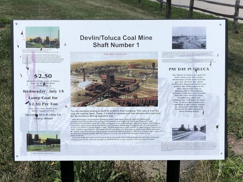
After Bennington Township was granted a switch and regular stop by Santa Fe Railroad the railroad hired Charles Devlin to prospect the area for coal needed for the steam-powered trains. It was then that mineral rights for 11,000 contiguous acres in Bennington, Bell Plain, Evans, and Roberts Townships were purchased by the Devlin Coal Company, founded by Charles Devlin. The development of new coal fields in Toluca began in 1892. The first goal was to sink shaft #1 beginning on February 9, 1893, and they were down to the lowest vein of coal, about 512 feet deep, by September of the same year. Mr. Devlin made a seemingly rash promise he would be able to produce 1,000 tons of coal a day in one year. He kept that promise and by 1895 the Toluca mine was one of the best equipped mines in the state of Illinois.
A second shaft was sunk one thousand feet to the south of the first shaft and the pair were connected underground.
this page online
[Captions]
• Top left: You are looking at the mining option from the west. Santa Fe Railroad's single rail is the foreground. The slag pile from shaft #1 is visible in the background on the right. Note in the photo of the Toluca mine during its operation there are no trees and no vegetation. After the mine closed in 1924 the vegetation slowly began naturally regenerating. From the time the mine closed in 1924 to March 1997 when the Toluca Coal Mine Preservation & Development Inc. was formed, the mine remained basically untouched. Slag piles of shale and nearly open shafts were left waiting for the fate of adventurous teens. During reclamation the shafts were safely filled and marked with state certified markers.
• Bottom left: Miners coming from work, Toluca, IL
• Top right: This photo was taken from shaft #2 looking north toward shaft #1 of the Toluca Coal Company. The slag pile at this time was just starting to form as you see an old Toluca water tower in the background. A dam on Crow Creek gave the mine the water it needed for the steam

Photographed by Duane and Tracy Marsteller, July 6, 2024
2. Devlin/Toluca Coal Mine Shaft Number 1 Marker
• Bottom right: Above main mine shaft #1 a tipple was erected. The huge tower was erected 60 feet above the mouth of the shaft which was surrounded by a covered platform. This platform was 30 feet above ground level. It was here that the coal was brought up and sorted by size. Each miner had a number which was stamped on small brass checks (pegs). As a miner filled a coal car, he attached the peg, the full car was weighed and recorded. The coal was sent to be sorted and washed. The miner was paid 75 cents per ton for the coal. The slag was tripped into another car which was attached to a cable and taken to the slag pile (making the Jumbo).
Topics. This historical marker is listed in these topic lists: Industry & Commerce • Natural Resources. A significant historical date for this entry is February 9, 1893.
Location. 40° 59.979′ N, 89° 8.07′ W. Marker is in Toluca, Illinois, in Marshall County. It can be reached from East Bennington Street 0.3 miles west of East Railroad Avenue, on the left when traveling west. Marker is in Toluca Coal Mine Park. Touch for map. Marker is at or near this postal address: 222 E Bennington St, Toluca IL 61369, United States of America. Touch for directions.

Regionally, this marker is in the Illinois River Valley and in Greater Peoria. It is also in the American Midwest and in the Corn Belt. Globally, it is in North America, the Western Hemisphere, the Western World, and the Anglosphere. Historically, it finds itself in what was once the territory of the Mississippian Culture and also the Northwest Territory.
Other nearby markers. At least 7 other markers are within 12 miles of this marker, measured as the crow flies: Santa Fe Railroad (here, next to this marker); Devlin/Toluca Coal Mine Fan Housing (a few steps from this marker); Toluca Coal Mine (within shouting distance of this marker); The Jumbo (within shouting distance of this marker); The Pool – A Community Gathering Point (about 400 feet away, measured in a direct line); Site of the first Clear Creek Friends Meeting House (approx. 11½ miles away); John Swaney School (approx. 11½ miles away).
Credits. This page was last revised on November 18, 2024. It was originally submitted on August 1, 2024, by Duane and Tracy Marsteller of Murfreesboro, Tennessee. This page has been viewed 457 times since then and 77 times this year. Photos: 1, 2. submitted on August 1, 2024, by Duane and Tracy Marsteller of Murfreesboro, Tennessee.
