Reading in Berkshire, England, United Kingdom — Northwestern Europe (the British Isles)
A Church on a Huge Scale
Abbey Quarter
Photographed by Ray Gurganus, April 1, 2024
1. A Church on a Huge Scale Marker
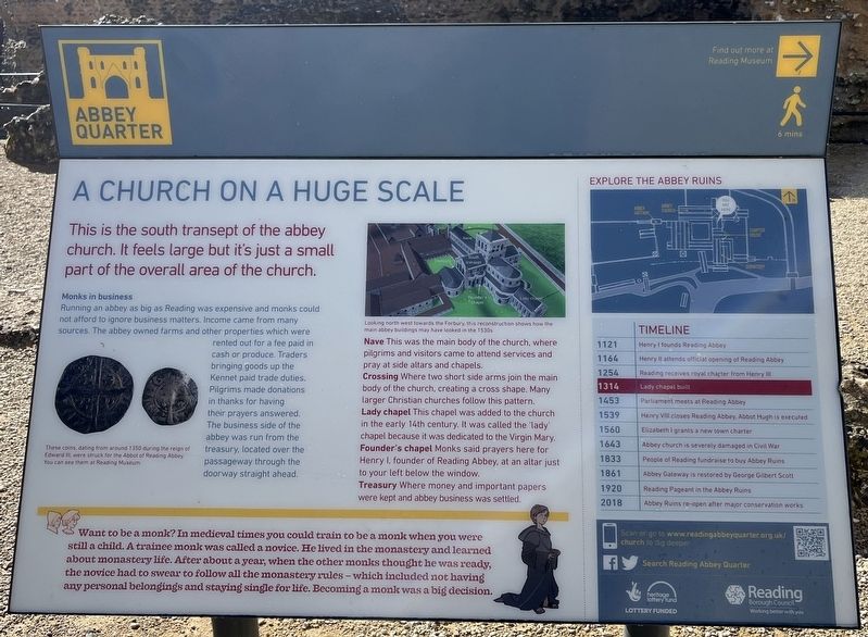
Monks in business
Running an abbey as big as Reading was expensive and monks could not afford to ignore business matters. Income came from many sources. The abbey owned farms and other properties which were rented out for a fee paid in cash or produce. Traders bringing goods up the Kennet paid trade duties. Pilgrims made donations in thanks for having their prayers answered. The business side of the abbey was run from the treasury, located over the passageway through the doorway straight ahead.
Nave - This was the main body of the church, where pilgrims and visitors came to attend services and pray at side altars and chapels.
Crossing - Where two short side arms join the main body of the church, creating a cross shape. Many larger Christian churches follow this pattern.
Lady Chapel - This chapel was added to the church in the early 14th century. It was called the 'lady' chapel because it was dedicated to the Virgin Mary.
Founder's chapel - Monks said prayers here for Henry I, founder of
this page online
Treasury - Where money and important papers were kept and abbey business was settled.
Want to be a monk? In medieval times you could train to be a monk when you were still a child. A trainee monk was called a novice. He lived in the monastery and learned about monastery life. After about a year, when the other monks thought he was ready, the novice had to swear to follow all the monastery rules-which included not having any personal belongings and staying single for life. Becoming a monk was a big decision.
Timeline
1121 - Henry I founds Reading Abbey
1164 - Henry II attends official opening of Reading Abbey
1254 - Reading receives royal charter from Henry III
1453 - Parliament meets at Reading Abbey
1539 - Henry VIII closes Reading Abbey. Abbot Hugh is executed
1560 - Elizabeth grants a new town charter
1643 - Abbey church is severely damaged in Civil War
1833 - People of Reading fundraise to buy Abbey Ruins
1840 - St James Church opens in former abbey grounds
1861 - Abbey Gateway is restored by George Gilbert Scott
1920 - Reading Pageant in Abbey Ruins
2018
Photographed by Ray Gurganus, April 1, 2024
2. Abbey Ruins
Erected by Reading Borough Council.
Topics. This historical marker is listed in this topic list: Religion & Religious Structures. A significant historical year for this entry is 1121.
Location. 51° 27.395′ N, 0° 57.908′ W. Marker is in Reading, England, in Berkshire. It can be reached from no nearby street. Touch for map. Marker is in this post office area: Reading, England RG1 3HW, United Kingdom. Touch for directions.

Regionally, this marker is in the Greater South East. Globally, it is on the Atlantic Ocean, in the North Atlantic Region, in Europe, in Atlantic Europe, on one of the British Isles, in the Western World, and in the Anglosphere. Historically, it finds itself in what was once the Roman Empire.
Other nearby markers. At least 8 other markers are within walking distance of this marker: Choir and Altar (a few steps from this marker); Abbey Quarter (a few steps from this marker); Chapter and Verse (within shouting distance of this marker); At the Heart of the Abbey (within shouting distance of this marker); You've Found the Abbey Ruins (within shouting distance of this marker); In the Warm (within shouting distance of this marker); You've Found the Abbey Wharf (about 90 meters away, measured in a direct line); Ground Level (about 90 meters away). Touch for a list and map of all markers in Reading.
Credits. This page was last revised on June 18, 2026. It was originally submitted on August 4, 2024, by Ray Gurganus of Washington, District of Columbia. This page has been viewed 197 times since then and 19 times this year. Photos: 1, 2. submitted on August 4, 2024, by Ray Gurganus of Washington, District of Columbia. • Andrew Ruppenstein was the editor who published this page.
