Port Stanley in Elgin County, Ontario — Central Canada (North America)
The Telegraph Office and the Traction Line
Photographed by Tim Boyd, July 27, 2024
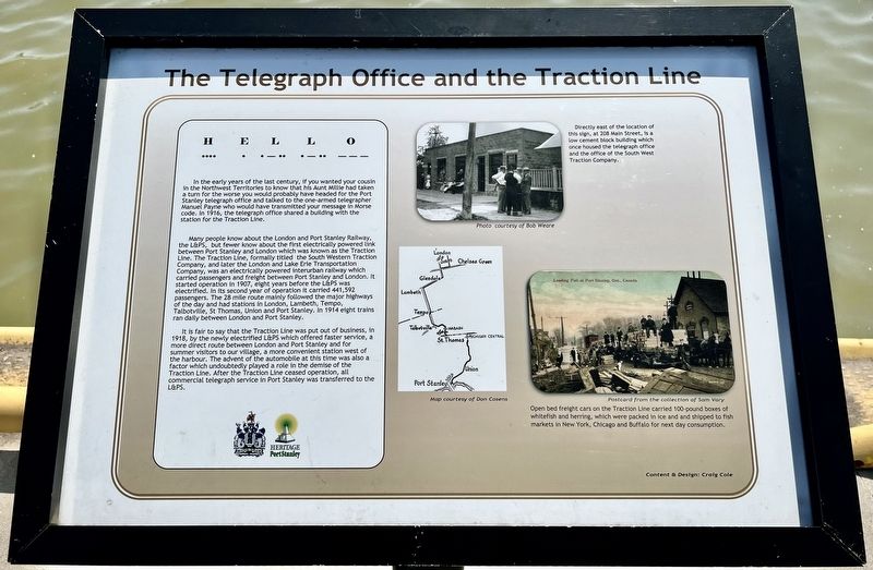
1. The Telegraph Office and the Traction Line Marker
H E L L O
.... . ._.. ._.. _ _ _
In the early years of the last century, if you wanted your cousin in the Northwest Territories to know that his Aunt Millie had taken a turn for the worse you would probably have headed for the Port Stanley telegraph office and talked to the one-armed telegrapher Manuel Payne who would have transmitted your message in Morse code. In 1916, the telegraph office shared a building with the station for the Traction Line.
Many people know about the London and Port Stanley Railway, the L&PS, but fewer know about the first electrically powered link between Port Stanley and London which was known as the Traction Line. The Traction Line, formally titled the South Western Traction Company, and later the London and Lake Erie Transportation Company, was an electrically powered interurban railway which carried passengers and freight between Port Stanley and London. It started operation in 1907, eight years before the L&PS was electrified. In its second year of operation it carried 441,592 passengers. The 28 mile route mainly followed the major highways of the day and had stations in London, Lambeth, Tempo, Talbotville, St Thomas, Union and Port Stanley. In 1914 eight trains ran daily between London
this page online
It is fair to say that the Traction Line was put out of business, in 1918, by the newly electrified L&PS which offered faster service, a more direct route between London and Port Stanley and for summer visitors to our village, a more convenient station west of the harbour. The advent of the automobile at this time was also a factor which undoubtedly played a role in the demise of the Traction Line. After the Traction Line ceased operation, all commercial telegraph service in Port Stanley was transferred to the L&PS.
Erected by Heritage Port Stanley.
Topics. This historical marker is listed in these topic lists: Communications • Railroads & Streetcars. A significant historical year for this entry is 1907.
Location. 42° 39.91′ N, 81° 12.792′ W. Marker is in Port Stanley, Ontario, in Elgin County. It is on Bridge Street, on the right when traveling east. The marker is near Glover Park on the east side of Kettle Creek, about 100M south of Bridge Street. Touch for map. Marker is at or near this postal address: 302 Bridge St, Port Stanley ON N5L 1C3, Canada. Touch for directions.

Regionally, this marker is in the Southwest Ontario Area and in Southwestern Ontario. It is also in Central Canada. Globally, it is in North

Photographed by Tim Boyd, July 27, 2024
2. The Telegraph Office and the Traction Line Marker
Other nearby markers. At least 8 other markers are within 11 kilometers of this marker, measured as the crow flies: Commemoration of Port Stanley Harbour (within shouting distance of this marker); Bridges (within shouting distance of this marker); The London and Port Stanley Railroad / Le Chemin de Fer London and Port Stanley (about 90 meters away, measured in a direct line); Port Stanley (about 120 meters away); Lieut.-Col. John Bostwick (approx. 0.6 kilometers away); Col. John Bostwick (approx. 0.6 kilometers away); RCAF Technical Training School / L’École de Formation de L’Aviation Royale du Canada (approx. 8.4 kilometers away); RCAF No. 4 Bombing and Gunnery School (approx. 10.2 kilometers away). Touch for a list and map of all markers in Port Stanley.
Also see . . . The South Western Traction Company/London & Lake Erie Company history.
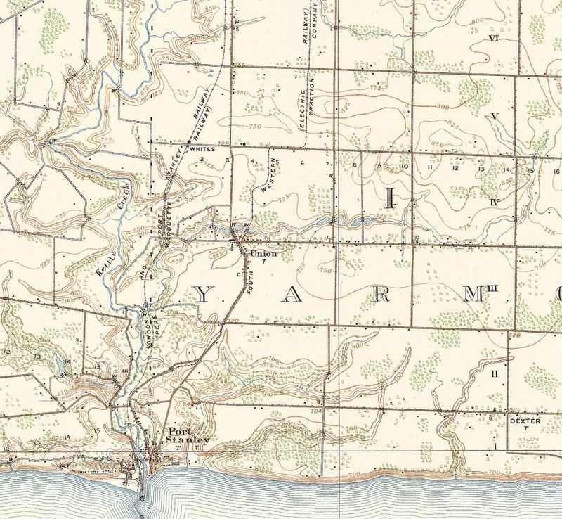
In early 1902, The London Railway Company was formed to obtain a charter to build an electric railway out of London, Ontario. By August(Submitted on August 5, 2024, by Tim Boyd of Hamilton, Ontario.)of 1902, the company had been renamed the South Western Traction Company and a charter was granted by the Ontario legislature. The SWT was intended to primarily be a passenger carrier, with little emphasis on heavy freight service. The line planned to build outward from London, west to the village of Strathroy via Delaware and Mt. Brydges. Plans were also in place to build branches eastward to the villages of Ingersoll via Nilestown, Dorchester and Putnam; London to Brantford and from London to Woodstock. The eventual goal was a connection with the City of Hamilton. In June of 1903, the South Western Traction company took over the 1902 charter of the Middlesex and Elgin Interurban railway. The latter company having completed a few surveys, but hadn't laid any track. The revised charter added additional lines south from London through St. Thomas to Port Stanley, as well as branches to Aylmer. Only the 28 miles between London to Port Stanley would ever be completed.19103. Topographic map of Port Stanely, 1910, showing the South Western Traction Co. Electric Railway

Photographed by John Valentine and Son, 1910
4. Postcard of a Traction Line bridge in St. Thomas, c.1910
(public domain)
Credits. This page was last revised on August 5, 2024. It was originally submitted on August 5, 2024, by Tim Boyd of Hamilton, Ontario. This page has been viewed 154 times since then and 37 times this year. Photos: 1, 2, 3, 4. submitted on August 5, 2024, by Tim Boyd of Hamilton, Ontario. • Andrew Ruppenstein was the editor who published this page.
