
Smiths Falls in Lanark County, Ontario — Central Canada (North America)
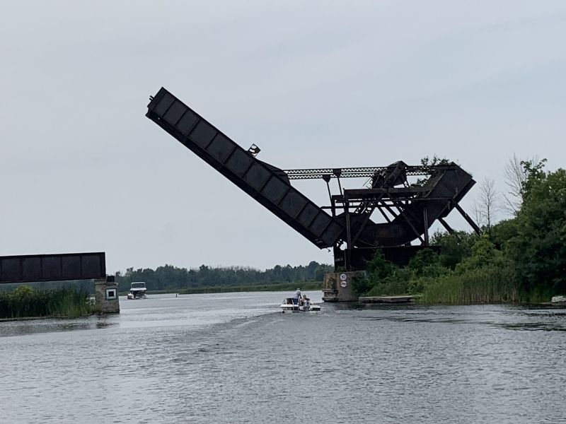
Smiths Falls Bascule Bridge
Le Pont Basculant de Smiths Falls

Photographed by John P Gauthier, August 3, 2024
1. Smiths Falls Bascule Bridge Marker

This Scherzer Rolling Lift bascule bridge is an outstanding early example of a novel concept in movable bridges, developed by William Scherzer, an American engineer. It combines the balanced counterweight of a conventional bascule bridge, with a unique rolling lift motion that all but eliminates friction. Erected in 1912-1913 to carry the Canadian Northern Railway main line across the Rideau Canal, a busy steamboat navigation system, the bridge was renowned for its ease and speed of operation, proving the efficacy of the concept.
Voici un excellent exemple des tout premiers ponts basculants de type Scherzer, érigé selon un concept fort remarquable développé par l'ingénieur américain William Scherzer. L'ouvrage allie le contrepoids aérien d'un pont basculant conventionnel à un mécanisme de roulement exceptionnel qui élimine pratiquement toute friction. Construit en 1912 et 1913 par le chemin de fer Canadien du Nord pour franchir le canal Rideau, une voie de navigation fortement achalandée à l'époque, le pont était renommé pour son fonctionnement
this page online
Erected 2002 by Historic Sites and Monuments Board of Canada.
Topics and series. This historical marker is listed in these topic lists: Bridges & Viaducts • Railroads & Streetcars. In addition, it is included in the Canada, Historic Sites and Monuments Board series list. A significant historical year for this entry is 1912.
Location. 44° 53.758′ N, 76° 1.661′ W. Marker is in Smiths Falls, Ontario, in Lanark County. It can be reached from Abbott Street North, on the left when traveling north. Marker located on northwest end of Smiths Falls Detached Lock (Rideau Canal lock #31). Touch for map. Marker is at or near this postal address: 8 Abbott St N, Smiths Falls ON K7A 5K2, Canada. Touch for directions.

Regionally, this marker is in the Haliburton Highlands to Ottawa Valley and in Eastern Ontario. It is also in Central Canada. Globally, it is in North America, the Western Hemisphere, the Western World, and the Anglosphere. Historically, it finds itself in what was once a British colony, the Viceroyalty of New France, the Haudenosaunee (Iroquois) Confederacy,
Photographed by John P Gauthier, August 3, 2024
2. Smiths Falls Bascule Bridge Marker
Other nearby markers. At least 8 other markers are within walking distance of this marker: Evergreen Avenue (approx. 0.3 kilometers away); World War I Memorial (approx. 0.3 kilometers away); Veterans Memorial (approx. 0.3 kilometers away); The Rideau Waterway (approx. 0.4 kilometers away); Grant Amy (approx. 0.4 kilometers away); Smiths Falls and the Dam / Smiths Falls et le Barrage (approx. 0.4 kilometers away); Water Works / Station de Production d'Eau Potable (approx. 0.4 kilometers away); Centennial Park (approx. 0.4 kilometers away). Touch for a list and map of all markers in Smiths Falls.
Credits. This page was last revised on January 4, 2025. It was originally submitted on August 6, 2024, by John P Gauthier of Belleville, Ontario. This page has been viewed 305 times since then and 62 times this year. Photos: 1, 2. submitted on August 6, 2024, by John P Gauthier of Belleville, Ontario. • Andrew Ruppenstein was the editor who published this page.
