
Hereford in Herefordshire, England, United Kingdom — Northwestern Europe (the British Isles)
Hereford Cathedral Close

Photographed by Ray Gurganus, April 6, 2024
1. Hereford Cathedral Close Marker
Demolished Houses
The four 19th century houses at the south end of Broad Street, which hid the view of the Cathedral from the west, were demolished in 1935 following a fare. By the early 20th century, they were occupied by tenants of the Dean and Chapter.
At the time of demolition the premises were, from left to right, a ladies hairdresser; a boarding house (previously the Globe Inn), a saddler and a land agent's office.
The Appletree
The mosaic takes the form of a huge apple tree encircled by words from Joshua Smith's 18th-century New England carol "Jesus Christ the Apple Tree", reminding us that Jesus is always in our midst. The apple symbolises Herefordshire, its people, and our long tradition of cider making, with the Cathedral's great Norman arches reflected in the upper design of the tree. The boughs also include visual reference to the Cross of Christ, the Crown of Thorns, and the Twelve Apostles, represented by the apples themselves. The outer circle, a symbol of eternity, is constructed in Forest of Dean sandstone. The apples are cut from red, green, and amber coloured stone, are inspired by varieties with
this page online
West Front
The Norman west end of the Cathedral, built around 1300, was surmounted by a tower in the Decorated style. By the 18th century, it had become decayed and unsafe and its spectacular collapse around 7pm on Easter Monday 1786 took with it the last two bays of the nave seriously damaging more of the cathedral structure. James Wyatt, a leading architect of the day, appointed by the Dean and Chapter to design a replacement.
Owing to financial considerations, he was also instructed to shorten the nave by one bay. Although Wyatt's gothic west front of 1790 was approved in its day. It quickly fell out of fashion and was replaced by the present structure, built to a design by the architect Oldrid Scott and completed in l908.
New Library Building, Mappa Mundi and Chained Library
The New Library building, designed by Whitfield and Partners, was completed in 1996 and opened by the Queen. The award winning budding provides
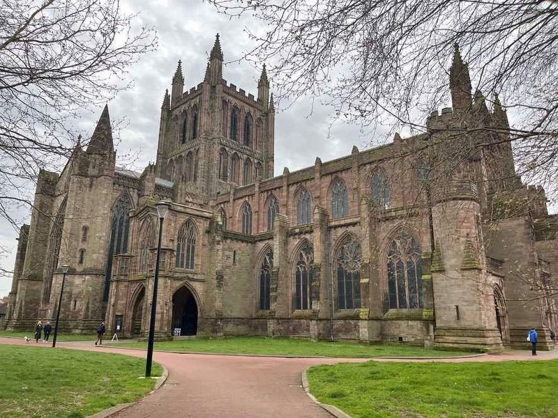
Photographed by Ray Gurganus, April 6, 2024
2. Hereford Cathedral
Topics. This historical marker is listed in these topic lists: Architecture • Arts, Letters, Music • Religion & Religious Structures.
Location. 52° 3.284′ N, 2° 43.031′ W. Marker is in Hereford, England, in Herefordshire. It is on King Street, on the left when traveling south. Touch for map. Marker is at or near this postal address: 5 King Street, Hereford, England HR4 9BJ, United Kingdom. Touch for directions.

Regionally, this marker is in England’s Midlands. It is also on the British Marches. Globally, it is on the Atlantic Ocean, in the North Atlantic Region, in Europe, in Atlantic Europe, on one of the British Isles, in the Western World, and in the Anglosphere. Historically, it finds itself in what was once the Roman Empire.
Other nearby markers. At least 7 other markers are within 21 kilometers of this marker, measured as the crow flies: A different marker also named Hereford Cathedral Close (within shouting distance of this marker); a different marker also named Hereford Cathedral Close (about 150 meters away, measured in a direct line); Wye Bridge (approx. 0.3 kilometers away); Rev. John Venn, M.A. (approx. 0.6 kilometers away); Hereford Train Station (approx. one kilometer away); a different marker also named Hereford Train Station (approx. one kilometer away); Red Crosse Bridge (approx. 19.5 kilometers away).
Credits. This page was last revised on August 10, 2024. It was originally submitted on August 8, 2024, by Ray Gurganus of Washington, District of Columbia. This page has been viewed 185 times since then and 21 times this year. Photos: 1, 2. submitted on August 8, 2024, by Ray Gurganus of Washington, District of Columbia. • Andrew Ruppenstein was the editor who published this page.
Editor’s want-list for this marker. photo of the marker within its surroundings • Can you help?
