Natural Bridge in Rockbridge County, Virginia — The American South (Mid-Atlantic)
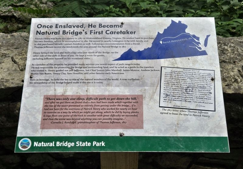
Once Enslaved, He Became Natural Bridge's First Caretaker
Photographed by Bradley Owen, August 12, 2024
1. Once Enslaved, He Became Natural Bridge's First Caretaker Marker
Patrick Henry was born into slavery in 1787 in Westmoreland County, Virginia. He worked hard to purchase his own freedom, which he accomplished in 1811. He moved to nearby Lexington to be with family, and in 1816 purchased his wife Louisa's freedom as well. Following a recommendation from a friend, Thomas Jefferson rented the newlyweds the area around the Natural Bridge in 1817.
Henry farmed the land and built a log cabin just north of the Bridge, on the other side of the cliffs in front of you. He kept a room for guests, including Jefferson himself on his occasional visits.
As caretaker of the property he provided many services you would expect of park rangers today. He was responsible for protecting the Bridge and surrounding land, and he acted as a guide to the travelers who visited it. Henry guided not just Jefferson, but Chief Justice John Marshall, James Monroe, Andrew Jackson, Martin Van Buren, Henry Clay, Sam Houston, and other famous early Americans.
Born in bondage, he held the key to one of the natural wonders of the world. A true trailbalzer, his stewardship of the Bridge helped make it the site it
this page online
(Sidebar):
"There was only one steep, difficult path to get down the hill, and after we got there we found that a dam had been made which together with the rise of the water prevented us entirely from getting under the bridge... if it had not been for the exertions of Patrick Henry who worked for nearly an hour to contrive us a way by which we might get along, which he did by laying planks & logs from one point of the rock to another with great difficulty we succeeded, and then the scene was beyond anything you can possibly imagine..."
-Cornelia J. Randolph, granddaughter of Thomas Jefferson, 1817
(Caption):
The 1817 letter where Thomas Jefferson agreed to lease the land to Patrick Henry.
Erected by Natural Bridge State Park.
Topics and series. This historical marker is listed in these topic lists: African Americans • Industry & Commerce. In addition, it is included in the Former U.S. Presidents: #03 Thomas Jefferson series list. A significant historical year for this entry is 1787.
Location. 37° 37.701′ N, 79° 32.711′ W. Marker is in Natural Bridge, Virginia, in Rockbridge County. It can be reached from the intersection of South Lee Highway (U.S. 11) and Rockbridge Road (Virginia Route 130), on the left when traveling south. Marker is located in Natural Bridge State Park along the Cedar Creek Trail. Touch for map. Marker is at or near this postal address: 6477 South Lee Highway, Natural Bridge VA 24578, United States of America. Touch for directions.

Regionally, this marker is in the Mountain Region. It is also in the American South, specifically in the Upper South, in Appalachia, and specifically in Southern Appalachia. Globally, it is in North America, the Western Hemisphere, the Western World, and the Anglosphere. Historically, it finds itself in what was once the territory of the Mississippian Culture, one of the original Thirteen Colonies, one of the Confederate States of America, and the Antebellum South.
Other nearby markers. At least 8 other markers are within walking distance of this marker: “The Most Sublime of Nature’s Works” (within shouting distance of this marker); How Did It Happen? (about 500 feet away, measured in a direct line); Natural Bridge Patent (about 600 feet away); “Vires-Acquirit-Eundo” Ancient Arbor Vitae (about 600 feet away); a different marker also named Natural Bridge (about 600 feet away); The Time-Traveling Tree of Life (about 700 feet away); A Miracle in Stone ... Old as the Dawn (about 700 feet away); a different marker also named Natural Bridge (about 700 feet away). Touch for a list and map of all markers in Natural Bridge.
Another marker is no longer nearby. Natural Bridge (was about 600 feet away but has been permanently removed).
Additional keywords. Caretaker
Credits. This page was last revised on August 12, 2024. It was originally submitted on August 12, 2024, by Bradley Owen of Morgantown, West Virginia. This page has been viewed 788 times since then and 98 times this year. Photo 1. submitted on August 12, 2024, by Bradley Owen of Morgantown, West Virginia.
