Arts District in Oklahoma City in Oklahoma County, Oklahoma — The American South (West South Central)
The Fence

Photographed by Mark Parker, October 6, 2023
1. The Fence Marker
Following rescue and recovery - and removal of the bombed shell of the Alfred P. Murrah Federal Building in 1995- a large chain link fence was installed to protect the site.
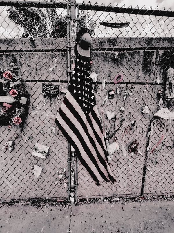
Between May 1995 and April 2000, before the symbolic Memorial grounds opened to the public, tens of thousands come to see for themselves this place of unspeakable loss. The visitors left messages of caring, encouragement and support - often on anything they could find -t-shirts, license plates, key chains, jewelry, cookie boxes and business cards. Many came with flowers, teddy bears and flags. They wrote messages for the family members of those killed, survivors, rescuers and the community-at-large.
The Fence became a destination and an important link connecting those most affected and people from around the country and the world. The Fence brought comfort.
Although not part of the original Memorial design, the Fence was incorporated in its plans and in October 1998- a day after the groundbreaking for the Memorial; family members, survivors and rescue workers joined together and moved sections of the Fence to its current location along Harvey
this page online
Mementos left by visitors are periodically removed and archived for the Memorial collection. These artifacts join countless others gathered from the building, rescue organizations and visitors.
Messages of support are still left even today.
Erected by Oklahoma City National Memorial and Museum.
Topics. This historical marker is listed in this topic list: Disasters. A significant historical date for this entry is April 19, 1995.
Location. 35° 28.405′ N, 97° 31.066′ W. Marker is in Oklahoma City, Oklahoma, in Oklahoma County. It is in the Arts District. It is on North Harvey Avenue north of Northwest 5th Street, on the right when traveling north. The marker is at the far north of the chain link fence along the sidewalk on the west side of the memorial park. Touch for map. Marker is at or near this postal address: 620 North Harvey Ave, Oklahoma City OK 73102, United States of America. Touch for directions.

Regionally, this marker is in Central Oklahoma — Frontier Country. It is also in the American South, specifically on the prairies, and on the Southern Plains. Globally, it is

Photographed by Mark Parker, October 6, 2023
2. The Fence Marker along the chain link fence on the west boundary of the memorial park
Other nearby markers. At least 8 other markers are within walking distance of this marker: Journal Record Building South Wall (within shouting distance of this marker); Children's Area (within shouting distance of this marker); Rescuer Orchard (within shouting distance of this marker); The Field of Empty Chairs (within shouting distance of this marker); Saint Joseph Old Cathedral (within shouting distance of this marker); And Jesus Wept (within shouting distance of this marker); Survivor Tree (about 300 feet away, measured in a direct line); a different marker also named Survivor Tree (about 300 feet away). Touch for a list and map of all markers in Oklahoma City.
Photographed by Mark Parker, October 6, 2023
3. American flag and other mementos left along the fence
Credits. This page was last revised on October 28, 2024. It was originally submitted on September 3, 2024, by Mark Parker of Hickory, North Carolina. This page has been viewed 263 times since then and 44 times this year. Photos: 1, 2, 3. submitted on September 3, 2024, by Mark Parker of Hickory, North Carolina. • J. Makali Bruton was the editor who published this page.
