Enoch in Iron County, Utah — The American Mountains (Southwest)
Samuel Bell Home
| — | Enoch Trails | — |

Photographed by Jeremy Snow, September 3, 2024
1. Samuel Bell Home Marker
Samuel Bell built a house on this site in the 1860s. It burned down in the 1930s and was replaced by the house you see here now. Bell was one of the first permanent settlers at Johnson's Spring and was the first schoolmaster in the old logschool (Marker #2). He developed a spring, which became known as Bell Spring, southeast of the house which provided water for his farm and dairy.
ENOCH TRAILS
Historical Marker #1 GPS: 37.780102 N 113.020852 W Elevation: 5,544 feet
Marker #2 is about 535 feet south on Enoch Road.
Erected by Enoch City - Enoch Trails. (Marker Number 1.)
Topics and series. This historical marker is listed in these topic lists: Education • Settlements & Settlers. In addition, it is included in the Enoch Trails series list. A significant historical year for this entry is 1860.
Location. 37° 46.808′ N, 113° 1.251′ W. Marker is in Enoch, Utah, in Iron County. It is on Enoch Road, on the right when traveling south. Touch for map. Marker is at or near this postal address: 5644 Enoch Road, Cedar City UT 84721, United States of America. Touch for directions.

Regionally, this marker is in Utah’s
this page online
Other nearby markers. At least 8 other markers are within walking distance of this marker: Old Log Schoolhouse (about 500 feet away, measured in a direct line); Johnson's Spring (about 700 feet away); Enoch City Logo (about 800 feet away); Johnson's Fort (approx. 0.2 miles away); Jones Iron Works Park (approx. 0.2 miles away); The Jones Family (approx. 0.3 miles away); Enoch Ward Chapel (approx. half a mile away); Mercantile Building (approx. 0.6 miles away). Touch for a list and map of all markers in Enoch.

Photographed by Jeremy Snow, September 3, 2024
2. Samuel Bell Home Marker
Photographed by Jeremy Snow, September 3, 2024
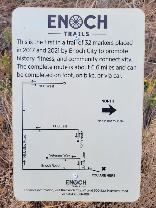
3. Enoch Trails Map

Photographed by Jeremy Snow, September 3, 2024
4. Enoch Trails Sources
Credits. This page was last revised on September 4, 2024. It was originally submitted on September 3, 2024, by Jeremy Snow of Cedar City, Utah. This page has been viewed 156 times since then and 23 times this year. Photos: 1, 2, 3, 4. submitted on September 3, 2024, by Jeremy Snow of Cedar City, Utah. • Andrew Ruppenstein was the editor who published this page.
