Brownfield in Oxford County, Maine — The American Northeast (New England)
Brownfield: The Forest Fires of 1947
Photographed by Conrad Ward, May 23, 2024
1. Brownfield Forest Fires Marker
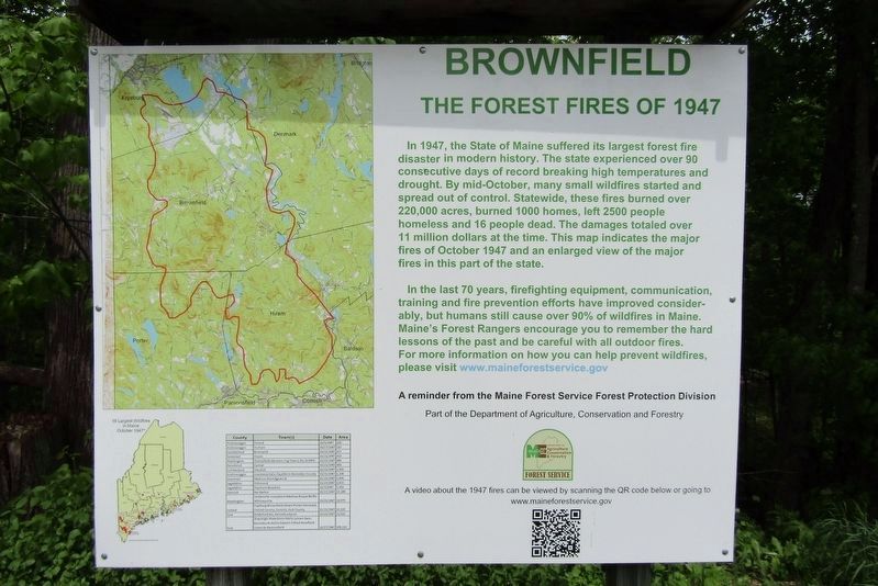
In 1947, the State of Maine suffered its largest forest fire disaster in modern history. The state experienced over 90 consecutive days of record breaking high temperatures and drought. By mid-October, many small wildfires started and spread out of control. Statewide, these fires burned over 220,000 acres, burned 1000 homes, left 2500 people homeless and 16 people dead. The damages totaled over 11 million dollars at the time. This map indicates the major fires of October 1947 and an enlarged view of the major fires in this part of the state.
In the last 70 years, firefighting equipment, communication, training and fire prevention efforts have improved considerably, but humans still cause over 90% of wildfires in Maine. Maine's Forest Rangers encourage you to remember the hard lessons of the past and be careful with all outdoor fires.
For more information on how you can help prevent wildfires, please visit www.maineforestservice.gov
A reminder from the Maine Forest Service Forest Protection Division
Part of the Department of Agriculture, Conservation and Forestry
Erected by Maine Forest Service Forest
this page online
Topics. This historical marker is listed in this topic list: Disasters. A significant historical month for this entry is October 1947.
Location. 43° 56.289′ N, 70° 54.668′ W. Marker is in Brownfield, Maine, in Oxford County. It is on Main Street east of Dugway Road, on the left when traveling east. Located at the Brownfield Historical Society. Touch for map. Marker is at or near this postal address: 258 Main Street, Brownfield ME 04010, United States of America. Touch for directions.

Regionally, this marker is in the Western Maine Lakes and Mountains Region. It is also in the American Northeast and in New England. Globally, it is in North America, the Great North Woods, the Western Hemisphere, the Western World, and the Anglosphere.
Other nearby markers. At least 8 other markers are within 6 miles of this marker, measured as the crow flies: The Colt-Browning M1895 (a few steps from this marker); Brownfield Historical Society (a few steps from this marker); Brownfield Korea & Vietnam Memorial (approx. 0.2 miles away); Daniel A. Bean Monument (approx. 0.2 miles away); Brownfield War Memorial (approx. 0.2 miles away);
Photographed by Conrad Ward, May 23, 2024
2. Brownfield Forest Fires Marker
Also see . . .
1. Maine Forest Service - The 1947 Fires. (Submitted on September 4, 2024, by Conrad Ward of Guilford, Connecticut.)
2. October Fury 1947 Fires - YouTube. On October 23, 1947 thousands of Mainers awoke to a beautiful fall day and none of them could be aware of the impending natural disaster that was about to change their lives forever. (Submitted on September 4, 2024, by Conrad Ward of Guilford, Connecticut.)
3. 1947 Brownfield, Maine Fire - YouTube.
Footage of the Brownfield fire(Submitted on September 4, 2024, by Conrad Ward of Guilford, Connecticut.)
4. Maine Remembers "The Big One".
by Keith A. Smith. January 1998 Wildlife article.(Submitted on September 4, 2024, by Conrad Ward of Guilford, Connecticut.)
Credits. This page was last revised on September 10, 2024. It was originally submitted on September 4, 2024, by Conrad Ward of Guilford, Connecticut. This page has been viewed 655 times since then and 87 times this year. Photos: 1, 2. submitted on September 4, 2024, by Conrad Ward of Guilford, Connecticut. • Michael Herrick was the editor who published this page.
