Downtown in Fairbanks in Fairbanks North Star Borough, Alaska — Northwest (North America)
Corporate Mining
1911 - 1960
| — | Alaska Gold Rush Centennial | — |
Photographed by William Fischer, Jr., August 17, 2024
1. Corporate Mining Marker
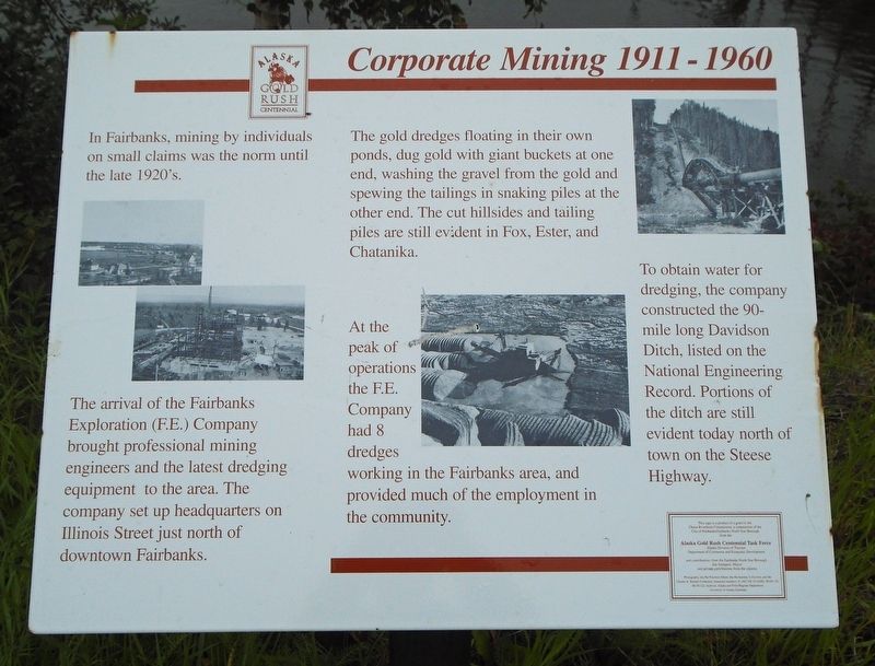
In Fairbanks, mining by individuals on small claims was the norm until the late 1920's.
The arrival of the Fairbanks Exploration (F.E.) Company brought professional mining engineers and the latest dredging equipment to the area. The company set up headquarters on Illinois Street just north of downtown Fairbanks.
The gold dredges floating in their own ponds, dug gold with giant buckets at one end, washing the gravel from the gold and spewing the tailings in snaking piles at the other end. The cut hillsides and tailing piles are still evident in Fox, Ester, and Chatanika.
At the peak of operations the F.E. Company had 8 dredges working in the Fairbanks area, and provided much of the employment in the community.
To obtain water for dredging, the company constructed the 90-mile long Davidson Ditch, listed on the National Engineering Record. Portions of the ditch are still evident today north of town on the Steese Highway.
Erected by Chena Riverfront Commission and Alaska Gold Rush Centennial Task Force.
Topics. This historical marker is listed in this topic list: Industry & Commerce.
Location. 64° 50.64′ N,
this page online

Regionally, this marker is in the Alaska Railroad Corridor, in the Athabascan Region, and in Interior Alaska. It is also on the American Pacific Coast. Globally, it is in North America, on the Pacific Rim, in the Western Hemisphere, in the Western World, and in the Anglosphere. Historically, it finds itself in what was once the Russian Empire.
Other nearby markers. At least 8 other markers are within walking distance of this marker: Fairbanks Area Rotary Projects "Service Above Self" (within shouting distance of this marker); The Early Gold Rush (within shouting distance of this marker); Life Along the Chena River (within shouting distance of this marker); Joe Crosson (about 300 feet away, measured in a direct line); Aviation (about 300 feet away); Fairbanks waterfront, c. 1910
Photographed by William Fischer, Jr., August 17, 2024
2. Corporate Mining Marker
Also see . . . Fairbanks Exploration Company Gold Dredge. (Submitted on September 10, 2024, by William Fischer, Jr. of Reynoldsburg, Ohio.)
Credits. This page was last revised on September 26, 2024. It was originally submitted on September 10, 2024, by William Fischer, Jr. of Reynoldsburg, Ohio. This page has been viewed 171 times since then and 28 times this year. Photos: 1, 2. submitted on September 10, 2024, by William Fischer, Jr. of Reynoldsburg, Ohio.
