Rodanthe in Dare County, North Carolina — The American South (South Atlantic)
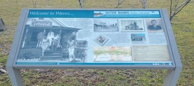
Welcome to Waves…
Outer Banks National Scenic Byway
Photographed by Tom Bosse, September 7, 2024
1. Welcome to Waves… Marker
The village was originally called South Rodanthe. In 1939, with a growing population, the community needed its own post office. The name Waves was suggested by its first postmaster, Anne Midgett. Her home served as the post office. When Mattie Midgett became postmaster, the post office moved to the store owned by Mattie and Ance Midgett. Another village store, Asa H. Gray’s store, drew men of the community every night after summer for discussions.
Waves and Rodanthe share a church established in 1888. Fair Haven Methodist Church (above), named by Israel Brooks Midgett (left), was built on land between the two villages. The original building was located on the southside with two small bridges to its south. Church buildings have been destroyed several times by storms. The current building was dedicated in 1946 and remodeled in 1965. Severely damaged in Hurricane Irene in 2011, the building was raised up, substantially rebuilt and dedicated July 13, 2014.
Waves and Rodanthe share historic building connections. The historic home in front of this panel was built in 1929
this page online
A Taste of Waves
Chicken and Pie Bread
4 lbs chicken ½ tsp salt 3 quarts water ¼ tsp pepper
Catch and kill large hen. Pluck feathers, dress and cut into pieces. Place chicken in a big stew pot of seasoned simmering water. Cook until tender.
Pie Bread
3 cups flour 1 tbsp cooking oil Pinch of salt Approx. 1 ½ cups water
Form the dough into a ball and place on a floured board. Roll into a thin sheet (approx.. 3/8”). Cut into strips, drop into pot. Simmer 15-20 minutes. Add chicken back to pot and serve. Typical Sunday dinner to die for.
Compiled by Jackie Wenberg
(sidebar)
Outer Banks National Scenic Byway
The Outer Banks National Scenic Byway traverses one of the nation’s great coastal landscapes. Tidal marshes, wind-swept dunes, lonesome beaches and beautiful sounds line the
Photographed by Tom Bosse, September 7, 2024
2. Welcome to Waves… Marker
(captions)
North Carolina Governor J. Melville Broughton visits in 1941. Victor Meekins Collection, Outer Banks History Center
Early Fair Haven Methodist Church Church Historic Collection
Current Fair Haven Methodist Church before 1965 remodel J. Wenberg Collection
John F. Wilson I, builder Photo from John F. Wilson IV
Israel Brooks Midgett J. Wenberg Collection
Map by Jim Mitchem
Dedication of Fair Haven United Methodist Church on July 13, 2014 with people from three villages The Coastland Times, Manteo, North Carolina
Erected by Federal Highway Administration National Scenic Byways Program; Dare, Hyde, and Carteret Counties; Dare County Tourism Board.
Topics and series. This historical marker is listed in this topic list: Settlements & Settlers. In addition, it is included in the Outer Banks National Scenic Byway series list. A significant historical year for this entry is 1939.
Location. 35° 34.156′ N, 75° 28.076′ W. Marker is in Rodanthe, North Carolina, in Dare County. It is on North Carolina Route 12 south of La Waves Drive, on the right when traveling south. Touch for map. Marker is in this post office area: Rodanthe NC 27968, United States of America. Touch for directions.

Regionally, this marker is in the Coastal Plain and on the Outer Banks. It is also in the American South, specifically in the Upper South, in the Tidewater, and on the Eastern Seaboard. Globally, it is in the North Atlantic Region, North America, the Western Hemisphere, the Western World, and the Anglosphere. Historically, it finds itself in what was once the territory of the Mississippian Culture, one of the original Thirteen Colonies, one of the Confederate States of America, and the Antebellum South.
Other nearby markers. At least 8 other markers are within 11 miles of this marker, measured as the crow flies: Welcome to Salvo… (approx. 1.7 miles away); "Mirlo" Rescue (approx. 1.8 miles away); The Chicamacomico Races / Exodus from Chicamacomico (approx. 1.8 miles away); Welcome to Rodanthe... (approx. 1.8 miles away); Chicamacomico Life-Saving Station (approx. 1.8 miles away); a different marker also named Mirlo Rescue (approx. 2.3 miles away); A Deep-Rooted Community (approx. 2½ miles away); Charles Kuralt Trail (approx. 10.2 miles away). Touch for a list and map of all markers in Rodanthe.
Another marker is no longer nearby. The Fanny (was approx. 2½ miles away but has been confirmed missing).
Credits. This page was last revised on September 12, 2024. It was originally submitted on September 10, 2024, by Tom Bosse of Jefferson City, Tennessee. This page has been viewed 234 times since then and 43 times this year. Photos: 1, 2. submitted on September 10, 2024, by Tom Bosse of Jefferson City, Tennessee. • Bernard Fisher was the editor who published this page.
