Quadrate in Mannheim, Baden-Württemberg, Germany — Central Europe
Stadt- und Festungsgründung 1606/07
⎯⎯⎯
City and Fortress Foundation in 1606/07
Photographed by James Hulse, September 23, 2024
1. Stadt- und Festungsgründung 1606/07 / City and Fortress Foundation in 1606/07 Marker

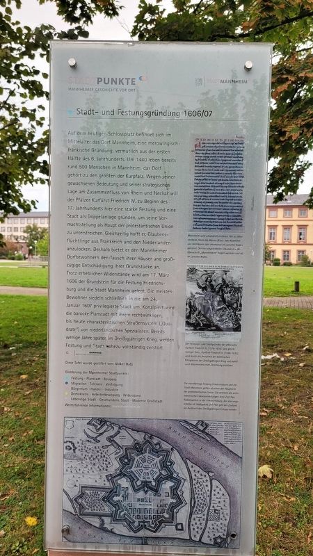
Auf dem heutigen Schlossplatz befindet sich im Mittelalter das Dorf Mannheim, eine merowingischfränkische Gründung, vermutlich aus der ersten Hälfte des 6. Jahrhunderts. Um 1440 leben bereits rund 500 Menschen in Mannheim, das Dorf gehört zu den größten der Kurpfalz. Wegen seiner gewachsenen Bedeutung und seiner strategischen Lage am Zusammenfluss von Rhein und Neckar will der Pfälzer Kurfürst Friedrich IV. zu Beginn des 17. Jahrhunderts hier eine starke Festung und eine Stadt als Doppelanlage gründen, um seine Vormachtstellung als Haupt der protestantischen Union zu unterstreichen. Gleichzeitig hofft er, Glaubensflüchtlinge aus Frankreich und den Niederlanden anzulocken. Deshalb bietet er den Mannheimer Dorfbewohnern den Tausch ihrer Häuser und großzügige Entschädigung ihrer Grundstücke an. Trotz erheblicher Widerstände wird am 17. März 1606 der Grundstein für die Festung Friedrichsburg und die Stadt Mannheim gelegt. Die meisten Bewohner siedeln schließlich in die am 24. Januar 1607 privilegierte Stadt um. Konzipiert wird die barocke Planstadt mit ihrem rechtwinkligen, bis heute charakteristischen Straßensystem (Quadrate") von niederländischen Spezialisten. Bereits wenige Jahre später, im Dreißigjährigen Krieg, werden Festung und Stadt nahezu vollständig zerstört. © Stadtarchiv Mannheim Institut Für Stadtgeschichte
Diese Tafel wurde gestiftet von: Volker Batz
Bildunterschriften
(Foto Nr. 1) Mannheim wird urkundlich erstmals 766 als Mannenheim, Heim des Manno (Kurz- oder Koseform von Hartmann oder Hermann) im Lorscher Kodex genannt. Der hier abgebildeten Urkunde miner Überschrift „Mannenheim" folgen weitere rund 40 im Lorscher Kodex.
(Foto Nr. 2) Der Festungs- und Stadtgründer, der pfälzische Kurfürst Friedrich IV (1574-1610), Sein gleichnamiger Sohn, Kurfürst Friedrich V. (1596-1632), wird durch die Annahme der böhmischen Königskrone den Dreißigjährigen Krieg und damit auch Mannheims erste Zerstörung auslösen.
(Foto Nr. 3) Die sternförmige Festung Friedrichsburg und die Stadt Mannheim gelten als einer der Hauptorte der protestantischen Union. Sie vereinen die architektonischen Idealvorstellungen ihrer Zeit: Das Radialsystem in der Friedrichsburg, das Vierungsschema im Stadtgebiet. Der Plan gibt den Zustand vor Ausbruch des Dreißigillhrigen Krieges wieder.
In
this page online
Photographed by James Hulse, September 23, 2024
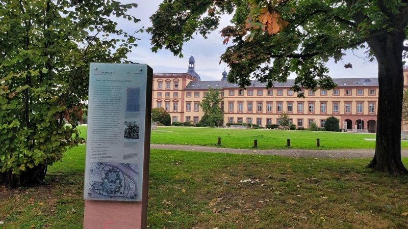
2. The view of the marker with the University of Mannheim in the background
This plaque was donated by: Volker Batz
Captions
(Photo #1) Mannheim was first mentioned in a document in 766 as Mannenheim, home of Manno (short or pet form of Hartmann or Hermann) in the Lorsch Codex. The document shown here with the heading "Mannenheim" is followed by around 40 more in the Lorsch Codex.
(Photo #2) The founder of the fortress and city, the Palatine Elector Frederick IV (1574-1610), his son of the same name, Elector Frederick V (1596-1632), will trigger the Thirty Years' War and thus Mannheim's first destruction by accepting the Bohemian crown.
(Photo #3) The star-shaped fortress of Friedrichsburg and the city of Mannheim are considered one of the main locations of the Protestant Union. They combine the architectural ideals of their time: the radial system in the Friedrichsburg, the crossing scheme in the city area. The plan shows the situation before the outbreak of the Thirty Years' War.
Erected by Stadtpunkte Mannheimer
Photographed by James Hulse, September 23, 2024
3. The view of the marker along the trail on the campus
Topics. This historical marker is listed in this topic list: Forts and Castles. A significant historical date for this entry is January 24, 1607.
Location. 49° 29.018′ N, 8° 27.601′ E. Marker is in Mannheim, Baden-Württemberg. It is in Quadrate. It is on Bismarckstraße just south of A2. The marker is located on the campus of the University of Mannheim in Friedrichs Park. Touch for map. Marker is at or near this postal address: Bismarckstraße 10, Mannheim BW 68159, Germany. Touch for directions.

Regionally, this marker is on the German Upper Rhine. Globally, it is in Europe, the European Union, Atlantic Europe, Central Europe, the Schengen Area, Western Europe, and the Western World. Historically, it finds itself in what was once the Roman Empire, the Holy Roman Empire, and the former West Germany.
Other nearby markers. At least 8 other markers are within walking distance of this marker: Wechselnde Schlossbewohner / Changing Palace Residents (within shouting distance of this marker); Karl Drais und seine Laufmaschine (within shouting distance of this marker); Der Friedrichs-Park 2 / The Friedrichs-Park 2 (within shouting distance of this marker); Der Friedrichs-Park 1 / The Friedrichs-Park 1 (within shouting distance of this marker); Schloss, Sondergericht / Castle, Special Court (about 150 meters away, measured in a direct line); Schlosskirche / Palace Church (about 150 meters away); a different marker also named Schlosskirche / Palace Church (about 150 meters away); Heidelberger Katechismus / Heidelberg Catechism (about 180 meters away). Touch for a list and map of all markers in Mannheim.
Also see . . .
1. Mannheim. Wikipedia
Mannheim is located at the confluence of the Rhine (Upper Rhine) and the Neckar in the Kurpfalz (Electoral Palatinate) region of northwestern Baden-Württemberg. The city lies in the Upper Rhine Plain, Germany's warmest region. Together with Hamburg, Mannheim is the only German city bordering two other federal states.(Submitted on October 2, 2024, by James Hulse of Medina, Texas.)
2. Mannheim Baroque Palace. Stadt Mannheim, Baden-Württemberg and Staatliche Schlösser und Gärten (Submitted on October 3, 2024, by James Hulse of Medina, Texas.)
Credits. This page was last revised on October 3, 2024. It was originally submitted on October 2, 2024, by James Hulse of Medina, Texas. This page has been viewed 158 times since then and 21 times this year. Photos: 1, 2, 3. submitted on October 2, 2024, by James Hulse of Medina, Texas.
