Near Bayfield in Bayfield County, Wisconsin — The American Midwest (Great Lakes)
Boom, Bust, and try to Adjust
Photographed by Connor Olson, October 18, 2024
1. Boom, Bust, and try to Adjust Marker
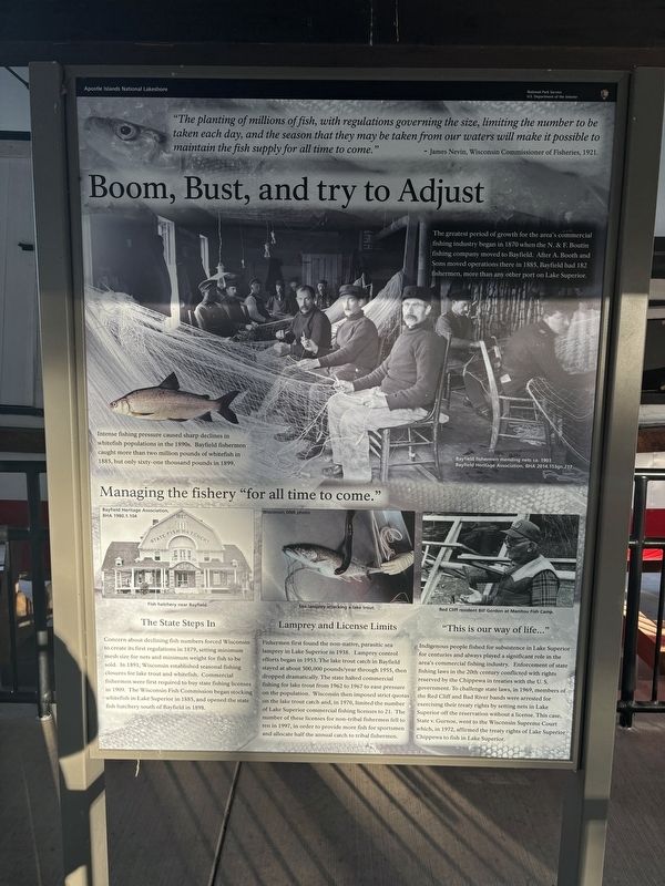
"The planting of millions of fish, with regulations governing the size, limiting the number to be taken each day, and the season that they may be taken from our waters will make it possible to maintain the fish supply for all time to come."
-James Nevin, Wisconsin Commissioner of Fisheries, 1921.
The greatest period of growth for the area's commercial fishing industry began in 1870 when the N. & F. Boutin fishing company moved to Bayfield. After A. Booth and Sons moved operations there in 1885, Bayfield had 182 fishermen, more than any other port on Lake Superior.
Intense fishing pressure caused sharp declines in whitefish populations in the 1890s. Bayfield fishermen caught more than two million pounds of whitefish in 1885, but only sixty-one thousand pounds in 1899.
Managing the fishery "for all time to come."
The State Steps In
Concern about declining fish numbers forced Wisconsin to create its first regulations in 1879, setting minimum mesh size for nets and minimum weight for fish to be sold. In 1891, Wisconsin established seasonal fishing closures for lake trout and whitefish. Commercial fishermen were
this page online
Lamprey and License Limits
Fishermen first found the non-native, parasitic sea lamprey in Lake Superior in 1938. Lamprey control efforts began in 1953. The lake trout catch in Bayfield stayed at about 500,000 pounds/year through 1955, then dropped dramatically. The state halted commercial fishing for lake trout from 1962 to 1967 to ease pressure on the population. Wisconsin then imposed strict quotas on the lake trout catch and, in 1970, limited the number of Lake Superior commercial fishing licenses to 21. The number of these licenses for non-tribal fishermen fell to ten in 1997, in order to provide more fish for sportsmen and allocate half the annual catch to tribal fishermen.
"This is our way of life..."
Indigenous people fished for subsistence in Lake Superior for centuries and always played a significant role in the area's commercial fishing industry. Enforcement of state fishing laws in the 20th century conflicted with rights reserved by the Chippewa in treaties with the U.S. government. To challenge state laws, in 1969, members of the Red Cliff and Bad River bands were arrested for exercising their treaty rights by setting nets in Lake Superior off the reservation without a license. This case, State v. Gurnoe, went to the Wisconsin Supreme Court which, in 1972, affirmed the treaty rights of Lake Superior Chippewa to fish in Lake Superior.
Captions:
Bayfield fishermen mending nets ca. 1903
Fish hatchery near Bayfield.
Sea lamprey attacking a lake trout.
Red Cliff resident Bill Gordon at Manitou Fish Camp.
Erected by National Park Service.
Topics. This historical marker is listed in this topic list: Industry & Commerce. A significant historical year for this entry is 1870.
Location. 46° 56.768′ N, 90° 53.399′ W. Marker is near Bayfield, Wisconsin, in Bayfield County. It is on Little Sand Bay Road. Touch for map. Marker is at or near this postal address: 32660 Little Sand Bay Rd, Bayfield WI 54814, United States of America. Touch for directions.

Regionally, this marker is on the North Shore. It is also in the American Midwest, in the Corn Belt, and on Lake Superior’s South Shore Region. Globally, it is in North America, in the Great North Woods, on the Great Lakes, in the Western Hemisphere, in the Western World, and in the Anglosphere. Historically, it finds itself in what was once the territory of the Mississippian Culture and also the Northwest Territory.
Other nearby markers. At least 8 other markers are within 10 miles of this marker, measured as the crow flies: …the Forest for the Trees (here, next to this marker); Living on the Edge (here, next to this marker); A Family Affair (a few steps from this marker); Hokenson Brothers Fishery (within shouting distance of this marker); The Twilight Fishermen (within shouting distance of this marker); Steamer Sevona (within shouting distance of this marker); Cultural Fire Returns to Stockton Island (approx. 9.8 miles away); Bayfield Historic Waterfront (approx. 9.9 miles away). Touch for a list and map of all markers in Bayfield.
Credits. This page was last revised on October 21, 2024. It was originally submitted on October 19, 2024, by Connor Olson of Menomonee Falls, Wisconsin. This page has been viewed 135 times since then and 27 times this year. Photo 1. submitted on October 19, 2024, by Connor Olson of Menomonee Falls, Wisconsin. • J. Makali Bruton was the editor who published this page.
