Thomaston in Knox County, Maine — The American Northeast (New England)
Two Historic Churches and Good Neighbors
Thomaston, Maine
| — | The Museum in the Streets | — |

Photographed by Darren Jefferson Clay, October 15, 2024
1. Two Historic Churches and Good Neighbors Marker
Two Historic Churches and Good Neighbors
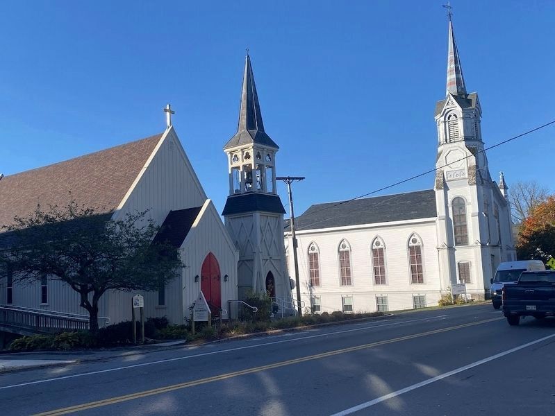
The Thomaston Baptist Church to the right was chartered in 1816. The Episcopal Church, St. John Baptist, has been its neighbor for its entire life. The two set the tone for the degree of cooperation between all of the various denominations in town. When the Baptist church's steeple burned in the 1990s, collections were taken up in all of the religious institutions in the area to help rebuild the steeple and repair the damage done by smoke and water.
The tall steeple of the Baptist Church can be seen a good distance from our shore. Ships sailing up the St. Georges River in the nineteenth century used the steeple to set their course for smooth sailing into Thomaston.
Deux Églises Historiques
L'église baptiste de Thomaston, à droite, fondée en 1816, et celle de gauche, l'Eglise épiscopale St. Jean-Baptiste, cohabitent depuis l'édification de cette dernière. Ce bon voisinage est un symbole de l'entente cordiale qui caractérise les relations entre les différents cultes à Thomaston. Lorsque le clocher de l'église baptiste a été détruit en 1990, ce sont les autres églises de la région
this page online
On peut distinguer le grand clocher de l'église baptiste d'assez loin, au large des côtes. Ainsi, au 19ème siècle, les navires sur l'estuaire du fleuve St. Georges s'orientaient à l'aide de ce clocher afin d'atteindre Thomaston dans les meilleures conditions.
Erected by The Museum in the Streets. (Marker Number 9.)
Topics. This historical marker is listed in this topic list: Religion & Religious Structures.
Location. 44° 4.716′ N, 69° 11.031′ W. Marker is in Thomaston, Maine, in Knox County. It is on Main Street (U.S. 1) near Green Street, on the right when traveling east. Touch for map. Marker is at or near this postal address: 200 Main Street, Thomaston ME 04861, United States of America. Touch for directions.

Regionally, this marker is in Midcoast Maine and on Penobscot Bay. It is also in the American Northeast, in New England, and on the Eastern Seaboard. Globally, it is in the North Atlantic Region, North America, the Western Hemisphere, the Western World, and the Anglosphere.
Other nearby markers. At
Photographed by Darren Jefferson Clay, October 15, 2024
2. Two Historic Churches and Good Neighbors
The Episcopal Church of St. John Baptist is on the left, the Thomaston Baptist Church on the right.
Also see . . .
1. Episcopal Church of St. John Baptist. (Submitted on November 1, 2024, by Michael Herrick of Southbury, Connecticut.)
2. Thomaston Baptist Church. (Submitted on November 1, 2024, by Michael Herrick of Southbury, Connecticut.)

Photographed by Darren Jefferson Clay, October 15, 2024
3. The Episcopal Church of St. John the Baptist

Photographed by Darren Jefferson Clay, October 15, 2024
4. The Thomaston Baptist Church
Credits. This page was last revised on November 1, 2024. It was originally submitted on October 26, 2024, by Darren Jefferson Clay of Duluth, Georgia. This page has been viewed 160 times since then and 23 times this year. Photos: 1, 2, 3, 4. submitted on October 26, 2024, by Darren Jefferson Clay of Duluth, Georgia. • Michael Herrick was the editor who published this page.
