New Britain in Capitol Region, Connecticut — The American Northeast (New England)
Arch Street Architecture
⎯⎯⎯
In the Heart of the City For the Heart of the City
| — | New Britain Historic Walking Trail | — |

Photographed by Duane and Tracy Marsteller, September 29, 2024
1. Arch Street Architecture side of marker
Arch Street Architecture
The buildings of Arch Street date back to the turn of the twentieth century and offer an intertwined look at both the past and the present. Arch Street offers multiple examples of the Italianate and Beaux Arts architectural styles, which were popular in the late nineteenth to early twentieth centuries. The Italianate style can be seen at 180 Arch Street and is characterized by low-sloped or flat roofs, projecting cornices supported by elaborate brackets, and arched windows. The Beaux Arts style can be seen at 191 Arch Street and exhibits elaborate stone detailing, including columns, pediments, and moldings.
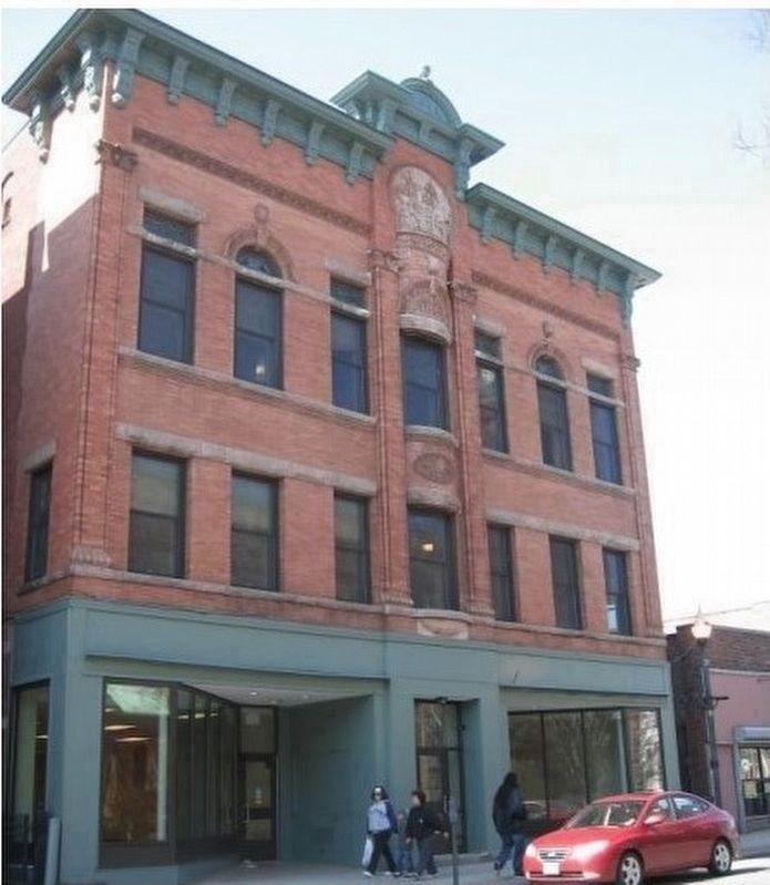
Arch Street displays the work of New Britain's most prominent architect, William H. Cadwell (1863-1941). In his lifetime Cadwell established himself as not only New Britain's leading architect, but also one of the best-known of central Connecticut. His work can be seen at 59 Arch Street (formerly the Vega Society Benefit Hall), and 191 Arch Street. The flamboyant Vega building, built in 1897, exhibits yellow brick, terracotta accents, stained glass windows, and intricate molding. Both buildings
this page online
William Cadwell's own Châteauesque home, which he designed and built in 1891 as a wedding gift for his bride, Frances Hadley, is just around the corner at 130 West Main Street.
The New Britain Armory stands at the corner of Arch and Grand Streets. Prominent Waterbury architect Robert Wakeman Hill designed the imposing structure in 1886. After the state abandoned the building, the Hartford Architecture Conservancy renovated the facility to be used as housing in 1992. The large dome that once topped the central tower has never been replaced.
In the late 1990s ornamental paving, lighting, trees, and other streetscape elements were added along Arch Street following a plan by New Britain landscape architects TO Design LLC.
At the turn of the twenty-first century the Friendship Service Center added a new building to the streetscape. Designed by New Britain architects Kaestle Boos Associates, the building reflects the collective style of its time.
[Captions top to bottom)]
• Arch Street looking north – unknown date
• The Vega Building's (1897) elaborate ornamentation includes a bas-relief panel depicting a steamship perhaps bringing Swedish immigrants to New Britain.
• 67-69 Arch Street exhibits a variety of delightful accentuation including patterned brick work, ornate low dentils, brick pilasters and fenestrated window lintels.
• The New Britain Armory tower last had its original domed roof in the late 20th century. The structure was renovated to affordable housing.
In the Heart of the City
For the Heart of the City
A

Photographed by Duane and Tracy Marsteller, September 29, 2024
2. In the Heart of the City For the Heart of the City side of Markerm
New Britain has served as a social services hub for the region for over a century, with many of the services located on Arch Street. In addition to the cultural societies, the City Mission and Town Farm, on Rocky Hill Avenue, once provided supportive services for the city's poor. Since the 1890s, the Salvation Army has been a part of New Britain's social services when it began providing food services to the local population,

Photographed by Duane and Tracy Marsteller, September 29, 2024
3. Arch Street Architecture / In the Heart of the City For the Heart of the City Marker
The Friendship Service Center, originally founded in 1968 by Monsignor Joseph Farrell, came to 241 Arch Street in 1992. The center provides many services including counseling, meals, family shelter, and supportive housing. Currently, the center operates out of three locations on the street, including the Vega Building.
Citizens have advocated for Arch Street since at least the 1880s, and efforts from the last half of the twentieth century illustrate continual concern. In the 1990s, the city created the Arch Walkway, which linked Arch Street with the downtown area and included historic streetlights, benches, trees, and markers identifying points of interest. In recent years, a Latino neighborhood has emerged along Arch Street, continuing the street's long tradition as a place of ethnic cultural continuity and community.
[Captions (top to bottom)]
• The Friendship Service Center has been on Arch Street since 1989.
• (Above) Youth gather for an Austrian Society party at the Dutton Club on Arch Street in 1938. (Local History, NBPL)
• (Right) New Britain Parks and Recreation staff deliver groceries donated by summer campers to the Friendship Service Center.
Erected by City
Unknown; from New Britain, Connecticut Historic Preservation Action Plan (2010) (Public Domain)
4. Former Vega Society Benefit Hall
The building has Italianate features such as arched windows, a square central tower, and eave brackets.
Topics. This historical marker is listed in these topic lists: Architecture • Charity & Public Work • Fraternal or Sororal Organizations. A significant historical year for this entry is 1897.
Location. 41° 39.863′ N, 72° 46.941′ W. Marker is in New Britain in Capitol Region, Connecticut. It is on Arch Street 0.1 miles south of Walnut Street, on the right when traveling south. Touch for map. Marker is at or near this postal address: 105 Arch St, New Britain CT 06051, United States of America. Touch for directions.

Regionally, this marker is in the Connecticut River Valley, in Greater Hartford, and in the Knowledge Corridor. It is also in the American Northeast and in New England. Globally, it is in North America, the Western Hemisphere, the Western World, and the Anglosphere. Historically, it finds itself in what was once Hartford County and also one of the original Thirteen Colonies.
Other nearby markers. At least 8 other markers are within walking distance of this marker: Central Park / Early Industries (approx. 0.2 miles away); New Britain Veterans Memorial (approx. 0.2

Unknown; from New Britain, Connecticut Historic Preservation Action Plan (2010) (Public Domain)
5. The Former Armory
The Armory at 232 Arch Street with its massive proportions, masonry construction, rounded-arch entryway and upper motif, and towers with conical roofs, evidences the Victorian Romanesque style.
Credits. This page was last revised on May 19, 2026. It was originally submitted on November 1, 2024, by Duane and Tracy Marsteller of Murfreesboro, Tennessee. This page has been viewed 441 times since then and 98 times this year. Photos: 1, 2. submitted on November 1, 2024, by Duane and Tracy Marsteller of Murfreesboro, Tennessee. 3, 4, 5. submitted on November 2, 2024, by Duane and Tracy Marsteller of Murfreesboro, Tennessee.
Editor’s want-list for this marker. Clear closeup photograph of Arch Street Architecture side of marker • Can you help?
