
Bar Harbor in Hancock County, Maine — The American Northeast (New England)
La Rochelle
Bar Harbor, Maine
| — | The Museum in the Streets | — |

Photographed by Darren Jefferson Clay, October 16, 2024
1. La Rochelle Marker
Constructed in 1903 by Mr. George Sullivan Bowdoin, a partner in J.P. Morgan Co., this Georgian Revival style mansion was called "La Rochelle," French for "the Little Rocks." The design boasted 35 rooms, 15 bathrooms, 11 fireplaces and accommodations for 20 servants. The stately manor later became the summer home of Dr. John Dorrance, a chemist, who invented condensed soup and later became the president of Campbell Soup Company. In 1972 his grandson, Tristram C. Colket, donated the estate to the Maine Seacoast Mission and it remained their headquarters until 2018. La Rochelle is now the home of the Bar Harbor Historical Society where tours are offered.
Ce manior de style Néo-Géorgien est construit en 1903 par M. George Sullivan Bowdoin, partenaire de la banque J.P. Morgan. Il porte le nom de « La Rochelle », du français < petits rochers ». La conception prévoit 35 chambres, 15 salles de bain, 11 cheminées et un hébergement pour 20 domestiques. Cet im- posant manoir devient la résidence d'été du Dr. John Dorrance, chimiste de profession et inventeur de la soupe condensée. Il deviendra P.D.G. de la Société Campbell Soup. En 1972, son petit-fils Tristam C. Colket fait donation de la propriété à la Maine Seacoast Mission qui y établit son siège jusqu'en 2018. La Rochelle héberge aujourd'hui La Société Historique de Bar Harbor qui propose des visites guidées.
Erected by The Museum in the Streets. (Marker Number 5.)
Topics and series. This historical marker is listed in this topic list: Notable Buildings. In addition, it is included in the The Museum in the Streets: Bar Harbor, Maine series list.
Location. 44° 23.394′ N,
this page online

Regionally, this marker is on Mount Desert Island and in Downeast Maine. It is also in the American Northeast, in New England, and on the Eastern Seaboard. Globally, it is in the North Atlantic Region, North America, the Great North Woods, the Western Hemisphere, the Western World, and the Anglosphere. Historically, it finds itself in what was once the Viceroyalty of New France and also Acadia.
Other nearby markers. At least 8 other markers are within walking distance of this marker: The Great Fire / Le Grand Incendie (about 600 feet away, measured in a direct line); Bar Harbor Municipal Building (about 700 feet away); DeGregoire Green (about 700 feet away); The Cottage Era (approx. 0.2 miles away); The Kedge (approx. 0.2 miles away); Bar Island (approx. 0.2 miles away); Bar Island Path (approx. 0.2 miles away); In Memory of Those Who Made the Supreme Sacrifice

Photographed by Darren Jefferson Clay, October 16, 2024
2. La Rochelle Marker
Also see . . . Bar Harbor Historical Society. (Submitted on November 9, 2024, by Michael Herrick of Southbury, Connecticut.)
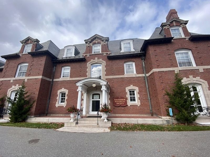
Photographed by Darren Jefferson Clay, October 16, 2024
3. La Rochelle
Credits. This page was last revised on November 9, 2024. It was originally submitted on November 3, 2024, by Darren Jefferson Clay of Duluth, Georgia. This page has been viewed 231 times since then and 29 times this year. Photos: 1, 2. submitted on November 3, 2024, by Darren Jefferson Clay of Duluth, Georgia. 3. submitted on November 4, 2024, by Darren Jefferson Clay of Duluth, Georgia. • Michael Herrick was the editor who published this page.
