Prospect in Waldo County, Maine — The American Northeast (New England)
A Question of Boundaries
Photographed by William Fischer, Jr., September 23, 2011
1. A Question of Boundaries Marker
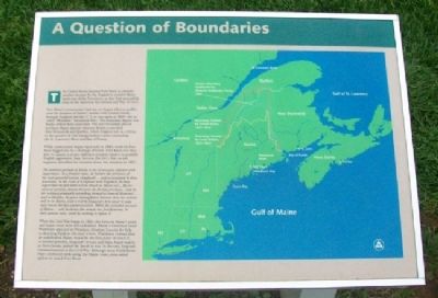
The United States planned Fort Knox to prevent another attempt by the English to control Maine lands east of the Penobscot, as they had successfully done in the American Revolution and War of 1812.
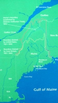
Fort Knox's construction had not yet begun when a conflict over the location of Maine's border with Canada briefly brought England and the U.S. to war again in 1839 (the so-called "Bloodless" Aroostook War). The boundary dispute was finally settled three years later. The new boundary placed northern Maine directly between British-controlled New Brunswick and Québec, which England saw as a threat to the security of vital transportation routes connecting the St. Lawrence River and Bay of Fundy.
While construction began vigorously in 1845, work on Fort Knox lagged due to a shortage of funds. Fort Knox was thus slow to assume a proper defensive position relative to possible English aggression. Isaac Stevens, the fort's first on-site engineer, described his concerns about the situation in 1851:
The military position of Maine is one of unusual exposure and importance. As a frontier state, she borders the provinces of the most powerful nation (England)...and is enveloped by these possessions. In the event of a rupture with England, we may expect that the first blow will be struck on Maine soil...By her natural position, thrown between the British provinces...and by her railways gradually extending themselves toward Montreal...and to Halifax, the great thoroughfares between these two sections will be in Maine, and it will be England's first object to seize and retain this key communication. While the extended seacoast of Maine...will facilitate this attack, her fortifications, in their present state, could do nothing to oppose it.
When
this page online
Erected by Maine Department of Conservation.
Topics. This historical marker is listed in these topic lists: Forts and Castles • Peace • Political Subdivisions. A significant historical year for this entry is 1812.
Location. 44° 33.987′ N, 68° 48.124′ W. Marker is in Prospect, Maine, in Waldo County. It can be reached from Fort Knox Road (Maine Route 174). Marker is at the entrance to the fort, at Fort Knox State Historic Site. Touch for map. Marker is at or near this postal address: 740 Ft Knox Rd, Stockton Springs ME 04981, United States of America. Touch for directions.

Regionally,
Photographed by Maine Dept of Conservation, undated
2. Image on A Question of Boundaries Marker
Other nearby markers. At least 8 other markers are within walking distance of this marker: A Grand Plan (here, next to this marker); The Architecture of Defense (here, next to this marker); Fort Knox (a few steps from this marker); Digging Down and Building Up (within shouting distance of this marker); The Heart of the Fort (within shouting distance of this marker); Where Did the Soldiers Sleep? (within shouting distance of this marker); The Casemate - Key to Fort Design (within shouting distance of this marker); Firing a Cannon (within shouting distance of this marker). Touch for a list and map of all markers in Prospect.
Also see . . .
1. Fort Knox State Historic Site, Maine. Legends of America website entry (Submitted on May 7, 2012, by William Fischer, Jr. of Reynoldsburg, Ohio.)
2. The Border Dispute and the "Aroostook War". (Submitted on May 7, 2012, by William Fischer, Jr. of Reynoldsburg, Ohio.)
Photographed by William Fischer, Jr., September 23, 2011
3. A Question of Boundaries Marker
Credits. This page was last revised on July 13, 2025. It was originally submitted on May 7, 2012, by William Fischer, Jr. of Reynoldsburg, Ohio. This page has been viewed 778 times since then and 19 times this year. Last updated on November 3, 2024, by Darren Jefferson Clay of Duluth, Georgia. Photos: 1, 2, 3. submitted on May 7, 2012, by William Fischer, Jr. of Reynoldsburg, Ohio. • Devry Becker Jones was the editor who published this page.
