Westmont in Haddon Township in Camden County, New Jersey — The American Northeast (Mid-Atlantic)
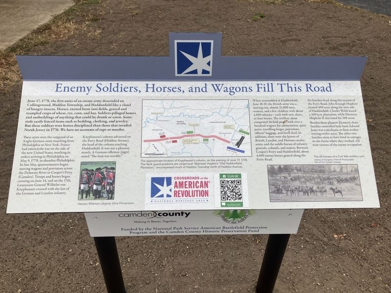
Enemy Soldiers, Horses,and Wagons Fill this Road
Photographed by Thomas Anderson, November 1, 2024
1. Enemy Soldiers, Horses,and Wagons Fill this Road Marker
June 17, 1778, the first units of an enemy army descended on Collingswood, Haddon Township, and Haddonfield like a cloud of hungry insects. Horses, turned loose on fields, grazed and trampled crops of wheat, rye, corn, and hay. Soldiers pillaged homes and outbuildings of anything that could be drunk, or eaten. Some stole easily fenced items such as bedding, clothing, and jewelry. But these solders were better disciplined than those that invaded North Jersey in 1776. We have no accounts of rape or murder.
These units were the vanguard of an Anglo-German army from Philadelphia to New York. France had entered the war on the side of the new United States, resulting in orders arriving in May 9, 1788, to abandon Philadelphia. In late May, quartermasters began moving wagons and provisions across the Delaware River to Cooper's Ferry (Camden). Troops and horses began crossing on June 14, and on the 17th, Lieutenant General Wilhelm von Knyphausen crossed with the last of the German and Loyalist Infantry.
Knyphausen’s column advanced on the Ferry Road (Haddon Avenue), the head of the column reaching Haddonfield. A German rifleman
this page online
When reassembled at Haddonfield, June 18-19, the British army was a moving city, almost 21,000 men, women, and a few children with about 1,000 vehicles—each with two, three or four horses. The artillery alone comprised 46 field pieces with over a hundred wagons for ammunition, spare parts, traveling forges provisions, officers' baggage, and horse feed. In addition, there were the horses of British, Loyalist, and Hessian cavalry units, and the saddle horses of infantry generals, colonels, and majors. Between Cooper's Ferry and Haddonfield, about 4,000 enemy horses grazed along the Ferry Road.
Six families lived along this section of the Ferry Road. John Estaugh Hopkins farmed 400 acres along the west side of Haddonfield. Charles Webb leased a 100 acre plantation, while Ebenezer Hopkins II was taxed for 368 acres.
Besides these planters (farmers), three families controlled little land. Edward Jones was a mechanic or farm worker renting twelve acres. The other two families seem to have lived in cottages on the farms where they worked. All were victims of the enemy occupation.
( photo captions )
—

Photographed by Thomas Anderson, November 7, 2024
2. Revolutionary road.
— (map) The approximate location of Knyphausen’s column, on the eveningof June 17, 1778. The flank guard positions are conjectural. Ebenezer Hopkin’s “Old Haddonfield Plantation,” encompassed much of Haddon Township north of Haddon Avenue.
— The 60 horses of a Civil War artillery unit. Library of Congress, Prints & Photographs Gift of Col. Godwin Ordway
Topics. This historical marker is listed in this topic list: War, US Revolutionary.
Location. 39° 54.629′ N, 75° 2.955′ W. Marker is in Haddon Township, New Jersey, in Camden County. It is in Westmont. It is at the intersection of Haddon Avenue and Wynnewood Avenue, on the right when traveling west on Haddon Avenue. Located next to the Haddon Township Municipal building. Touch for map. Marker is at or near this postal address: 135 Haddon Avenue, Collingswood NJ 08108, United States of America. Touch for directions.

Regionally, this marker is in South Jersey and in Greater Philadelphia. It is also in the American Northeast, in the Mid-Atlantic, and on the Eastern Seaboard. Globally, it is in the North Atlantic Region, North America, the Western Hemisphere, the Western World, and the Anglosphere. Historically, it finds itself in what was once New Netherland and also one of the original Thirteen Colonies.
Other nearby markers. At least 8 other markers are within 2 miles of this marker, measured as the crow flies: Saddlertown (approx. 0.6 miles away); Saddler’s Woods (approx. 0.8 miles away); Pennypacker Trail (approx. 0.9 miles away); Hadrosaurus Foulkii (approx. 1.1 miles away); Haddonfield - A Quaker Village Engulfed by War (approx. 1.1 miles away); Old Grove School (approx. 1.1 miles away); Quaker Graveyard (approx. 1.1 miles away); Artillery Park (approx. 1.2 miles away). Touch for a list and map of all markers in Haddon Township.
Credits. This page was last revised on November 13, 2024. It was originally submitted on November 7, 2024, by Thomas Anderson of Haddon Township, New Jersey. This page has been viewed 219 times since then and 27 times this year. Photos: 1, 2. submitted on November 7, 2024, by Thomas Anderson of Haddon Township, New Jersey. • Michael Herrick was the editor who published this page.
