Excelsior in Hennepin County, Minnesota — The American Midwest (Upper Plains)
The Excelsior Amusement Park
| — | Excelsior | — |
Photographed by McGhiever, April 14, 2023
1. The Excelsior Amusement Park Marker
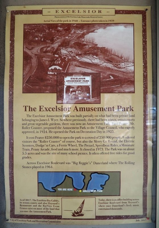
The Excelsior Amusement Park was built partially on what had been private land belonging to James I. Wyer. So where previously, there had been a lawn, tennis courts and great vegetable gardens, there was now an Amusement Park. Fred Pearce, Mr. Roller Coaster, proposed the Amusement Park to the Village Council, who eagerly approved, in 1924. He opened the Park on Decoration Day in 1925.
It cost Pearce $250,000 to open the park to a crowd of 250,000 people. It offered visitors the "Roller Coaster" of course, but also the Merry Go Round, the Electric Scooters, Dodge'm Cars, a Ferris Wheel, The Pretzel, Speedboat Rides, a Miniature Train, Penny Arcade, food and much more. It closed in 1973. The Park was on about 5.5 acres and was the site of many school picnics. It often offered free rides for good grades.
Across Excelsior Boulevard was "Big Reggie's" Danceland where The Rolling Stones played in 1964.
As of 2017, The Excelsior Bay Gables, its tennis courts and also Maynard's Restaurant and the BayView Event Center exist on most of the land that was once the Amusement Park.
Today, there is an office building across Excelsior Boulevard from Maynard's where once Danceland's lively music entertained thousands.
Erected 2017
this page online
Topics. This historical marker is listed in these topic lists: Entertainment • Industry & Commerce. A significant historical year for this entry is 1925.
Location. 44° 54.275′ N, 93° 33.908′ W. Marker is in Excelsior, Minnesota, in Hennepin County. It can be reached from the intersection of Water Street and Lake Street. The marker is inside the kiosk at the Port of Excelsior. Touch for map. Marker is at or near this postal address: 2 Water Street, Excelsior MN 55331, United States of America. Touch for directions.

Regionally, this marker is in the Twin Cities Metropolitan Area. It is also in the American Midwest, in the Corn Belt, and in the Great River Road Region. Globally, it is in North America, the Western Hemisphere, the Western World, and the Anglosphere. Historically, it finds itself in what was once Rupert’s Land, the territory of the Mississippian Culture, and the Louisiana Purchase.
Other nearby markers. At least 8 other markers are within walking distance of this marker: Excelsior - Who We Are (here, next to this marker); The Legacy of Excelsior (here,

Photographed by McGhiever, April 14, 2023
2. The Excelsior Amusement Park Marker (second from left) inside the kiosk at the Port of Excelsior
Credits. This page was last revised on November 7, 2024. It was originally submitted on November 7, 2024, by McGhiever of Minneapolis, Minnesota. This page has been viewed 453 times since then and 103 times this year. Photos: 1. submitted on November 7, 2024, by McGhiever of Minneapolis, Minnesota. 2. submitted on November 5, 2024, by McGhiever of Minneapolis, Minnesota.
