
Altstadt in Heidelberg, Baden-Württemberg, Germany — Central Europe
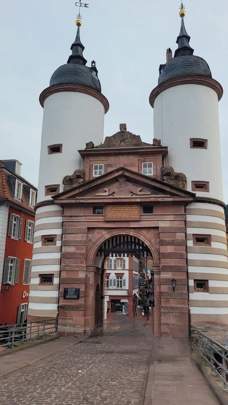
Alte Brücke
⎯⎯⎯
Old Bridge

Photographed by James Hulse, September 22, 2024
1. Alte Brücke / Old Bridge Marker

1284, 21. Mai - Erste erwähnung einer Neckarbrücke in Heidelberg
13.-18. Jahrhundert - Holzbrücken auf steinpfeilern mehrfach durch hochwasser und krieg zerstört
1784, 27. Februar - Eisgang mit extremer pegelhöhe
1786-1788 - Wiederaufbau als stein brücke durch Matthias Mayer (+1791) Die plastiken -athene und kurfürst Karl Theodor umgeben von flussgottheiten- von Franz Konrad Linck (1730-1793)
1945, 29. März - Sprengung zweier pfeiler durch die wehrmacht
1946, 14. Mai - Beginn des wiederaufbaus durch Rudolf Steinbach (1903-1966)
1947, 26. Juni - Einweihung der wieder hergestellten brücke
1284, May 21 - First mention of a bridge over the Neckar River in Heidelberg.
13th–18th centuries - Wooden bridges on stone pillars, repeatedly destroyed by floods and wars.
1784, February 27 - Ice floe with extreme water level.
1786-1788 - Reconstruction as a stone bridge by Matthias Mayer (+1791). The sculptures of Athena and Elector Karl Theodor surrounded by river deities were created by Franz Konrad Linck (1730-1793).
1945, March 29 - Detonation of two
this page online
1946, May 14 - Beginning of the reconstruction by Rudolf Steinbach (1903-1966).
1947, June 26 - Inauguration of the reconstructed bridge.
Erected 2010.
Topics. This historical marker is listed in this topic list: Notable Buildings. A significant historical date for this entry is February 27, 1284.
Location. 49° 24.802′ N, 8° 42.577′ E. Marker is in Heidelberg, Baden-Württemberg. It is in Altstadt. It is at the intersection of Neckarstaden and Steingasse on Neckarstaden. The marker is located on the north side of the gate tower for the bridge. Touch for map. Marker is at or near this postal address: Neckarstaden 66, Heidelberg BW 69117, Germany. Touch for directions.

Regionally, it is in Europe, the European Union, Atlantic Europe, Central Europe, the Schengen Area, Western Europe, and the Western World. Historically, it finds itself in what was once the Roman Empire and specifically also the Holy Roman Empire.
Other nearby markers. At least 8 other markers are within walking distance of this marker: A different marker also named Alte Brücke / Old Bridge (a few steps from this marker); Die Steinbrücke von 1788 / The Stone Bridge of 1788
Photographed by James Hulse, September 22, 2024
2. The marker is located on the left side of the gate tower

Photographed by James Hulse, September 22, 2024
3. The view of the Old Bridge from the street

Photographed by James Hulse, September 22, 2024
4. The view of the Heidelberg Castle from the bridge
Credits. This page was last revised on February 18, 2026. It was originally submitted on November 20, 2024, by James Hulse of Medina, Texas. This page has been viewed 303 times since then and 86 times this year. Photos: 1, 2, 3, 4. submitted on November 21, 2024, by James Hulse of Medina, Texas.
