Port Perry in Durham Region, Ontario — Central Canada (North America)
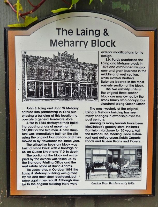
The Laing & Meharry Block
Photographed by Cosmos Mariner, June 2, 2024
1. The Laing & Meharry Block Marker
John B. Laing and John W. Meharry entered into partnership in 1874 purchasing a building at this location to operate a general hardware store.
A fire in 1884 destroyed their building causing a loss of more than $16,000 for the two men. A new structure was immediately built on the site using the original foundations and they moved in by November the same year.
The attractive two-story block was built of white brick, with a frontage of 66' on Queen Street and 110' in depth.
The portion of the block not occupied by the owners was taken up by the Standard Printing Office and the real estate office of David Adams.
Six years later, in October 1891 the Laing & Meharry building was gutted by fire and their stock destroyed, but once again they rebuilt. Although similar to the original building there were exterior modifications to the design.
E.H. Purdy purchased the Laing and Meharry block in 1897 and established his grocery and grain business in the middle and west section, while Cawker Brothers Butchers located in the most easterly section of the block.
The two easterly units of the original three section block are now owned by
this page online
The most westerly of the original Laing & Meharry building has seen many changes in ownership over the past century.
Among its many tenants have been McClintock's grocery store, Pickard's Dominion Hardware for 20 years, Karl the Butcher, The Meeting Place restaurant and delicatessen, Reid's Organic Foods and Queen Beans and Plover's.
Topics. This historical marker is listed in these topic lists: Architecture • Disasters • Industry & Commerce. A significant historical month for this entry is October 1891.
Location. 44° 6.302′ N, 78° 56.591′ W. Marker is in Port Perry, Ontario, in Durham Region. It is on Queen Street just west of Water Street, on the left when traveling west. The marker is mounted at eye-level near the center of the north/front facade of the subject building. Touch for map. Marker is at or near this postal address: 176 Queen Street, Port Perry ON L9L 1B8, Canada. Touch for directions.

Regionally, this marker is in Greater Toronto, specifically on the Golden Horseshoe, in the York, Durham and Headwaters Area, and in the Toronto Metropolitan Area.

2. Marker detail: Cawker Bros. Butchers early 1900s
Other nearby markers. At least 8 other markers are within walking distance of this marker: Aaron Ross & William Brock Block (here, next to this marker); The Allison Block (within shouting distance of this marker); Canadian Bank of Commerce (within shouting distance of this marker); The Blong Block (within shouting distance of this marker); The Ackerman Block (within shouting distance of this marker); Port Perry Post Office (within shouting distance of this marker); The McCaw Block (within shouting distance of this marker); Aaron Ross Block (within shouting distance of this marker). Touch for a list and map of all markers in Port Perry.
Also see . . . Fire Returns to Port Perry in 1891.
(By Paul Arculus) Excerpt: Once again, on Oct. 22, 1891, residents of the town were awakened in the middle of(Submitted on November 23, 2024, by Cosmos Mariner of Cape Canaveral, Florida.)the night by the dreadful clatter of the fire bell when a huge blaze was discovered underway in the heart of downtown. The flames had already made themselves visible through the roof at the rear of the Laing & Meharry hardware store. All the buildings were new brick structures, which had fortunately been built with fire walls, and the fire was brought under control by 4 a.m. due to the extraordinary efforts of the local fire company and its excellent fire engine, which poured tons of water onto the blaze. Laing & Meharry's establishment was completely gutted and their stock completely destroyed.Photographed by Cosmos Mariner, June 2, 20243. The Laing & Meharry Block MarkerThe marker is mounted on the left side of the center unit entrance.


Photographed by Cosmos Mariner, June 2, 2024
4. The Laing & Meharry Block (north/front elevation)
The block comprises 3 units, the western (rightmost) of which is partially cut off in this photo.
Credits. This page was last revised on November 23, 2024. It was originally submitted on November 22, 2024, by Cosmos Mariner of Cape Canaveral, Florida. This page has been viewed 129 times since then and 19 times this year. Photos: 1, 2, 3, 4. submitted on November 23, 2024, by Cosmos Mariner of Cape Canaveral, Florida.
