Enosburg in Franklin County, Vermont — The American Northeast (New England)
West Enosburg United Methodist Church
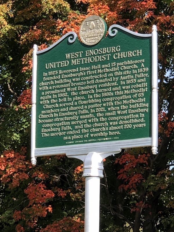
Photographed by Duane and Tracy Marsteller, October 4, 2024
1. West Enosburg United Methodist Church Marker
Erected 2024 by Vermont Division for Historic Preservation.
Topics and series. This historical marker is listed in this topic list: Religion & Religious Structures. In addition, it is included in the Vermont Division for Historic Preservation Markers series list. A significant historical year for this entry is 1839.
Location. 44° 52.305′ N, 72° 47.893′ W. Marker is in Enosburg, Vermont, in Franklin County.
this page online

Regionally, this marker is in the Champlain Valley. It is also in the American Northeast and in New England. Globally, it is in North America, the Great North Woods, the Western Hemisphere, the Western World, and the Anglosphere. Historically, it finds itself in what was once the Viceroyalty of New France and also the Vermont Republic.
Other nearby markers. At least 8 other markers are within 7 miles of this marker, measured as the crow flies: Enosburg Falls Diesel Generator (approx. 2.1 miles away); Birthplace of Larry Gardner (approx. 2.4 miles away); Opera House of Enosburg Falls (approx. 2½ miles away); Annette W. Parmelee (approx. 2.6 miles away); Patent Medicine in Enosburg Falls (approx. 2.7 miles away); Chester A. Arthur (approx. 3.9 miles away); Peter Bent Brigham / Brigham Academy (approx. 6.1 miles away); South Academy / St. George Church and Bakersfield Historical Society

Photographed by Duane and Tracy Marsteller, October 4, 2024
2. West Enosburg United Methodist Church Marker

3. West Enosburg United Methodist Church
Credits. This page was last revised on September 30, 2026. It was originally submitted on November 29, 2024, by Duane and Tracy Marsteller of Murfreesboro, Tennessee. This page has been viewed 192 times since then and 35 times this year. Photos: 1, 2. submitted on November 29, 2024, by Duane and Tracy Marsteller of Murfreesboro, Tennessee. 3. submitted on September 30, 2026, by Kevin Craft of Bedford, Quebec.
