Arab in Marshall County, Alabama — The American South (East South Central)
First Arab High School
⎯⎯⎯
First Arab Auditorium
Photographed by Judith Barber, February 6, 2011
1. First Arab High School Marker
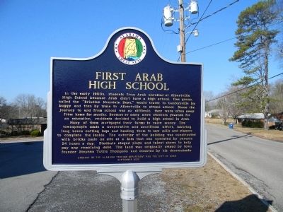
First Arab High School
In the early 1900s, students from Arab enrolled at Albertville High School because Arab didn’t have a high school. One group, called the “Brindlee Mountain Boys”, would travel to Guntersville by buggy and then by train to Albertville to attend school. Since the journey to and from school was so difficult, they were often away from home for months. Because so many more students yearned for an education, residents decided to build a high school in Arab. Many of them mortgaged their farms to raise money. The townspeople made a cooperative and sacrificial effort, laboring long hours cutting logs and hauling them to saw mills and planers to complete the inside. The exterior of the building was constructed with bricks made on site at a kiln that was operated by parents 24 hours a day. Students staged plays and talent shows to help pay any remaining debt. The land was originality owned by town founder Stephen Tuttle Thompson and donated by his descendants.
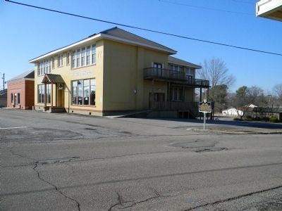
First Arab Auditorium.
In 1936, the auditorium adjacent to the high school was constructed with funding from the federal government. Both facilities
this page online
Erected 2010 by Alabama Tourism Department and the City of Arab.
Topics and series. This historical marker is listed in this topic list: Education. In addition, it is included in the Alabama Tourism Department series list. A significant historical year for this entry is 1936.
Location. Marker has been reported missing. It was located near 34° 19.251′ N, 86° 29.791′ W. Marker was in Arab, Alabama, in Marshall County. It was at the intersection of 4th Avenue NW and 1st Street NW, on the left when traveling west on 4th Avenue NW. Touch for map. Marker was at or near this postal address: 323 1st St NW, Arab AL 35016, United States of America. Touch for directions.

Regionally, this marker was in North Alabama. It was also in the American South, specifically

Photographed by Jimmy Emerson, 2010
2. First Arab Auditorium Marker - Reverse Side
Other nearby markers. At least 8 other markers are within 2 miles of this location, measured as the crow flies: First Arab Town Hall (about 600 feet away, measured in a direct line); 1883 Methodist Church Cemetery (about 700 feet away); First Baptist Church (approx. 0.2 miles away); Farmer's Exchange (approx. ¼ mile away); Stephen Tuttle Thompson (approx. 0.3 miles away); First United Methodist Church (approx. one mile away); Bear Meat Cabin Road (approx. 1.4 miles away); Gilliam Springs Baptist Church (approx. 1½ miles away). Touch for a list and map of all markers in Arab.
Photographed by Judith Barber, February 5, 2011
3. First Arab High School Marker

Photographed by Jimmy Emerson, December 26, 2025
4. Site of First Arab High School / First Arab Auditorium Marker
The marker is missing in the photo.
Credits. This page was last revised on December 30, 2025. It was originally submitted on March 3, 2011, by Judith Barber of Marietta, Georgia. This page has been viewed 1,971 times since then and 85 times this year. Last updated on November 29, 2024, by Edward Troxel of Creal Springs, Illinois. Photos: 1. submitted on March 3, 2011, by Judith Barber of Marietta, Georgia. 2. submitted on December 20, 2025, by Jimmy Emerson of Dalton, Georgia. 3. submitted on March 3, 2011, by Judith Barber of Marietta, Georgia. 4. submitted on December 26, 2025, by Jimmy Emerson of Dalton, Georgia. • Devry Becker Jones was the editor who published this page.
