
Edam in Edam-Volendam, North Holland, Netherlands — Northwestern Europe
Fort bij Edam
| — | Stelling van Amsterdam | — |

Photographed by Andrew Ruppenstein, October 27, 2024
1. Fort bij Edam Marker

Oorspronkelijke functie
Verdediging van de Zuiderzeedijk, zowel ten noorden als ten zuiden van Edam. Bescherming van de direct achter het fort gelegen zeesluis, die een belangrijk inlaatpunt was voor inundatiewater. Via de nog bestaande pompsluis in het stadje Edam kon de polder De Zeevang in zijn geheel onder water worden gezet.
Staatsbosbeheer en het Fort bij Edam
Staatsbosbeheer bezit en beheert naast natuur ook monumenten. Monumenten zoals forten kwamen vooral vanaf 1960 in eigendom omdat Defensie ze afstootte. Het Fort bij Edam is hiervan een voorbeeld. Staatsbosbeheer wil het fort bewaren en toegankelijk maken voor publiek. De landschappelijke schoonheid en cultuurhistorische waarden maken de forten van de Stelling van Amsterdam uniek. De omgeving van de forten is door de jaren heen groen en ongerept gebleven. Dit is met name te danken aan de ‘Kringenwet’, die tot 1963 bleef bestaan. Deze wet zorgde ervoor dat in de omgeving van een fort niet mocht worden gebouwd.
Een groep enthousiaste vrijwilligers, verenigd in de Stichting Fort bij Edam, ondersteunt bij het beheer van het fort en het fortterrein. Deze stichting houdt zich bezig met het onderhoud van het fortgebouw, het geven van rondleidingen tijdens openstellingen of op afspraak en het organiseren van passende evenementen op het fort. Enkele ruimtes zijn opnieuw ingericht, in andere lokalen zijn tentoonstellingen, o.a. over de beide wereldoorlogen.
Kijk voor openstellingen, rondleidingen en verdere informatie op www.fortbijedam.nl.
(English translation of Dutch text in green and blue fields)
Since the flooding was easy to carry out in the northern part of the Defence Line, the forts were completed later than in other parts of the Defence Line: between 1907 and 1914. The defensible earthwork of Fort bij Edam was already ready in 1895, but the bombproof building only followed in 1912 according to the renewed standard design. In Fort bij Edam, however, the frontal guns were not in retractable cupolas, but in an armoured casemate. This was connected to the main building by a covered, concrete corridor (poterne). During the mobilisation period, the fort had a garrison of 253 men. Today, the kitchen is still remarkably complete. The large cooking kettles and boiler are still present.
Original function
Defense of the Zuiderzeedijk, both north and south of Edam. Protection of the sea lock located directly behind the fort, which was an important inlet point for inundation water. The polder De Zeevang could be completely flooded via the still existing pumping lock in the town of Edam.
Staatsbosbeheer and the Fort at Edam
In addition to nature, Staatsbosbeheer also owns and manages monuments. Monuments such as forts mainly came into ownership from 1960 onwards because Defence sold them off. The Fort bij Edam is an example of this. Staatsbosbeheer wants to preserve the fort and make it accessible to the public. The scenic beauty and cultural-historical values make the forts of the Defence Line of Amsterdam unique. The area around the forts has remained green and unspoilt over the years. This is mainly due to the ‘Kringenwet’, which remained in force until 1963. This law ensured that no construction was allowed in the vicinity of a fort.
A group of enthusiastic volunteers, working as the Fort bij Edam Foundation, supports the management of the fort and the fort grounds. This foundation is involved in the maintenance of the fort building, giving guided tours during openings or by appointment and organising suitable events at the fort. Some rooms have been redecorated, and other rooms house exhibitions, including ones about both world wars.
For opening times, guided tours and further information, visit www.fortbijedam.nl.
———-
Erected by Provincie
this page online
Topics. This historical marker is listed in this topic list: Forts and Castles. A significant historical year for this entry is 1907.
Location. 52° 30.971′ N, 5° 4.097′ E. Marker is in Edam, Noord-Holland (North Holland), in Edam-Volendam. It is on Oorgat, on the left when traveling east. Touch for map. Marker is at or near this postal address: Oorgat 10, Edam, Noord-Holland 1135 CP, Netherlands. Touch for directions.

Regionally, it is in Europe, the European Union, Atlantic Europe, the Benelux Low Countries, the Schengen Area, Western Europe, and the Western World. Historically, it finds itself in what was once the Roman Empire and specifically also the Holy Roman Empire.
Other nearby markers. At least 8 other markers are within walking distance of this marker: Oosterpoort / East Gate (approx. 0.7 kilometers away); Heilige Nicolaaskerk / St. Nicholas Church (approx. 1.1 kilometers away); Lise Leijser (approx. 1.2 kilometers away); Fanny Kusiel-Gutmann (approx. 1.2 kilometers away); Josef Steinberg (approx. 1.2 kilometers away); Salomon Kaufmann (approx. 1.2 kilometers away); Julie Kaufmann-Hirschheimer
Photographed by Andrew Ruppenstein, October 27, 2024
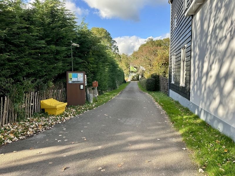
2. Fort bij Edam Marker - wide view
The marker here is visible on the left side of the driveway leading from Oorgat to the fort.
Also see . . .
1. Fort bij Edam (Fort bij Edam, in Dutch). This is the page referenced on the marker itself. It contains a short history of the fort in Dutch, plus a minimum amount of information in English, German and French about visiting the fort. (Submitted on December 3, 2024.)
2. Fort bij Edam (Oneindig Noord-Holland, in Dutch). This is the website referenced by the QR code on the marker. Excerpt - Postwar Fort bij Edam (in translation):
Shortly after the Second World War, the Fort at Edam experienced the most notorious period in its history. Immediately after the liberation, the fort served as a prison for women who had ties to the NSB or German soldiers. In the summer of 1945, a group of women were held captive at the fort, under difficult circumstances. One of the women even gave birth at the fort.(Submitted on December 3, 2024.)
Edam is one of the forts of the Defence Line of Amsterdam that were used as a temporary prison for 'bad' Dutch people immediately after the liberation.In the Fort north of Purmerend, men who had collaborated with the Nazis were held for some time. The Fort near Edam was later also used as ainternment campfor convicted collaborators. For this purpose, bars were placed in the fort. Because the number of convicts decreased significantly after 1946, the fort was not used for this purpose for long.Photographed by Andrew Ruppenstein, October 27, 20243. Fort bij Edam as seen through the gate
From 1948, the Fort bij Edam served as an ammunition storage facility for the Ministry of Defence, a function that most of the forts were given after the war. In 1951, a shooting range was built on the fort grounds, which was used by the National Reserve and the police, among others. Until a few years ago, this shooting range was also used by a local shooting club. In 1986, the Ministry of Defence transferred the fort to Staatsbosbeheer. Because the fort grounds had hardly been used for years, there were now special flora and fauna to be found. Part of the grounds were therefore given the status of protected nature reserve.


Photographed by Andrew Ruppenstein, October 27, 2024
4. Marker detail: map of the Stelling van Amsterdam
The map shows the location of forts and batteries along Amsterdam’s defensive line, with Fort bij Edam’s position visible here in the upper right.
Credits. This page was last revised on December 3, 2024. It was originally submitted on December 3, 2024, by Andrew Ruppenstein of Lamorinda, California. This page has been viewed 82 times since then and 4 times this year. Photos: 1, 2, 3, 4. submitted on December 3, 2024, by Andrew Ruppenstein of Lamorinda, California.
