Carolina Beach in New Hanover County, North Carolina — The American South (South Atlantic)
Fort Fisher Army Air Base Hutment
1942
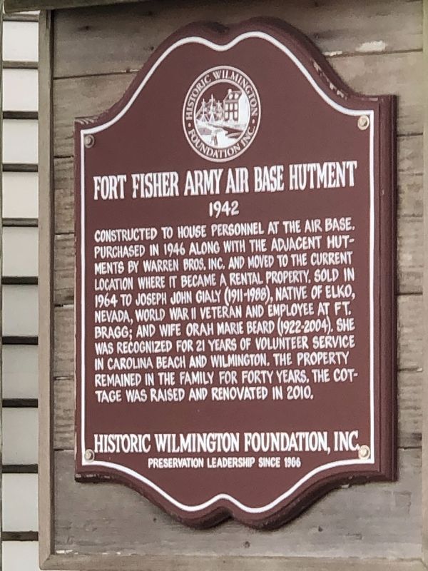
Photographed by Duane and Tracy Marsteller, November 22, 2024
1. Fort Fisher Army Air Base Hutment Marker
Erected by Historic Wilmington Foundation, Inc.
Topics and series. This historical marker is listed in these topic lists: Architecture • Charity & Public Work • Industry & Commerce. In addition, it is included in the North Carolina, Historic Wilmington Foundation series list. A significant historical year for this entry is 1942.
Location. 34° 2.841′ N, 77° 53.2′ W. Marker is in Carolina Beach, North Carolina, in New Hanover County. It is at the intersection of Carolina Beach Avenue North and Scotch Bonnet Lane, on the right when traveling south on Carolina Beach Avenue North.
this page online

Regionally, this marker is in the Coastal Plain and on the Cape Fear Coast. It is also in the American South, specifically in the Upper South, in the Tidewater, and on the Eastern Seaboard. Globally, it is in the North Atlantic Region, North America, the Western Hemisphere, the Western World, and the Anglosphere. Historically, it finds itself in what was once the territory of the Mississippian Culture, one of the original Thirteen Colonies, one of the Confederate States of America, and the Antebellum South.
Other nearby markers. At least 8 other markers are within walking distance of this marker: Civil War Fortifications (approx. 0.3 miles away); Sugar Loaf Line (approx. half a mile away); For a little while it was a lively and interesting fight (approx. 0.6 miles away); Joseph Ryder Lewis Jr. Civil War Park (approx. 0.6 miles away); Battlefield of Sugar Loaf (approx. 0.6 miles away); I hope we can hold Wilmington (approx. 0.6 miles away); We are strongly entrenched here...

Photographed by Duane and Tracy Marsteller, November 22, 2024
2. Fort Fisher Army Air Base Hutment Marker
Credits. This page was last revised on December 6, 2024. It was originally submitted on December 5, 2024, by Duane and Tracy Marsteller of Murfreesboro, Tennessee. This page has been viewed 171 times since then and 28 times this year. Photos: 1, 2. submitted on December 5, 2024, by Duane and Tracy Marsteller of Murfreesboro, Tennessee.
