
Agua Dulce in Los Angeles County, California — The American West (Pacific Coastal)
Land and Industry
In the Late 1800s
| — | Vasquez Rocks | — |
Photographed by Craig Baker, December 9, 2024
1. Land and Industry Marker
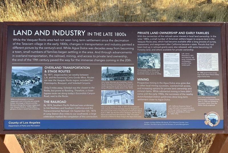
While the Vasquez Rocks area had not seen long term settlement since the decimation of the Tataviam village in the early 1800s, changes in transportation and industry painted a different picture by the century's end. While Agua Dulce was decades away from becoming a town, small numbers of families began settling in the area. And through advancements in overland transportation, the railroad, mining, and access to private land ownership, the end of the 19th century paved the way for the immense changes coming in the 20th.
Overland Transportation & Stage Routes
By 1871, stagecoaches ran weekly between LA. and the booming Cerro Gordo Mine. Routes ran near the Vasquez Rocks region included San Francisquito, Bouquet, and Soledad Canyons. Only 2 miles away, Soledad was the closest to the Rocks, but prone to flooding. Therefore, a closer bypass route ran along today's Escondido Canyon Road, next to the Rocks.
The Railroad
By 1874, Southern Pacific Railroad was underway to link Northern and Southern California and the Transcontinental Railroad. On September 5th, 1876 at Lang Station
this page online
Private Land Ownership and Early Families
With the connection of the railroad came interest in local land ownership. In the latter 1880s, a small number of American settlers began to acquire land in the Vasquez Rocks area, which had become available after a long process of survey, assessment, and assignment after California became a state. Parcels that had been tied up in railroad grants were also released, with some becoming US Forestry land, and others available for private ownership.
Mining
Prospective mining in the Agua Dulce area grew due to other local mining successes, overland trail access, and increasing options for private land ownership and mineral claims. While substantial mining in here didn't come until the early 1900s, the successes of the nearby Acton/Soledad District goldmines drew long-term settlement closer to Agua Dulce.
photo captions:
· While no photographs of historic stagecoach runs in this area are currently known, this image of Monte and Ellie Montana driving
Photographed by Craig Baker, December 9, 2024
2. Marker Detail
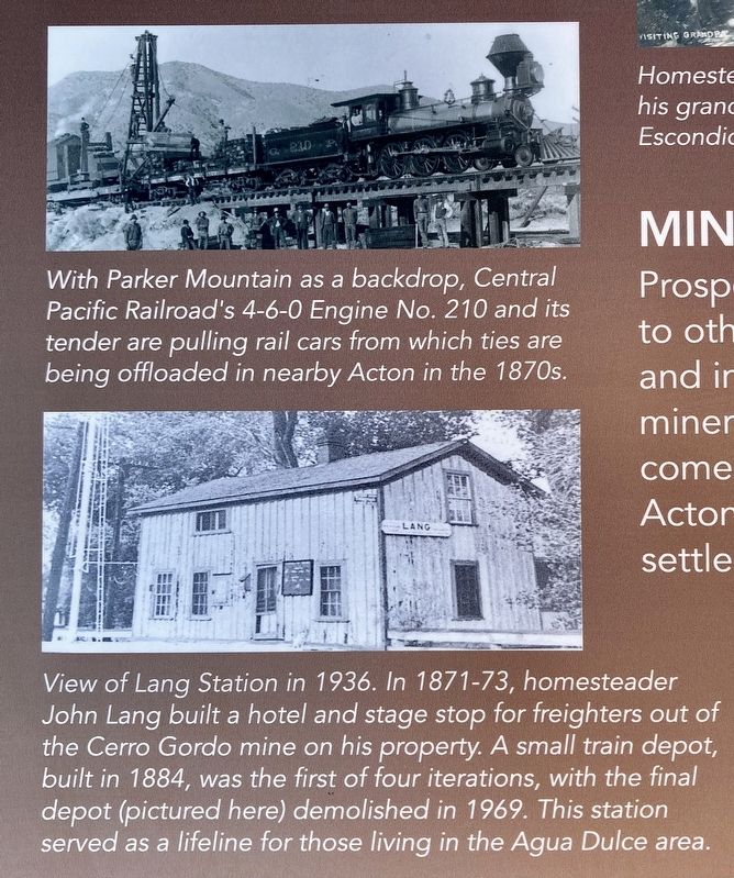
· With Parker Mountain as a backdrop, Central Pacific Railroad’s 4-6-0 Engine No. 210 and its tender are pulling rail cars from which ties are being offloaded in nearby Acton in the 1870s.
· View of Lang Station in 1936. In 1871-73, homesteader John Lang built a hotel and stage stop for freighters out of Cerro Gordo mine on his property. A small train depot, built in 1884, was the first of four iterations, with the final depot (pictured here) demolished in 1969. This station served as a lifeline for those in the Agua Dulce area.
· Homesteader Albert Mellen and his grandchildren on his nearby Escondido Canyon ranch (1890s).
· James Robertson's 1891 land deed for 160 acres, including the northwestern portion of today's park.
· An 1880 government survey map of the Sierra Pelona Valley (Agua Dulce) area.
· One of the earliest known photographs of Vasquez Rocks, taken an 1898 and labeled as Escondido Cañon, from the Mellon family scrapbook.
· California Governor Henry
Photographed by Craig Baker, December 9, 2024
3. Land and Industry Marker
Images courtesy Melen-Bly family, SCV Historical Society, Leon Worden, the Blum family, and the Bureau of Land Management.
Erected 2024 by County of Los Angeles Department of Parks and Recreation.
Topics. This historical marker is listed in these topic lists: Industry & Commerce • Settlements & Settlers. A significant historical date for this entry is September 5, 1876.
Location. 34° 29.291′ N, 118° 18.832′ W. Marker is in Agua Dulce, California, in Los Angeles County. It can be reached from Escondido Canyon Road half a mile east of Agua Dulce Canyon Road, on the right when traveling east. Located in Vazquez Rocks Natural Area, on the Pacific Crest Trail/Homestead Trail. Touch for map. Marker is at or near this postal address: 10700 Escondido Canyon Rd, Santa Clarita CA 91390, United States of America. Touch for directions.

Regionally, this marker is in Greater Los Angeles and in the Transverse Ranges. It is also on the American Pacific Coast. Globally, it is in North America, on the Ring of Fire,
Photographed by Craig Baker, December 9, 2024
4. Land and Industry Marker
Other nearby markers. At least 11 other markers are within walking distance of this marker: The Mexican & Early American Eras (about 500 feet away, measured in a direct line); European Contact & the Spanish Era (about 800 feet away); How Do We Know What We Know? (approx. 0.3 miles away); The Krieg-Toney Family (approx. 0.3 miles away); Vasquez Rocks Becomes a Park (approx. 0.3 miles away); Pacific Crest Trail (approx. 0.3 miles away); The Castle of Vasquez Rocks (approx. 0.3 miles away); The Asher Family (approx. 0.4 miles away); "Devil’s Punchbowl Wildlife" Mural (approx. 0.4 miles away); Toney Residence (approx. 0.4 miles away); The Village of Mapipinga (approx. 0.4 miles away). Touch for a list and map of all markers in Agua Dulce.
Credits. This page was last revised on December 17, 2024. It was originally submitted on December 9, 2024, by Craig Baker of Sylmar, California. This page has been viewed 183 times since then and 17 times this year. Photos: 1, 2, 3, 4. submitted on December 9, 2024, by Craig Baker of Sylmar, California.
