North Central in Virginia Beach, Virginia — The American South (Mid-Atlantic)
Francis Land House
Photographed by Laura Troy, September 21, 2007
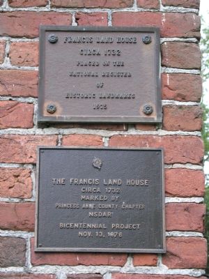
1. Francis Land House Marker
The Francis Land House, circa 1732. Marked by Princess Anne County Chapter, NSDAR, Bicentennial Project, Nov. 13, 1976.
Erected 1976 by Princess Anne County Chapter, National Association, Daughters of the American Revolution.
Topics and series. This historical marker is listed in this topic list: Notable Buildings. In addition, it is included in the Daughters of the American Revolution (DAR) series list. A significant historical date for this entry is October 13, 1852.
Location. 36° 50.529′ N, 76° 4.777′ W. Marker is in Virginia Beach, Virginia. It is in North Central. It is on Virginia Beach Boulevard (U.S. 58) east of Kings Grant Road, on the right when traveling west. Touch for map. Marker is in this post office area: Virginia Beach VA 23452, United States of America. Touch for directions.

Regionally, this marker is in Hampton Roads, specifically in Coastal Virginia, and in the Hampton Roads Metropolitan Area. It is also in the American South, specifically in the Upper South, in the Tidewater, and on the Eastern Seaboard.
this page online
Other nearby markers. At least 8 other markers are within 3 miles of this marker, measured as the crow flies: VFW Veterans Memorial (approx. 1.8 miles away); History of Thalia / Aunt Penny's Park (approx. 2 miles away); Camp Ashby (approx. 2.3 miles away); Spring Water Cistern (approx. 2½ miles away); Ferry Plantation House (approx. 2½ miles away); Grace Sherwood (approx. 2½ miles away); Lake Trashmore Bank Stabilization (approx. 2.6 miles away); Seal of the City of Virginia Beach (approx. 2.7 miles away). Touch for a list and map of all markers in Virginia Beach.
Photographed by Scott Rollins, June 22, 2009
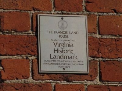
2. Francis Land House Marker
The Francis Land House has been registered as a Virginia Historic Landmark pursuant to the authority vested in the Virginia Historic Landmarks Commission Act of 1966.
Photographed by Laura Troy, September 21, 2007
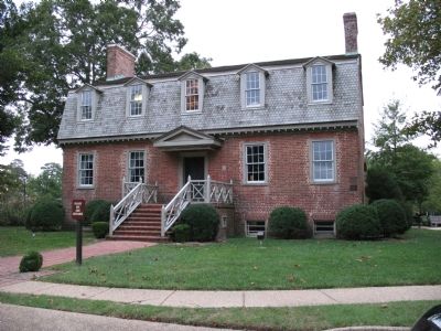
3. Francis Land House
Credits. This page was last revised on February 1, 2023. It was originally submitted on September 21, 2007, by Laura Troy of Burke, Virginia. This page has been viewed 2,295 times since then and 40 times this year. Photos: 1. submitted on September 21, 2007, by Laura Troy of Burke, Virginia. 2. submitted on July 24, 2009, by Kristin Rollins of Portsmouth, Virginia. 3. submitted on September 21, 2007, by Laura Troy of Burke, Virginia. • J. J. Prats was the editor who published this page.
