Tuscaloosa in Tuscaloosa County, Alabama — The American South (East South Central)
Newtown

Photographed by Cosmos Mariner, September 19, 2024
1. Newtown Marker
Newtown — bounded on the east by 32nd Ave., west by Snow Terrace, south by 15th St., north by Black Warrior River — surveyed before Tuscaloosa — incorporated December 20, 1820 as “The lower part of Tuscaloosa” — built on part of Section 21, a portion of Land Grant signed by President Monroe, to the Connecticut Deaf and Dumb Asylum.
1822 — County Court House and Jail moved to Newtown.
1828 — Newtown annexed to Tuscaloosa.
1842 — Newtown destroyed by tornado.
1982 — Former Newton area officially designated as “Newtown” by a resolution of Tuscaloosa Commission.
1986 — Newtown recognized by Tuscaloosa as a historical site.
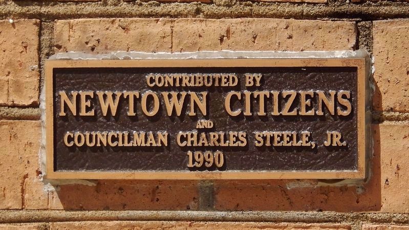
Erected 1990 by Newtown Citizens and Councilman Charles Steele, Jr.
Topics and series. This historical marker is listed in these topic lists: Disasters • Political Subdivisions. In addition, it is included in the Former U.S. Presidents: #05 James Monroe series list. A significant historical date for this entry is December 20, 1820.
Location. 33° 12.339′ N, 87° 34.624′ W. Marker is in Tuscaloosa, Alabama, in Tuscaloosa County. It is at the intersection of 7th Street and Martin Luther King, Jr. Boulevard, on the right
this page online

Regionally, this marker is in the American South and specifically in the Deep South. Globally, it is in North America, a Gulf of Mexico state, the Western Hemisphere, the Western World, and the Anglosphere. Historically, it finds itself in what was once the territory of the Mississippian Culture, one of the Confederate States of America, and the Antebellum South.
Other nearby markers. At least 8 other markers are within walking distance of this marker: Browne House (approx. 0.2 miles away); McGuire~Strickland House (approx. 0.2 miles away); Honor Roll of Soldiers and Patriots of the American Revolution (approx. 0.2 miles away); John Murphy (approx. 0.2 miles away); Gabriel Moore (approx. 0.2 miles away); Samuel B. Moore (approx. 0.2 miles away); John Gayle (approx. 0.2 miles away); Alabama Central Female College (approx. 0.2 miles away). Touch for a list and map of all markers
Photographed by Cosmos Mariner, September 19, 2024
2. Newtown Marker
Contributed by Newtown Citizens and Councilman Charles Steele, Jr. 1990
Also see . . . Newtown: The Story of Tuscaloosa’s Bygone Rival.
(By: Mark Robison, University of Alabama Information Services Librarian) Excerpt: Newtown was a true rival to Tuscaloosa. Matt Clinton writes, “Newtown was surveyed before Tuscaloosa and consequently grew faster than ‘Old Town’” (Scrapbook 33). In 1822 the citizens voted to move the county seat from Tuscaloosa to Newtown, where a courthouse was constructed at the present-day southwestern corner of Martin Luther King, Jr., Blvd. and 6th Street. Newtown was a hub of economic activity in those days, with several businesses lining its Main Street (36th Ave.), including law offices, doctors’ offices, a hotel and a market house located in the center of the street. Nearer the river stood a cigar factory, a sawmill and a warehouse. Newtown even had its own ferry service to Northport.(Submitted on December 22, 2024, by Cosmos Mariner of Cape Canaveral, Florida.)Tuscaloosa became the state capital in 1826, and an act of the state legislature greatly extended Tuscaloosa’s boundaries, thereby ending Newtown’s separate existence. Even today, however, the effects of Newtown’s history are visible. At Martin Luther King, Jr., Blvd.,
which formed the north-south border between the towns, the east-west streets make a notable jag, becoming more square on the Newtown side.Photographed by Cosmos Mariner, September 19, 20243. Newtown MarkerLooking northwest; 7th Street is to the left and Martin Luther King, Jr. Boulevard crosses in the background.

Credits. This page was last revised on December 28, 2024. It was originally submitted on December 22, 2024, by Cosmos Mariner of Cape Canaveral, Florida. This page has been viewed 237 times since then and 33 times this year. Photos: 1, 2, 3. submitted on December 22, 2024, by Cosmos Mariner of Cape Canaveral, Florida.
