Sparta in Van Buren County, Tennessee — The American South (East South Central)
Haston Station
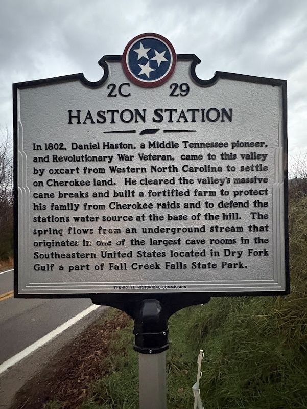
Photographed by Darren Jefferson Clay, December 29, 2024
1. Haston Station marker
Erected 2024 by Tennessee Historical Commission. (Marker Number 2C 29.)
Topics. This historical marker is listed in this topic list: Settlements & Settlers.
Location. 35° 48.117′ N, 85° 26.624′ W. Marker is in Sparta, Tennessee, in Van Buren County. It is on Cane Creek-Cummingsville Road, on the right when traveling east. Touch for map. Marker is at or near this postal address: 894 Cane Creek-Cummingsville Rd, Sparta TN 38583, United States of America. Touch for directions.

Regionally, this marker is in Tennessee’s Cumberland Plateau
this page online
Other nearby markers. At least 8 other markers are within 9 miles of this marker, measured as the crow flies: Bragg’s March to Kentucky (approx. 2 miles away); War on the Plateau (approx. 4 miles away); Van Buren County Civil War Monument (approx. 4 miles away); Van Buren County Veterans Memorial (approx. 4 miles away); Van Buren County Veterans Monument (approx. 4 miles away); Burritt College (approx. 4 miles away); George Gibbs Dibrell (approx. 8.4 miles away); The Rock House (approx. 8½ miles away). Touch for a list and map of all markers in Sparta.

Photographed by Darren Jefferson Clay, December 29, 2024
2. Haston Station marker
Credits. This page was last revised on December 30, 2024. It was originally submitted on December 29, 2024, by Darren Jefferson Clay of Duluth, Georgia. This page has been viewed 587 times since then and 88 times this year. Photos: 1, 2. submitted on December 29, 2024, by Darren Jefferson Clay of Duluth, Georgia. • James Hulse was the editor who published this page.
