Lake Township near Council Bluffs in Pottawattamie County, Iowa — The American Midwest (Upper Plains)
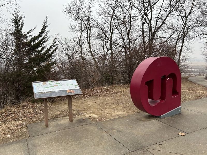
The Lewis & Clark Expedition
| — | Lewis and Clark National Historic Trail | — |

December 26, 2024
1. The Lewis & Clark Expedition Marker
The landscape has changed since Lewis and Clark explored it: rivers have been dammed, forests cut over, prairies plowed under, and roads built to the horizon. Although remnants of wilderness still exist, imagine this land as Lewis and Clark first saw it two centuries ago. Today, visitors can travel in the footsteps of Lewis and Clark to share in the diverse perspectives of the Expedition and to gain a better understanding of the history of the United States.
Meriwether Lewis
William Clark
In preparation for the journey, Meriwether Lewis took crash courses in medicine, botany, zoology, and celestial observation. With President Jefferson's permission, Lewis asked his friend and former commanding officer, William Clark, to be co-leader. Clark brought his skills as an outdoorsman, a geographer
this page online
Map captions, in chronological order:
Lewis and Clark outbound journey, 1804-1805 [in green]:
Depart Camp River Dubois
(winter quarters, 1803-1804)
May 14, 1804
First Council with Indians
(Otoes and Missourias)
August 3, 1804
Sgt. Charles Floyd Dies
August 20, 1804
Confrontation with the Teton Sioux
September 25-28, 1804
Fort Mandan is constructed
Toussaint Charbonneau, Sacagawea and their son Jean Bapiste join the Expedition.
(winter quarters, 1804-1805)
Decision Point
Lewis and Clark correctly determine the Missouri River route ahead to the Great Falls
June 2, 1805
Portage around the Great Falls of the Missouri River
June 13-July 15, 1805
Purchase horses from Shoshone Indians, ensuring a safe passage through the Bitterroot Mountains
August 30, 1805
Nez Perce help Lewis and Clark prepare for their journey to the Columbia River
September 26-October 7, 1805
Arrive at the Pacific Ocean
November 15, 1805
Lewis and Clark return journey, 1806 (route shown where different from outbound journey) [in brown]:
Fort Clatsop is constructed
(winter quarters, 1805-1806)
Return trip begins on March 23, 1806
Expedition Splits
Lewis and party head north to explore the Marias River.
Clark and party head south and follow the Yellowstone River.
July 3, 1806
Clark return journey, [dashed line]:
Clark engraves his name on the side of a sandstone butte along the Yellowstone River
July 25, 1806
Lewis return journey, [dotted line]:
Two Medicine Fight Site
Clash results in the deaths of two Blackfeet Indians
July 27, 1806
Lewis and Clark parties rejoin
August 12, 1806
Arrive in St. Louis
September 23, 1806
Map legend caption:
Some Indian Nations who lived along the Missouri River during the Lewis and Clark expedition were later relocated to Oklahoma. These include the Delaware, Kaw, Osage, Otoe-Missouria, Pawnee, Ponca, Potawatomi, and Shawnee.
Erected by National
December 26, 2024
2. The Lewis & Clark Expedition Marker
Topics and series. This historical marker is listed in this topic list: Exploration. In addition, it is included in the Lewis & Clark Expedition series list. A significant historical year for this entry is 1804.
Location. 41° 18.201′ N, 95° 51.483′ W. Marker is near Council Bluffs, Iowa, in Pottawattamie County. It is in Lake Township. It can be reached from Monument Road 0.8 miles north of Mynster Springs Road, on the left when traveling north. Located at the Lewis and Clark Monument Park. Touch for map. Marker is at or near this postal address: 19962 Monument Rd, Council Bluffs IA 51503, United States of America. Touch for directions.

Regionally, this marker is in Western Iowa, in Loess Hills, and in Greater Omaha. It is also in the American Midwest, in the Lewis & Clark Corridor, and in the Corn Belt. Globally, it is in North America, the Western Hemisphere, the Western World, and the Anglosphere. Historically, it finds itself in what was once the territory of the Mississippian Culture and also the Louisiana Purchase.
Other nearby markers. At least 8 other markers are within 3 miles of this marker, measured as the crow flies: Lewis and Clark Monument (a few steps from this marker); Anticipating an Indian Council (within shouting distance of this marker); Like A Bald Man’s Head (within shouting distance of this marker); Colonel William H. Kinsman (approx. 2.2 miles away); (missing) ... Was York (approx. 2½ miles away in Nebraska); Profitable Possibilities (approx. 2½ miles away in Nebraska); Abraham Lincoln's 1859 Visit (approx. 2½ miles away); Kanesville Mormon Cemetery (approx. 2½ miles away). Touch for a list and map of all markers in Council Bluffs.
Other markers no longer nearby. The Lewis and Clark Expedition (was here, next to this marker but has been replaced with another marker now near it); Anticipating An Indian Council (was within shouting distance of this marker but has been replaced with another marker now near it).
Related marker. Click here for another marker that is related to this marker.
Credits. This page was last revised on February 7, 2025. It was originally submitted on January 13, 2025. This page has been viewed 458 times since then and 29 times this year. Photos: 1, 2. submitted on January 13, 2025.
