Passendale in West-Vlaanderen, Flanders, Belgium — Northwestern Europe
Dorpskern Passendale 1917
2014-18
| — | 100 jaar Groot Oorlog | — |
Photographed by Steve Stoessel, November 12, 2024
1. Dorpskern Passendale 1917 Marker
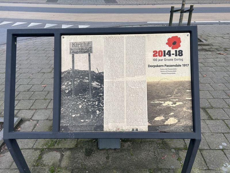
In 1914, amper acht jaar na een grondige verbouwing, boort een eerste granaat zich in de kerktoren van Passendale. De volgende drie jaar wordt de kerk relatief gespaard. Maar tijdens het offensief van 1917 wordt de gehavende kerk onherroepelijk tot puin geschoten. Na hevige beschietingen banen de Canadezen van het 27nd Battalion uit Winnipeg op 6 november vanaf Crest Farm zich een weg naar de kerk. Vervolgens dienen ze het achterliggend gebied in te nemen. In het kraterlandschapondervindenzehevigeweerstand van sluipschutters. Anderhalf uur na het begin van de aanval wordt het eindobjectief bereikt. Voor hen ligt een ondoordringbaar moeras. In de verte zien ze Roeselare liggen, een schril contrast met het maanlandschap achter hen. De volgende dag wordt het duidelijk dat beide zijden grote verliezen hebben geleden. Aan de kerk alleen al worden 76 dode Duitsers geteld en de vele gesneuvelde Canadezen moet men ter plaatse begraven. Het is immers onmogelijk om ze via de onbegaanbare wegen af te voeren. Intussen blijven de Duitsers de dorpskern bestoken. Bij de kerkruïne wordt een "lamp visual station" geplaatst. Zo kan men doorheen
this page online
Ruine de Passendale
En 1914 et seulement huit ans après les travaux de transformation approfondie, un premier obus perce la tour de l'église de Passendale. Les trois années suivantes l'église est épargnée plus ou moins mais elle est irrévocablement réduite en ruine pendant l'offensive de 1917. Après de longues canonnades les Canadiens du 27lème Bataillon de Winnipeg se frayent un chemin de Crest Farm vers l'église. Ensuite ils doivent conquérir la région située derrière le village. La résistance des tireurs d'élite est intense dans ce paysage de cratères. Ils atteignent l'objectif final une heure et demie après le lancement de l'attaque. Les marécages qui se trouvent devant eux sont impénétrables. Le lendemain
Photographed by Steve Stoessel, November 12, 2024
2. Dorpskern Passendale 1917 Marker
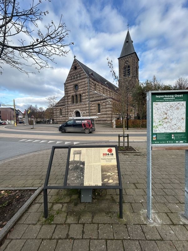
This view of the church is the from the same perspective as the photo of the ruined church on the marker.
Ruins of Passendale
In 1914, just eight years after a major renovation, a first shell penetrated the church of Passendale. The church was more or less spared for the following three years. But
Photographed by Steve Stoessel, November 14, 2024
3. The Mud of Flanders.
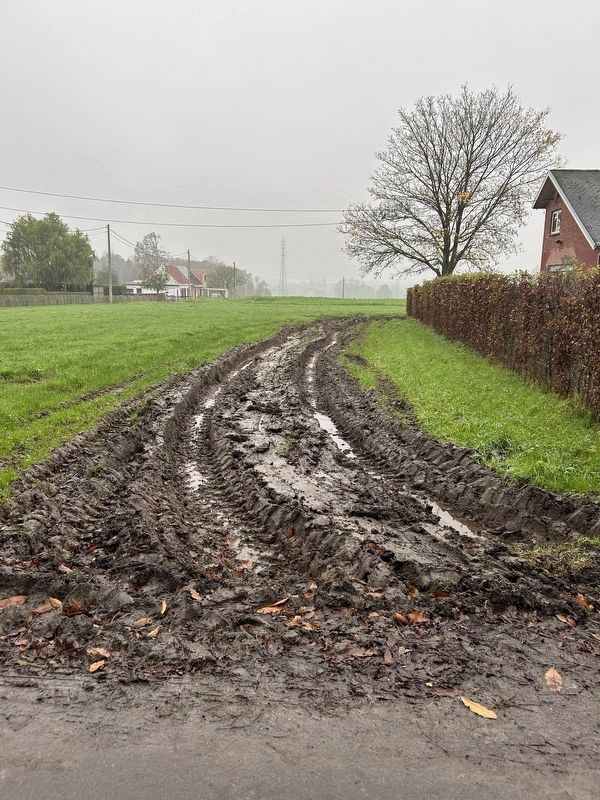
This is a picture of a field in Zonnenbeke after a light rain. The soil is a heavy viscous clay that becomes very slippery when wet. (Personal experience here.) A hallmark of the Passendale campaign was mud so thick and deep that men drowned in it.
Ruine Passendale
1914, nur acht Jahre nach einer gründlichen Renovierung, bohrt eine erste Granate sich in den Kirchturm von Passendale. Die nächsten drei Jahre bleibt die Kirche relativ verschont. Aber während der Offensive 1917 wird die angeschlagene Kirche unwiderruflich zu Schutt geschossen. Nach schwerem Beschuss bahnen die Kanadier des 27. Batallion aus Winnipeg sich am 6. November von Crest Farm aus einen Weg zur Kirche, Danach müssen sie das dahinterliegende Gebiet erobern. In der Kraterlandschaft begegnet ihnen heftiger Widerstand von Scharfschützen. Eineinhalb Stunden nach Beginn des Angriffs wird das Endziel erreicht. Vor ihnen liegt ein undurchdringbarer Sumpf. In der Ferne sehen sie Roeselare liegen, ein starker Kontrast mit der Mondlandschaft hinter ihnen. Am nächsten Tag es wird deutlich, dass beide Seiten große Verluste erlitten haben. Allein an der Kirche werden 76 tote Deutsche gezählt und viele gefallene Kanadier muss man an Ort und Stelle begraben. Es ist schlicht unmöglich um sie über die unbegehbaren Wege zu bergen. Inzwischen beschießen die Deutschen den Dorfkern weiter. An der Kirchenruine wird eine "lamp visual station" eingerichtet. So kann man schnell durch den vielen Rauch mit dem Hauptquartier bei Tyne Cot kommunizieren. Die Kanadier bleiben hier bis Mitte November, nach einem letzten Angriff nördlich des Dorfes am 10. November. Nach dem Krieg wird die Kirche nach dem Vorkriegsentwurf wieder aufgebaut. Begraben unter Tonnen von Schutt werden beim Wiederaufbau viele Steine, wie Eisensandstein aus dem 11. Jahrhundert. wiederverwendet. Diese findet man heute im Seitenflügel und in der Abgrenzung des Freidhofs.
[Photo Captions]
Enkel aan het bord is in 1918 nog te zien waar de kerk stond.
Seul le panneau indique où se trouvait l'église en 1918.
Only the sign indicates where the church was in 1918.
Nur am Schild ist 1918 noch zu sehen wo die Kirche stand
Zicht vanaf de kerk op de Passendalestraat, 1918.
Vue en direction de la Passendalestraat depuis l'église, 1918.
View on the Passendalestraat from the church, 1918.
Aussicht von der Kirche aus auf die Passendalestraat, 1918
Topics. This historical marker is listed in these topic lists: Religion & Religious Structures • Settlements & Settlers • War, World I. A significant historical year for this entry is 1914.
Location. 50° 54.008′ N, 3° 1.245′ E. Marker is in Passendale, Vlaanderen (Flanders), in West-Vlaanderen. It is at the intersection of Statiestraat (National Route 303) and Canadalaan, on the left when traveling south on Statiestraat. Touch for map. Marker is at or near this postal address: Statiestraat 1A, Passendale, Vlaanderen 8980, Belgium. Touch for directions.

Regionally, it is in Europe, the European Union, Atlantic Europe, the Benelux Low Countries, the Schengen Area, Western Europe, and the Western World. Historically, it finds itself in what was once the Roman Empire and specifically also the Holy Roman Empire.
Other nearby markers. At least 8 other markers are within walking distance of this marker: Regiment de Ligne 43e Linie Regiment (within shouting distance of this marker); For Valour (within shouting distance of this marker); Recapture of Passendale (within shouting distance of this marker); Passenschendaele Memorial (within shouting distance of this marker); Van Het Poolsche Leger Op 1 Juli 1945 (within shouting distance of this marker); In Memory of the Grenadiers (within shouting distance of this marker); The Canadians at Passchendaele (approx. half a kilometer away); The Canada Gate (approx. half a kilometer away). Touch for a list and map of all markers in Passendale.
Related marker. Click here for another marker that is related to this marker.
Also see . . .
1. Passendale (Wikipedia). (Submitted on February 1, 2025, by Steve Stoessel of Niskayuna, New York.)
2. Second Battle of Passendale (Wikipedia).
The Second Battle of Passchendaele was the culminating attack during the Third Battle of Ypres of the First World War. The battle took place in the Ypres Salient area of the Western Front, in and around the Belgian village of Passchendaele, between 26 October and 10 November 1917.(Submitted on February 1, 2025, by Steve Stoessel of Niskayuna, New York.)
Credits. This page was last revised on February 11, 2025. It was originally submitted on January 31, 2025, by Steve Stoessel of Niskayuna, New York. This page has been viewed 146 times since then and 12 times this year. Photos: 1, 2. submitted on January 31, 2025, by Steve Stoessel of Niskayuna, New York. 3. submitted on February 1, 2025, by Steve Stoessel of Niskayuna, New York.
