Near Pelham in Grundy County, Tennessee — The American South (East South Central)
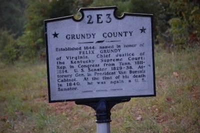
Grundy County
Erected by Tennessee Historical Commission. (Marker Number 2E3.)
Topics and series. This historical marker is listed in these topic lists: Government & Politics • Political Subdivisions. In addition, it is included in the Former U.S. Presidents: #08 Martin Van Buren, and the Tennessee Historical Commission series lists. A significant historical year for this entry is 1844.
Location. 35° 19.406′ N, 85° 54.237′ W. Marker is near Pelham, Tennessee, in Grundy County. Marker is on Hillsboro Highway (U.S. 41), on the right when traveling south. Located at the Grundy County/Coffee County line on Highway 41. Touch for map. Marker is in this post office area: Pelham TN 37366, United States of America. Touch for directions.
Other nearby markers. At least 8 other markers are within 8 miles of this marker, measured as the crow flies. Coffee County / Grundy County (here, next to this marker); Struggling Through the Mountains (approx. 6 miles away); The Dawn Redwood of Monteagle (approx. 6.6 miles away); The Amphitheater (approx. 6.6 miles away); Grundy County / Marion County (approx. 6.7 miles away); Tullahoma Campaign (approx. 6.7 miles away); Monteagle Sunday School Assembly (approx. 6.8 miles away); Trail of Tears (approx. 7.2 miles away). Touch for a list and map of all markers in Pelham.
Credits. This page was last revised on January 24, 2024. It was originally submitted on January 18, 2010, by Sharon N. Goodman of Round Rock, Texas. This page has been viewed 1,005 times since then and 16 times this year. Photos: 1. submitted on January 18, 2010, by Sharon N. Goodman of Round Rock, Texas. 2. submitted on January 24, 2024, by Allen C. Browne of Silver Spring, Maryland. • Craig Swain was the editor who published this page.

